How Prince George’s County was divided and named in colonial times and after independence

Map of colonial Maryland from 1666 by Gowan’s Bibliotheca Americana.
Parishes, hundreds, boundaries marked by rivers and plantations — historically, Maryland was divided up quite differently from how it is today. In May, I wrote a pair of articles on the contemporary difficulties in naming regions of Prince George’s County. This time, I’m going to go all the way back to colonial Maryland to explore how different regions were structured and named.
“Hundreds” in colonial Maryland
Maryland’s colonial period lasted from 1632 until 1776, when it joined the other 13 colonies in rebelling against Great Britain. Like the rest of Maryland’s counties, colonial Prince George’s was divided into subdivisions called “hundreds” and “parishes.”
Parishes were self-governing units that supervised and supported churches — originally Catholic, but later the Church of England. Hundreds were administrative divisions used by the county and colony for collecting taxes and appointing constables and other government officials, but were not self-governing.
The term “hundred” was imported from England, and similarly-named subdivisions were historically used in a number of European countries. While its etymology is unclear, it likely originally referred to an amount of land that could support a hundred families, or provide a hundred men at arms in wartime.
In colonial Maryland, there was a rough association between hundreds and population. New hundreds were established in settled areas as their populations increased, but being of a practical size for administration seems to have also been relevent.
Censuses in colonial Maryland were counts of “taxables” — namely all non-Native men, enslaved or free, over the age of 16 as well as enslaved women over the age of 16 — rather than total populations or numbers of households. However, from a low of about 100 taxables per hundred when the county was established, the number of taxables per hundred rose to about 300 by the 1730s, and remained at roughly that level until the Revolution.
The hundreds of colonial Prince George’s County
When Prince George’s County was established in 1696, it included all of what are now Prince George’s, Montgomery, Frederick, Washington, Allegany, and Garrett Counties, as well as what is now western Carroll County and the northwestern corner of Charles County north of Mattawoman Creek.
Much of this land was frontier with minimal or no European settlement, however. Originally only six hundreds were established, all largely within the boundaries of the present-day county and the District of Columbia.
1. From Swanson’s Creek to Mattaponi Branch be called Mattaponi Hundred;
3. between the Main Branch of the Western Branch and Collington Branch be called Collington Hundred;
5. from Mattawoman to Oxon Branch called Piscattaway Hundred;
6. from Oxon Branch to the falls of the Potomac [Little Falls] called New Scotland Hundred.
The first four of these hundreds were on the eastern side of the county and bounded by rivers in the Patuxent watershed. The latter two were on the western side and bounded by rivers in the Potomac watershed.
The ridge line dividing the two watersheds was left as an implied boundary, as water was initially the main method of transportation in the county, and the northern boundaries of Collington, Patuxent, and New Scotland Hundreds were left somewhat ambiguous, probably because they extended beyond the boundary of significant European settlement.
The hundreds that Prince George's County was divided into when it was established in 1696. Although the county extended to the northwestern border of Maryland, hundreds were only established in the southern part of the county, which had already been settled by Europeans. Image by the author.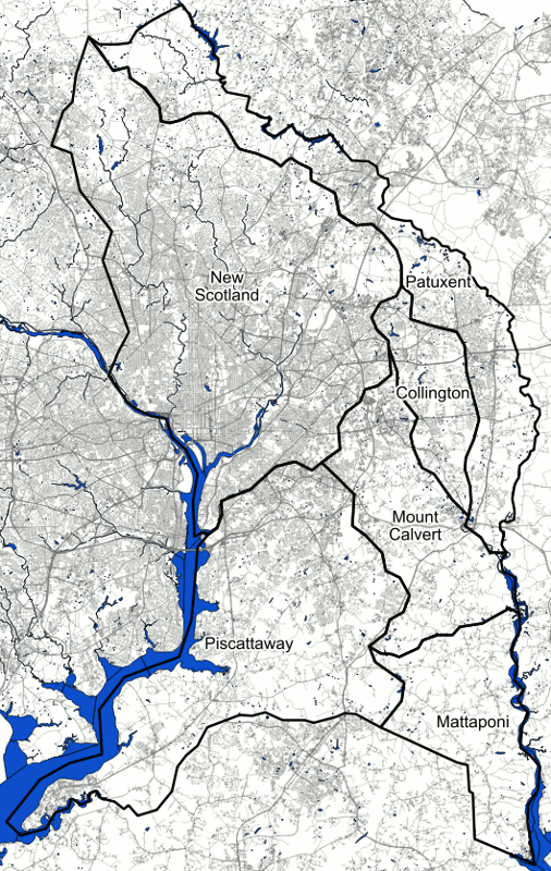
Over the next half-century, new hundreds were established in the northern and western portions of the county. Existing hundreds were subdivided as their populations increased, until 23 hundreds — about half at least partly within the county’s current boundaries — was reached in 1745.
In 1748, however, the number of hundreds was reduced to 12 as the county lost the majority of its land and about a third of its population to two separate acts of the state legislature.
The hundreds that Prince George's county was divided into from 1745 until it was reduced in size in 1748. Not show are Tolonoway, Conocheague, Antietam, Monocacy, Pipe Creek, Seneca, and Linganore Hundreds, in what are now Garrett, Allegany, Washington, Frederick, Carroll, and Montgomery Counties. Also not shown, the town of Marlborough, now Upper Marlboro, was treated as its own hundred. Image by the author.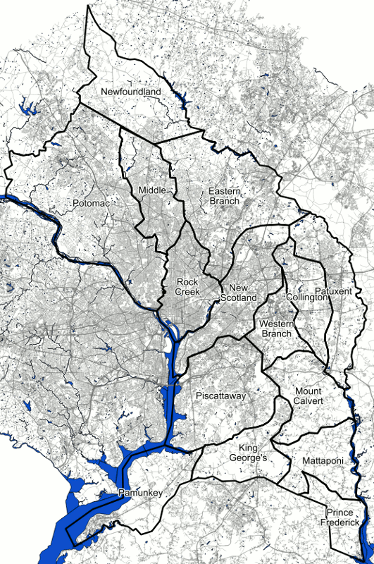
In 1748, Frederick County — then containing all of Western Maryland, the western half of modern Carroll County, modern Montgomery County, and part of the present-day DC — was established, removing Prince George’s County’s less-populous northern and western regions. The southwestern corner of Prince George’s County was returned to Charles County, creating the current border between the two counties.
The American Revolution and the switch to “election districts”
After Prince George’s grew to 23 hundreds, the county was split up in 1748, with the majority of its land and about half its hundreds becoming part of Frederick County (some of which later became Montgomery County). The number of hundreds fell and rose again, but never reached its old maximum.
Then, from 1748 until the American Revolution, several new hundreds were established. The total number reached 20 by 1777, where it remained until 1796, when Columbia Hundred was established on the site where the new capital city of Washington was being built.
This territory was still under Maryland’s control as the administration of the District of Columbia was not transferred from Maryland and Virginia to the federal government until the seat of government was moved to Washington in 1800.
In 1777, the newly established state legislature divided some of the existing hundreds, creating this map. Not shown, the towns of Upper Marlborough (now Upper Marlboro), Bladensburgh (now Bladensburg), and Nottingham (now an archaelogical site near the Merkle Wildlife Sanctuary) were also treated as hundreds. Image by the author.
In 1800, in addition to the cessation of the District of Columbia, the hundreds that had existed for over a century were abolished and replaced with “election districts.” These seem to have been administrative divisions more akin to modern-day precincts, as elected offices were selected at-large for the county as a whole.
Prince George’s County had been divided into 20 hundreds, and these were replaced by five districts whose boundaries were no longer primarily formed by streams and rivers.
In 1800, Prince George's County reached its current size with the seccion of land to form the District of Columbia, and its hundreds were abolished and replaced with these five electoral districts. Image by the author.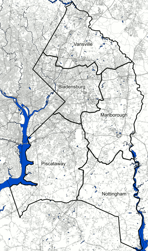
In this new system, the northern portion of the county — largely north of what is now MD-193 — became the Vansville District. Largo, and most of what is now the county inside the Beltway, became the Bladensburg district. Most of what is now greater Bowie and Upper Marlboro became the Marlborough District. The southwestern portion of the county became the Piscattaway District, and the southeastern part became the Nottingham District.
This new system replaced the hodgepodge of hundred names, many of which were based on bodies of water (Eastern Branch Hundred) or plantations (Mount Calvert Hundred) with names that were often taken from the largest community in each district.
Upper Marlboro, Bladensburg, Nottingham, and Piscattaway were colonial-era tobacco inspection ports. The first three had been large enough to be recognized as their own hundreds independent of the agricultural land surrounding them since at least 1777.
19th Century election districts in Prince George’s
In the early 19th Century, election districts gained more importance for administration and were used as the basis for appointing a number of county officers. (Although most officials were still elected at-large from the county as a whole.)
By the time the first detailed map of the county, the 1861 Martinet Map, was published, several of the southern and eastern districts were subdivided and the total number of districts in the county increased to nine. A map of 1860 Census data tabulated by district gives us some demographic data about the county at this time.
The election districts shown on the 1861 Martinet map of Prince George's County; these were the districts used for tabulation in the 1860 Census. Image by the author.
At the beginning of the Civil War, the demographics of the county as a whole matched the rest of southern Maryland below the fall line fairly well: over half the population was enslaved, and the vast majority of free residents had been born in Maryland. However, a major demographic gradient clearly existed within the county.
| District | Total Population | Non-Slaveholding White Residents | Slaveholding White Residents | Free Black Residents | Enslaved Black Residents |
| Vansville | 3,359 | 65 % | 3 % | 7 % | 25 % |
| Bladensburg | 2,908 | 48 % | 4 % | 2 % | 46 % |
| Marlborough | 3,794 | 23 % | 3 % | 2 % | 72 % |
| Nottingham | 2,458 | 36 % | 4 % | 5 % | 55 % |
| Piscataway | 3,040 | 36 % | 5 % | 6 % | 53 % |
| Spaldings | 1,463 | 53 % | 5 % | 8 % | 34 % |
| Queen Anne | 2,130 | 32 % | 4 % | 8 % | 56 % |
| Aquasco | 2,000 | 26 % | 5 % | 9 % | 60 % |
| Surratts | 1,120 | 40 % | 4 % | 2 % | 54 % |
| Total | 22,272 | 40 % | 4 % | 5 % | 51 % |
Of the county’s nine districts, only three — Vansville, Bladensburg, and Spaldings — had a majority of their population not enslaved and majority-white.
The Vansville District’s demographic makeup was probably due to the fact that it was at the north edge of the county and was the only district that had been above the heads of navigation (the furthest up-river a sizable ship can travel) on the Patuxent and Anacostia, even before the rivers silted up.
Accessibility to ships was very important at a time when most transportation — particularly of freight — was by water. Land close to navigable waterways was a lot more valuable and settled first. Being above the head of navigation would have made it less desirable land when the county was first settled as tobacco plantations, making settlement by smallholding farmers more common.
The Vansville District also contained Laurel, which had become a significant mill town by the 1830s and was the only industrial center in an otherwise very agricultural county.
In the case of the Spaldings and Bladensburg districts, I suspect that proximity to the District of Columbia was more relevant to their demographics. Although the capital has not yet established suburban outposts in Maryland in 1860 and most of the District beyond Georgetown and the original L’Enfant city of Washington was still rural, it seems plausible that land near the capital might have been appealing to some migrants from free states.
This is partly confirmed by the fact that the Vansville and Bladensburg districts had just under 20% of their populations born outside Maryland, while 13% of the Spaldings District was born outside of the state. In all of the other districts, this percentage was less than 10%; in several it was as small as 3%.
After the Civil War, the population of railroad towns such as Laurel, Brandywine, and Huntington (now Old Bowie) increased, as did the population of some areas near the DC border, and the number of districts in the County was increased to fourteen as of the time of the 1878 Hopkins Atlas of the county and other areas surrounding Washington.
The election districts shown in the 1878 Hopkins Atlas of Prince George's County. Image by the author.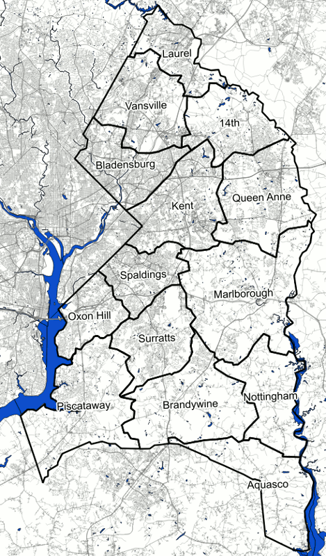
The names of these new districts continued to be based on the names of major settlements and towns within them. Some of these place names, such as Oxon Hill, Surratts, and Bowie (which eventually became the name of what the Hopkins Atlas shows as the nameless “Fourteenth District”) are familiar today.
Others, such as “Queen Anne,” named after a colonial-era tobacco inspection town at the former head of navigation on the Patuxent River, which is a ghost town today, are less so.
Modern Minor Civil Divisions of Prince George’s County
In the aftermath of the 1962 Supreme Court decision in Baker v. Carr that state legislative districts were required to be regularly reapportioned to have equal population, Maryland’s election districts with their relatively stable boundaries became untenable and, in 1972, the state switched to its current system of legislative districts which often cross county lines, and which are redrawn after each Census.
However, the old “election districts” still remain, and their boundaries are updated from time to time by county governments. The main purpose for these boundaries is in the definition of actual legislative districts. Election precincts are also established within individual election districts.
However, the districts have not been significantly reapportioned since they stopped being used for elections, and as a result, the areas that were densely populated in the mid-20th Century have much smaller districts than the rest of the county.
The present-day "election districts" of Prince George's County. They do not correspond to districts for any legislative body, but are used in the definitions of precincts, and are regarded by the Census as Minor Civil Divisions. Image by the author.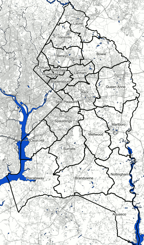
In addition to their use in defining districts used for General Assembly and local elections, Maryland’s election districts are used by the Census as “minor civil divisions” for tabulating data. While every state is divided into counties or county-equivalents (Louisiana’s parishes, Alaska’s boroughs, and independent cities in Virginia, Maryland, Missouri, and Nevada), administrative divisions below the county level vary.
Although the Census does tabulate data by municipalities and Census-designated places, these can only be found in relatively-densely settled areas, and don’t cover the entirety of counties in the same way that counties cover the entirety of states. However, counties in many northeastern and Midwestern states are divided into administrative districts that cover the entire state called “civil townships.”
In states with civil townships, they are used to tabulate Census data as minor civil divisions. Although election districts in Maryland have only vestigal functions today, civil townships are still used for this purpose, unlike the roughly 20 southern and western states where the Census draws its own Census county divisions due to the absense of usable state-drawn divisions.
Is there anything else you’re curious to learn about regarding Prince George’s history?
Note on sources:
The information available online about the history of Maryland hundreds and election districts is fairly limited, and I used several hardcopy texts as resources for writing this post.
Prince George’s Heritage: Sidelights on the Early History of Prince George’s County, Maryland from 1696 to 1800, by Louise Joyner Hieton and published by the Maryland Historical Society in 1972 has a chapter that discusses at length the boundaries and history of the county’s hundreds, and provides a number of maps.
Out of the Past: Prince Georgeans and Their Land, by R. Lee Van Horn, published by the Prince George’s County Historical Society in 1976, was also useful, although it largely consists of quotations and summaries of primary sources, largely historical court and legislative records and newspapers.
Atlas of Prince George’s County, Maryland, 1861, published by the Prince George’s County Historical Society in 1996 and adapted from Martenet’s Map of Prince George’s County, Maryland shows election district boundaries in 1861 and contains 1860 Census data and information of the history of the county’s election districts up to 1861.
The Prince George’s County Historical Society’s 1975 republication of Atlas of Fifteen Miles around Washington Including the County of Prince George, Maryland, by C. M. Hopkins and originally published in 1878, shows election district boundaries in 1878 and contains a useful historical sketch of the county.
Both of the above maps are superimposed over current maps of the county on the M-NCPPC “PG Atlas” website.