We asked, you answered: here are our readers’ names for regions of Prince George’s County
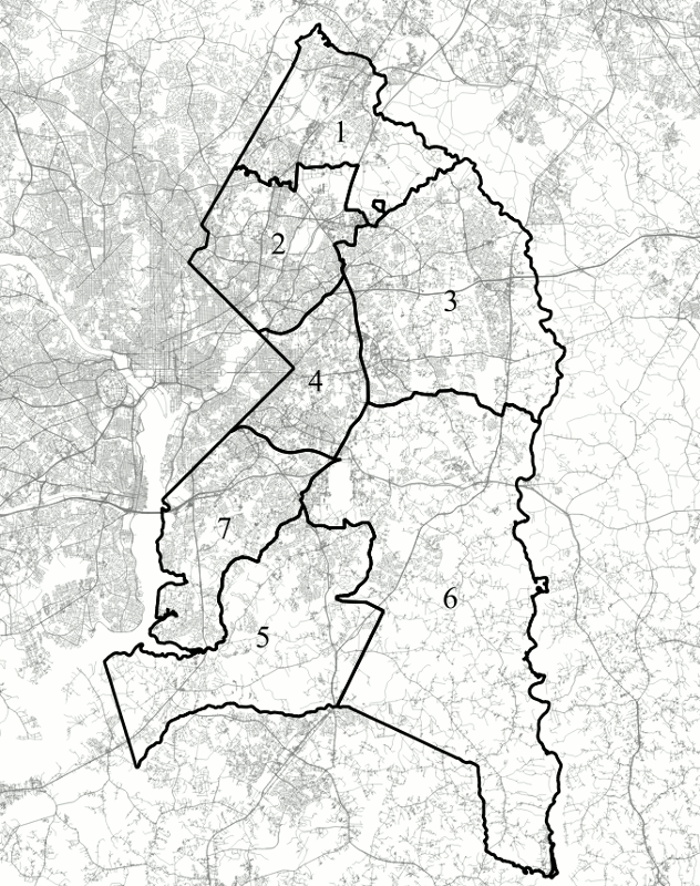
A map of the M-NCPPC's seven "planning subregions" of Prince George's County. Image by the author.
On May 8, we asked our readers what you call different regions of Prince George's county. Now, roughly a hundred responses later, it's time to take stock of your answers.
Where are North County and South County?
One of the primary questions I hoped to answer with this survey was what people mean by “North County,” “South County,” and, if they use them, other directional names like “Central County.” With the name North County, at least, it seemed that people had fairly consistent answers: 22% of respondents called Subregion 1 North County, and 20% of respondents called Subregion 2 North County.
College Park is in Subregion 2, which 20% of respondants call "North County." Image by thisisbossi licensed under Creative Commons._800_534_90.jpg)
Responses in the comments about boundaries for North County were generally based on US-50, which would include Subregions 1 and 2, as well as the northern part of Subregion 3 that is less heavily African-American and where people more commonly speak languages other than English at home. In other words, it seems like “North County” refers, for most people, to that part of the county that is not firmly majority African-American.
If everything north of US-50 is North County, is everything south of the road South County? It turns out not to be quite so simple. Respondents generally seemed to agree that Subregions 5, 6, and 7 are South County, but very few if any respondents referred to Subregions 3 and 4 with this term.
For Subregion 4, Central County was popular: 13% of respondents suggested this term, making it the second-most-popular response after “Capitol Heights.” Subregion 3 was called “Bowie” by 57% of respondents, but the only significantly-used directional term was “East County,” suggested by 6% of respondents.
Carmondy Hills is in Subregion 4, or what readers refer to as "Central County." Image created with Google Maps. 
Suggestions from the comments, if anything, make the matter more complicated. Several people suggested that Pennsylvania Avenue was the boundary between Central and South County which would make all of Subregion 3, but not all of Subregion 4, Central County. One even specifically suggested that Central County referred specifically to the rich suburbs outside the Beltway in Subregion 3.
Based on the demographic analysis I did in my last post, I am inclined to consider Subregion 4 and the part of Subregion 7 inside the Beltway Central County, while calling everything south of US-50 outside the Beltway South County. I think the economic and density divide between areas inside and outside the Beltway, especially south of US-50, is a clear break between regions.
However, given differences in density, considering everything outside the Beltway between the Patuxent Wildlife Refuge and Pennsylvania Avenue East County as a fourth region seems reasonable to me as well. If we go that path though, lumping the Fort Washington area with the rest of South County and the Laurel area with the rest of North County doesn't seem quite right either.
What do people call their own areas?
Unsurprisingly, a large number of replies to the survey — about a third — came from people who live outside of Prince George's County. Of those who replied from within the county, about half were residents of Subregion 2. This is not entirely surprising, since that is where most of Greater Greater Washington's Prince George's County contributors live. However, it also leads to a possible source of bias in the data. To correct for this, it's worth looking at what residents of each subregion call their own areas.
Of the five replies received from Subregion 1, three respondents called their subregion “Laurel,” while one each called it “Beltsville-Laurel” and North County. The replies from Subregion 3 were similarly consistent: of the fifteen we received, roughly half called it “Bowie,” while most of the rest hyphenated Bowie with another place name, including Largo, Mitchellville, and Upper Marlboro.
Laurel is in what respondants call "North County," or Subregion 1. Some people call the entire area "Laurel." Image by Adavidb licensed under Creative Commons.
In general, we received fewer replies from the southern part of the county: four from Subregion 4 and from Subregion 6, three from Subregion 7, and only one from Subregion 5. Still, there was a certain amount of agreement. The respondent from Subregion 5 referred to their subregion as South County, while half of the respondents from Subregion 6 called theirs Upper Marlboro and half of the respondents from Subregion 4 called theirs “Inner Beltway”.
All of the replies from Subregion 7 consisted of the names of Census-designated places in the subregion, and all of them included Fort Washington: we got one response of “Fort Washington,” one of “Oxon Hill-Fort Washington,” and one of “Temple Hills, Fort Washington, and Oxon Hill.”
What did our readers call each subregion?
Some subregions — particularly those dominated by a single large municipality or ZIP code name, or both, had very consistent responses for what they should be called. For example, 48% of respondents called Subregion 1 Laurel, while 22% preferred North County, and 19% preferred “Laurel-Beltsville.”
| Laurel | 48% |
| North County | 22% |
| Laurel-Beltsville | 19% |
| Other | 11% |
Likewise, a full 57% of respondents called Subregion 3 Bowie. The second-most-common reply was “Bowie-Largo” at 9%, followed by respondents who said they had no general name for the region and those who called it East County, both at 6%. A full 22% of responses for this subregion, though, were responses that were given by five or less people, which I've lumped together under “Other.”
| Bowie | 57% |
| Other | 22% |
| Bowie-Largo | 9% |
| No General Name | 6% |
| East County | 6% |
Names for Subregion 6 were similarly consistent, with 52% of respondents referring to the subregion as “Upper Marlboro,” which is the name the Post Office uses for most of this region. The next most common results were South County, at 19%, and “Southeast County,” at 5%, while 24% of respondents had some other name for the area.
| Upper Marlboro | 52% |
| Other | 24% |
| South County | 19% |
| Southeast County | 5% |
While Subregions 5 and 7 did not have majority or near-majority responses, they still had clear pluralities for one response. Thirty-seven percent of respondents called Subregion 5 South County, while the next most common reply was Clinton, at 18%, followed by “North Waldorf,” at 9%, and Brandywine, at 8%. Over a quarter of respondents came up with other names for the subregion.
| South County | 37% |
| Other | 28% |
| Clinton | 18% |
| North Waldorf | 9% |
| Brandywine | 8% |
Likewise, 30% of respondents called Subregion 7 Oxon Hill, while 15% called it South County, 11% called it National Harbor, 10% called it Oxon Hill-Fort Washington, and 8% called it Fort Washington. As an interesting note, about half of respondents misspelled Oxon Hill as “Oxen Hill.”
The confusion is likely due to the fact that “oxen” is the correct spelling for the plural of “ox,” and “Oxen Hill” seems like a reasonable name for a place to have. The actual origin of Oxon Hill's name, however, is an Eighteenth-Century manor house that was named after “Oxon.”, the Latin abbreviation for “of Oxford” that is used as a postnomial by graduates of Oxford University.
| Oxon Hill | 30% |
| Other | 26% |
| South County | 15% |
| National Harbor | 11% |
| Oxon Hill-Fort Washington | 10% |
| Fort Washington | 8% |
The subregions inside the Beltway seem to produce a bit less of a consensus about their names. This may be due to the fact that they're denser and generally have smaller municipalities and Census-designated places, but it may also be influenced by the fact that our respondents — who were largely from Subregion 2 — are more familiar with these areas, and so have more distinct places within them in mind.
The most-frequently suggested name for Subregion 2 was North County, but only 20% of respondents suggested it. Forty-five percent of respondents suggested some combination of the three largest cities in the subregion: College Park, Greenbelt, and Hyattsville. These responses were divided among four different answers — College Park-Greenbelt, College Park, Hyattsville, and College Park-Hyattsville — which each got between 13% and 9% of responses.
| North County | 20% |
| Other | 20% |
| College Park-Greenbelt | 13% |
| College Park | 12% |
| Hyattsville | 11% |
| College Park-Hyattsville | 9% |
| No General Name | 7% |
| Route One Corridor | 7% |
The only other common suggestion for Subregion 2 was “Route One Corridor,” which got 7% of responses. Since College Park and Hyattsville are along the Route One corridor, and Greenbelt is quite near it, the suggested names other than North County all seemed to focus on the central area of the subregion and ignore the very heavily Hispanic corridor along the Montgomery County border and the very heavily African-American areas along the Annapolis Road corridor.
For Subregion 4, there was even less agreement. Fifteen percent of respondents suggested Capitol Heights and 13% of respondents suggested Central County, and the only other responses to get more than five votes were Inside-the-Beltway, at 9%, and Landover-Suitland, at 7%. A full 47% of replies were unique or nearly-unique names.
| Other | 47% |
| Capitol Heights | 15% |
| Central County | 13% |
| Inside-the-Beltway | 9% |
| No General Name | 8% |
| Landover-Suitland | 7% |
Overall, these results suggest that our readers have a pretty clear understanding of what to call regions outside the Beltway: Laurel to the north, Bowie to the east, Upper Marlboro to the southeast, and Fort Washington or Oxon Hill to the south. Inside the Beltway though, while it's clear that people don't think of the areas north and south of US-50 as the same — unsurprisingly given their very different demographics — it also seems that they don't have particularly consistent names for them.