What do you call different regions of Prince George’s County? Even for locals, it’s complicated.
A map of M-NCPPC's Planning Subregions of Prince George's County. Image by the author.
Prince George's County has different regions with very different needs. While less populous than Montgomery and Fairfax, with 900,000 residents Prince George's is the fifty-eighth most populous county in the country and has a larger population than five states: Alaska, Vermont, Wyoming, and the Dakotas.
Still, despite the county's large size, there is a tendency for outsiders to see it as a monoculture. Even locally we lack the terminology to discuss its varied regions, so I've created a short survey to learn how you refer to them.
It can be hard to figure out how to talk about Prince George's regions
Nationally, Prince George's County is famous for being the most affluent majority African-American county in the country. Locally, it's often seen by outsiders as a morass of poverty and bad schools. Neither one of these descriptions fits the county as a whole.
Prince George's County has both very poor and very rich areas. It has areas where a vast majority of the population is African-American, and areas where they aren't even a plurality of the population. There are regions of the county where nearly everyone speaks English as a first language, and regions where the majority of households use a language other than English at home. There are regions of nearly-exurban sprawl, and regions that are among the Washington region's oldest and densest suburbs.
When people do acknowledge the differences within the county and try to talk about them, they often run into a problem with vocabulary.
First, there aren't generally-agreed-on terms for parts of the county, beyond the names of municipalities and Census-Designated Places (CDPs). There are more than 50 municipalities and CDPs in the County, and they are often quite small. Case in point: in less than six miles inside the Beltway, US-1 passes through six different municipalities: Mount Rainier, Brentwood, North Brentwood, Hyattsville, Riverdale Park, University Park, and College Park.
Sometimes people use the names associated with ZIP codes to describe parts of the county, but many of those are quite small as well and they have the added problems of being awkwardly shaped or conflicting with the names of the municipalities they contain. For example, the Post Office considers both the Takoma-Langley Transit Center and some neighborhoods along Central Avenue to be in Hyattsville, but gives Brentwood, Mount Rainier, Bladensburg, Riverdale Park, and College Park their own addresses, even though they are squarely in between these locations.
Common distinctions residents use are ambiguous, and encompass very different areas
One of the most obvious ways to divide Prince George's County into regions is to distinguish between the parts of the county inside and outside of the Beltway. This has a certain sense to it: it's easy to see on a map, and — as in the rest of the region — neighborhoods inside the Beltway tend to be older and denser than those outside it. However, this would sweep together very, very different areas: Langley Park, College Park, and Suitland have fairly little in common, and Laurel at the northern tip of the county and Aquasco at its southeastern tip have even less.
The other commonly-used division of the county is between “North County” and “South County.” This clarifies the distinction between areas that are almost entirely African-American and the ones that are not, at the expense of lumping together as equivalent streetcar suburbs and rural areas, and extremely poor and extremely rich neighborhoods.
This terminology has an additional problem: no one seems to agree on where the boundary between North County and South County is. In the last week I've heard residents argue that the boundary should be US-50, that it should be Central Avenue (the definition I grew up with living in New Carrollton), and that it should be Pennsylvania Avenue. Some people include a “Central County” as well, but that leaves open the question of what the boundaries of Central County are as well.
Can we use government terminology to describe areas of the county?
While Montgomery County's regional service centers serve districts with names — Upcounty, Mid-County, Eastern Montgomery, Bethesda, and Silver Spring — Prince George's County doesn't do anything similar. We could potentially refer to areas by county council districts, but the county has nine of these and most residents — this author included — couldn't draw any other than perhaps the one they live in on a map.
The M-NCPPC, however, does use named “planning areas” for the county (except for the City of Laurel, which has its own planning department) for planning purposes. However, there are roughly 35 of them, which poses the same problem as simply referring to municipalities and CDPs.
A map of M-NCPPC's Planning Areas of Prince George's County. Image by the author.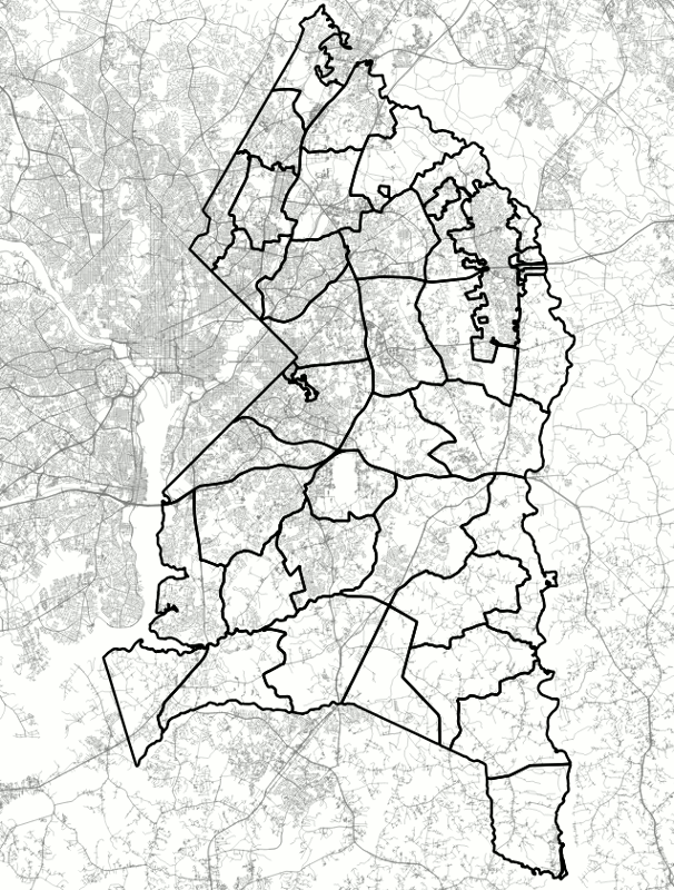
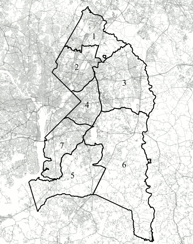
These planning areas are grouped into seven “planning subregions,” which work rather better for referring to different parts of the county. However, unlike the planning areas, the planning subregions don't have names: they are simply numbered from Subregion 1 (the area north of the Beltway and the Patuxent National Wildlife Refuge) to Subregion 7 (the area inside the Beltway south of Suitland Parkway, and the area directly south of the Beltway and north of Piscataway Creek).
A map of M-NCPPC's Planning Subregions of Prince George's County. Image by the author.
To find out how our readers refer to these different parts of the county, I've created a short survey. Please fill it out if you feel familiar with Prince George's County, even if you don't live or work here! Next week, I will follow up with a post discussing the results.