Where you live is obviously important. But around here, it’s not that easy to define.
_800_565_90.jpg)
A map of incorporated municipalities (orange) and census-designated places (yellow) in the Washington, DC area. County and independent city boundaries are bold, and federal government property is green. I made each of the maps in this post using QGIS with data from the US Census. Click for a full size version. Image by the author.
When we think of a “town” or “city” we might imagine a place with fixed boundaries and its own government, with a mayor and council. That's how communities are organized in most of the United States. But in much of Maryland and Virginia, “city government” doesn't really exist.
Every state in the US is divided up into counties (sometimes called by other names) that cover all land in the state. Counties cover a variety of types of land, from very-low-population rural land to dense cities.
Cities and towns, like counties, are forms of local government created by states. States often give communities within a county their own borders and governments, “incorporating” them and leaving the county government to pass ordinances and provide services for the “unincorporated” land outside the city government.
We have few incorporated places around here, which can be an issue
Newcomers to the Washington region are often surprised by fact that most of the District’s Maryland and Virginia neighbors are unincorporated places, with local governance handled solely by the county.
While essentially all land in New England is incorporated as a city or town, and populated places in the Northeast and Midwest tend to always be incorporated, Maryland and Virginia—like other states in the Southeast—have strong county governments and communities rarely bother to incorporate.
Prince George's and Montgomery Counties are actually unusually municipality-rich for counties in Maryland. In fact, Howard County and Baltimore County have no municipalities within their boundaries.
In Virginia, incorporated cities, such as Alexandria, Falls Church, and Fairfax, are independent of any county. Incorporated towns are part of counties, but they are rare: there are none in Arlington County, and only Clifton, Herndon, and Vienna in Fairfax County are incorporated.
The rarity of incorporated places in the Washington region means that many communities do not have direct authority over their governance, but instead have regulations and services that the county government administers. It also makes it much harder to talk about the places we live, work, and shop.
The vast majority of the land near DC is unincorporated, including such major communities like Bethesda, Silver Spring, Reston, and Oxon Hill. This means that residents have to rely on unofficial place names to describe where they live and work.
The question is, what unofficial place names to use? A common solution is to use the names that the Post Office associates with ZIP Codes. Unfortunately, these names are less-than-practical for many purposes.
For one thing, the Post Office often uses the same name for very large areas: much of Montgomery County is given only four place names—Silver Spring, Chevy Chase, Bethesda, and Rockville—by the Post Office.
This can be even more confusing when a ZIP Code has the name of a municipality it does not include: much of Prince George's County is considered Hyattsville or Upper Marlboro by the Post Office, including areas nowhere near these incorporated places.
Here’s how the Census tries to solve this problem
The fact that many communities that are not incorporated still form identifiable “places” with names that are generally recognized by the inhabitants is a problem for the Census as well.
In order to tabulate demographic data for such communities, the Census Bureau defines “Census-Designated Places” (CDPs). These places are intended to be “statistical geographic entities representing closely settled, unincorporated communities that are locally recognized and identified by name.”
CDPs were first defined for the 1950 Census and, although the definitions are updated every ten years for the new Census, the they are generally relatively stable. This makes them a useful way to describe place names in the DC area, particularly since statistical or demographic statements about places are generally based on data from the Census Bureau.
Place names can extend far beyond the municipality
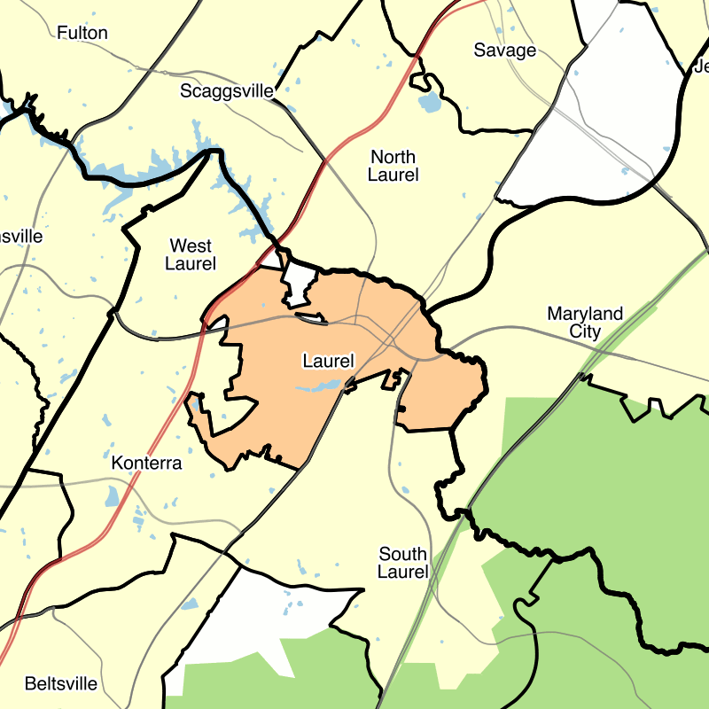
Even when an incorporated municipality with a given name exists, there can be popular confusion about where its borders are. A number of people I've talked to have refused to believe that the City of Laurel is entirely in Prince George's County because a large section of Howard County is known as North Laurel. In fact, there are three different CDPs bordering Laurel that have Laurel in their names.
A map of Laurel, Maryland (orange) and surrounding census-designated places (yellow). Image by the author.
Many actual towns and cities here are very small
In the late 19th Century, suburban residential places began to grow up along the B&O Railroad lines in Montgomery and Prince George's Counties. The opening of streetcar lines into Maryland soon led to these being joined by a number of streetcar suburbs in the early 20th Century.
The new communities tended to be quite small, and were bounded by rural countryside. This tended to result in the formation of very small municipalities, such as the numerous small cities and towns along the US-1 Corridor in Prince George's County.
This is particularly noticeable among the communities that developed as streetcar suburbs along the Rhode Island Avenue streetcar and the Bladensburg Road / “Gretta Line” streetcar in Prince George's County. A number of the towns along US-1 and the District border in Prince George's County have small populations and relatively low median incomes, which both contribute to very small tax bases.
A map of the Rhode Island Avenue corridor on the District-Prince George's border. Municipalities are in orange and census-designated places are in yellow. Image by the author.
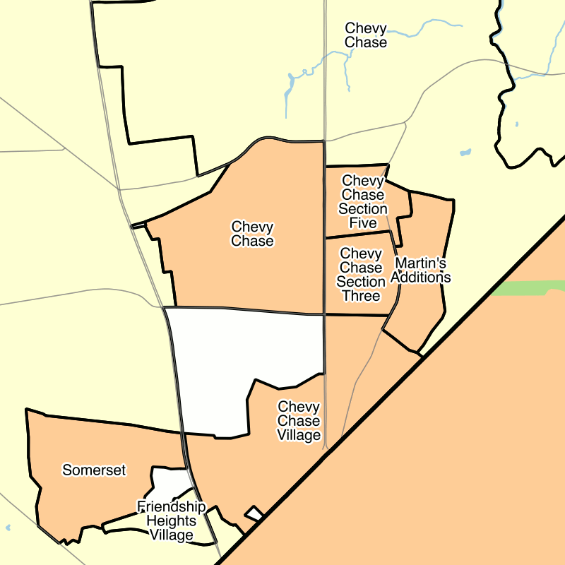
Similarly small populations are seen in the municipalities—many of them with “Chevy Chase” in the name—along Connecticut Avenue in Montgomery County. Most of these municipalities have their roots in streetcar suburbs developed by the Chevy Chase Land Company starting in 1890, though they were not incorporated for several decades.
A map of the Connecticut Avenue corridor on the District-Montgomery border. Municipalities are in orange and census-designated places are in yellow. Image by the author.
While many of the early suburban communities in Prince George's and Montgomery Counties were incorporated, another alternative was forming “special tax districts,” eight of which were formed along Wisconsin and Connecticut Avenues in Montgomery County. These districts, unlike municipalities, do not have the power to pass ordinances or perform many of the functions of a municipality, but can levy property taxes.
These districts were originally created to provide for road maintenance and street lighting before the county government took on those responsibilities in unincorporated areas. It is not clear to me why they were formed instead of municipalities, but it seems to have been a short-term phenomenon. All eight were created between 1914 and 1924.
Three such districts—the Friendship Heights and “The Hills” Special Tax District, the Oakmont Special Tax District, and the Village of Drummond Special Taxing Area—still exist in Montgomery County, while the other five—Chevy Chase Section 3, Chevy Chase Section 5, Martin's Additions, Chevy Chase View, and North Chevy Chase—incorporated between 1982 and 1996.
Interestingly, the five special tax districts in Montgomery County that have incorporated are the only new municipalities to have incorporated in Maryland since 1953. This may be due to a 1954 law that changed the process for municipal incorporation.
Before 1954, municipal charters were granted by act of the state legislature. Since 1954, new municipalities require the permission of the county government to hold a referendum: since a municipality receives tax revenue and authority that would otherwise belong to the county government, counties may be less inclined to allow new municipal incorporations than the state legislature was.
City borders don’t necessarily make sense
While no new municipalities have been incorporated in Maryland in the last sixty years, except by the conversion of special tax districts, a number of municipalities have expanded their borders to annex territory. In some cases, this has led to rather odd borders: for example, New Carrollton has annexed the road right of way of a portion of Annapolis Road and Veteran's Parkway, along with some commercial properties on this stretch of road.
A map of New Carrollton, Maryland (orange) and surrounding census-designated places (yellow), showing the salient of annexed road right-of-way along Annapolis Road and Veterans' Parkway. Image by the author.
Thumbnail: Image by the author.
