Who drives cars, who gets hit by cars, and why

Wide, fast-moving arterial roads are particularly dangerous for pedestrians. Pennsylvania Avenue by Mike Maguire licensed under Creative Commons.
It’s an unfortunate fact about DC that in neighborhoods where car ownership is low, the rate of pedestrian crashes is high. You may have seen this chart making the rounds on Twitter a few weeks ago, showing a strong inverse correlation:
Who drives cars: Who gets hit by cars: pic.twitter.com/dAdjC10XnO
— Charlotte Lee | 미국아줌마 (@cljack) January 21, 2021
You may think (as a lot of people did) that it’s obvious that “more people walking around” leads directly to “more people getting hit by cars.” But even if you set aside the countless cities around the world with lower rates of both car ownership and pedestrian crashes, and look specifically at DC, this doesn’t hold up. The main driver of the disparity between crashes in high and low car ownership neighborhoods isn’t the amount of time people spend walking, but where they’re walking — and where they’re not walking.
As of 2019, a third of households in DC did not have access to a car. That’s a significant portion of the population that rarely or never has a need to make cross-town vehicle trips, but nevertheless a huge and costly road infrastructure exists for that sole purpose. The DC Department of Transportation classifies these roads — wide, high-speed-limit roads that are purpose-built to get a high volume of car commuters quickly through the city — as “arterials”. Arterials are dangerous to cross on foot under the best conditions, but especially so when it’s dark or the weather is bad. So it’s no surprise that they account for the vast majority of pedestrians struck.
DC road types and pedestrian crashes between 2015 and 2020. Data from Roadway Blocks and MPD Crash Reports datasets. Image by the author.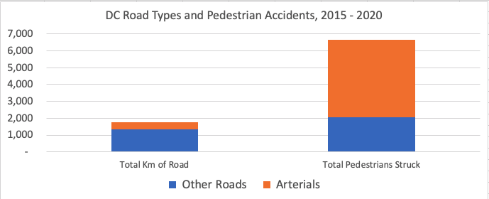
Every residential neighborhood in DC is saddled with at least a few kilometers of these dangerous commuter roads (I am defining residential neighborhoods by excluding those made up of water, parkland, military bases, or with more daily Metro riders than population.)
Minor and principal arterial roads in DC outside the central business district. Data from Open Data DC. Image by the author.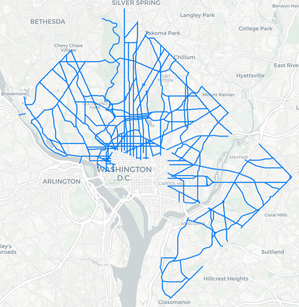
And yet, although the arterial roads are not disproportionately present in residential areas of the city with lower car ownership, pedestrian crashes on them certainly are. This is in stark contrast to pedestrian crashes on other types of roads, which are split about equally between the neighborhoods with higher and lower car ownership rates.
Pedestrians struck on arterial roads versus all other roads. Data from Open Data DC. Image by the author.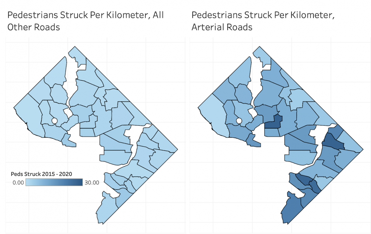
Car ownership rate appears to actually be more important as a determinant of pedestrian crashes than other socioeconomic factors such as per-capita income. Take a look at the number of pedestrian crashes on each kilometer of arterial road for the 35 residential DC neighborhoods on the map above, plotted against the car ownership rate of the neighborhood:
Household car ownership plotted against pedestrians struck per kilometer of arterial road. Image by the author.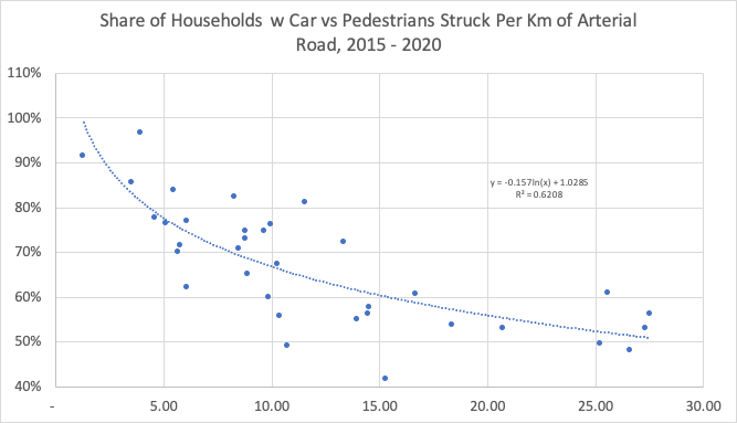
And here’s the same neighborhoods, with the pedestrian crashes plotted against per-capita income instead of car ownership. If you want to get in the weeds on statistics, the r-squared value is much lower (0.26 vs 0.62). In other words, there’s a much weaker correlation.
Federal Adjusted Gross Income (FAGI) per capita plotted against pedestrians struck per kilometer of arterial road. Image by the author.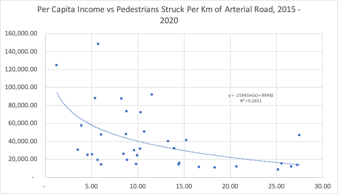
Population density (a popular theory of Twitter reply guys) has even less explanatory power. A neighborhood’s rate of arterial pedestrian crashes has only the vaguest of relationships with its population density (r-squared of 0.09):
Population density plotted against pedestrians struck per kilometer of arterial road. Image by the author.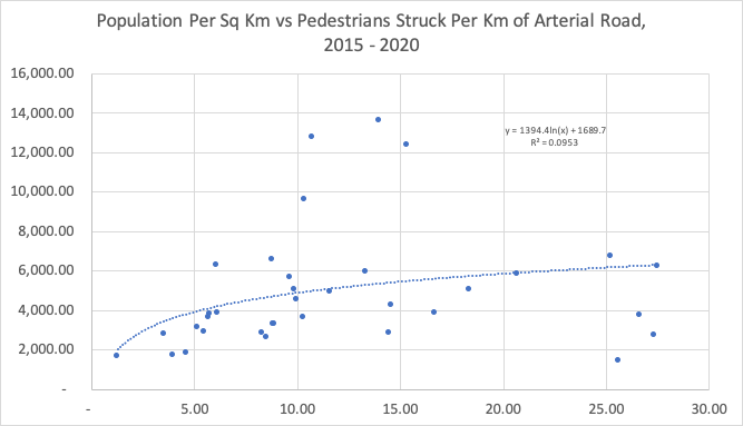
So why does the deadliness of arterial roads vary so much across the city, and why does it correlate so strongly with the car ownership rate instead of with population density or income level? We don’t know, but my own experience could hint at a possible answer. I live in Friendship Heights, where it’s easy to walk to most of your daily errands; I chose to live here in large part because my family wants and needs to walk to things. But running errands on foot often requires crossing Wisconsin or Western Avenues, which are high-traffic, wide arterial roads. After a few too many close calls with aggressive jerks running red lights and ignoring walk signs, I now drive to destinations across these roads if I’m going after dark or during evening rush hour, or I have both of my small children with me. Crossing arterial roads under those conditions is dangerous enough that my preference for walking over driving is outweighed by my concern for my family’s safety.
I live at the red dot. In the past few weeks I’ve chosen to drive my car to destinations at the blue dots, despite them being a quick walk away, because it’s so dangerous to walk across arterial roads after dark, in bad weather, or with small children. Image by the author.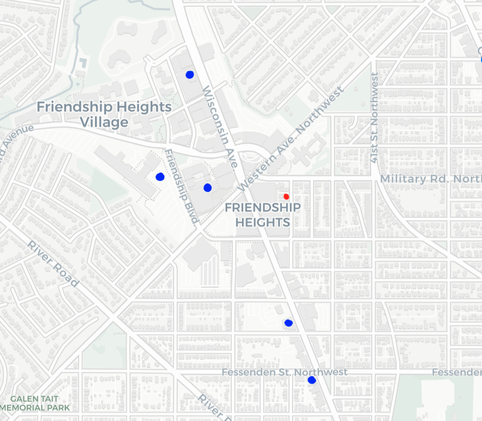
I can make that choice, because I have access to a car. What if I didn’t? Well, I could choose to simply never run any errand that required me to be outside after dark or in bad weather. I could refuse to see any doctor whose office is on the other side of Wisconsin Avenue from me. I could choose to avoid grocery stores and exclusively eat whatever food I can buy at CVS. But in reality, I wouldn’t do any of that. I would cross the dangerous roads to do what I needed to do, and hope that I was lucky. Every day, countless families are making that gamble. Too often, some of them lose it.
For many reasons, the answer isn’t to put everyone in cars. So instead, maybe it’s time to rethink wide, fast-moving arterial roads, the benefits they deliver to the residents of DC, and whether those benefits outweigh the costs.
Thank you to Maria @TheHillIsHome for her help in reviewing and making suggestions. For more detail about the methodology used in this article, please reach out to the author on Twitter at @cljack.