Posts tagged Maps
-

Not every map is the same, actually
Inequity is spatial. DC’s geography reflects inequities that have been built into it over the course of generations, but sometimes those patterns defy our expectations. Keep reading…
-

What could an intercity bus network look like in Maryland?
Many states provide intercity bus networks to connect communities across long distances. What could such a system look like in Maryland? Introducing “MARC Bus,” Porter Crumpton’s proposal for a statewide intercity bus service. Keep reading…
-

Look at this scooter & e-bike heat map of DC
Make sense of where people are riding scooters and e-bikes in the Washington region with this interactive heat map. Keep reading…
-

Who drives cars, who gets hit by cars, and why
In DC, neighborhoods where car ownership is lowest see the highest rates of pedestrian crashes. Why? Keep reading…
-

A look at the region’s intersections
Street networks are an important part of urban form, both for pedestrians and for public transit. Here’s a look at the region’s intersections. Keep reading…
-

These maps show how racial demographics have changed in the region since 1970
Today, the Washington region is known for having very diverse suburbs, including Prince George’s County, the largest suburban majority-African-American county in the country. However, 50 years ago, the region’s suburbs were nearly entirely white, while racial and ethnic minorities were largely concentrated in the District east of 16th Street NW. Keep reading…
-

Check out this map of Washington streetcar and proposed subway lines in 1944
Jake Berman, an artist living in New York City, recently sent us this beautiful map of existing streetcar routes and proposed subway lines in DC and surrounding areas in 1944. Keep reading…
-
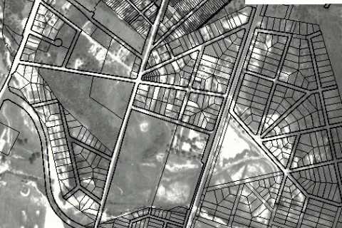
This GIS atlas reveals the history of Prince George’s County
Hey history buffs: Prince George’s Atlas has a slew of fascinating old aerial photos, maps, and other cartographic information about the county, including property boundaries and environmental information. What did your neighborhood look like a century ago? Keep reading…
-

Take a look at this map of DC’s horse-drawn streetcar routes
New York-based artist Jake Berman created and shared this unique map of streetcar routes in DC. But this isn’t a map of the modern, sleek streetcars we have today. Nor is it a map from the 20th century showing electric streetcar routes, such as the map Berman made that detailed streetcars and proposed subways from 1944. Keep reading…
-

In 1979, was your neighborhood “sound” or “distressed”?
DC looked very different in 1979. A map of neighborhood housing conditions shows just how much. In many DC neighborhoods that are now in high demand, the housing stock was in danger decades ago. Keep reading…