Turning Baltimore’s trails into a network could bring Charm City a near-term win
Jones Falls Trail in Baltimore by charmcity123 licensed under Creative Commons.
The Baltimore Greenways Trail Network is a relatively new idea. Other projects working their way through Maryland’s transportation pipeline, including the Purple Line, the cancelled Baltimore Red Line, the Corridor Cities Transitway, and the Southern Maryland Rapid Transit Project, each date back decades. But the Baltimore Greenway, a proposed 35-mile network of urban trails ringing almost the entirety of Baltimore City, only dates back four or five years — Rails-to-Trails Conservancy’s earliest planning meetings for the project launched toward the end of 2015. But despite its newness, the trail network, spearheaded by a coalition with more than 40 stakeholder members, has a key advantage: it’s already almost done.
It would only take 10 more miles of trails — about $28 million — to complete the 35-mile network, which would link up to 75 neighborhoods and could come with millions of dollars in economic and social benefits. A new report by consulting firm Ernst & Young, commissioned by the Greater Washington Partnership (GWP), argues that the Baltimore Greenways Trail Network has the potential to not only bring countless benefits to the city, but also to do so sooner than any major transit project proposed in Central Maryland.
The Greenway would be quick to complete because the concept makes use of already existing trails, including:
- The Gwynns Falls Trail, which originates in Baltimore’s largest park, Leakin Park, and has run about 15 miles along the Gwynns Falls river since 1998;
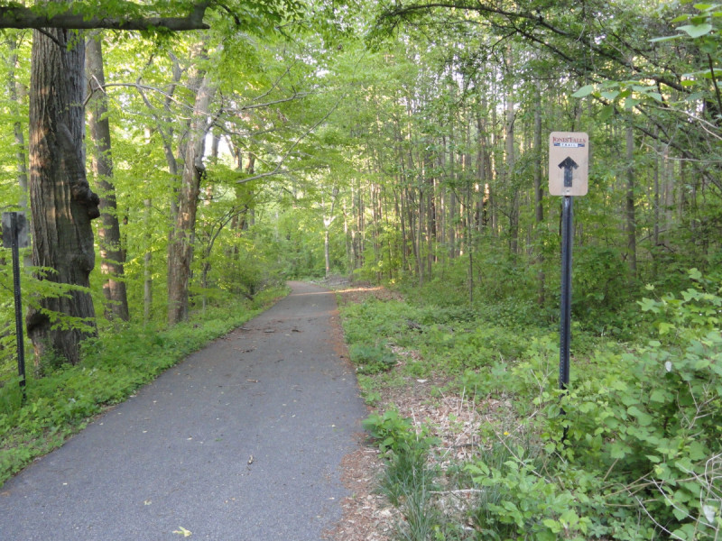
- The Jones Falls Trail, a 9-mile path, under various bits of construction since 1999, which runs north-south alongside Baltimore’s Jones Falls River from the Mt. Washington neighborhood to the Inner Harbor; and
- The Herring Run Trail, a 2.5-mile path that runs through Herring Run Park in Northeast Baltimore and alongside scenic Lake Montebello.
Jim Brown, who leads the Baltimore Greenways coalition as Director of Projects for Rails-to-Trails’ TrailNation Program, said the group began by plotting out how to connect Baltimore’s trio of already extant paths. Brown, various officials from Morgan State University, and park volunteer groups began taking “guerrilla hikes” through the city.
“We just started exploring them on our own on foot to ‘truth out’ this idea of connecting in between [the trails]”, Brown said. “And the more we talked about it with city agencies and planners in the city, everybody was like ‘this is an interesting idea, let’s explore it.’”
A map showing the proposed Baltimore Greenways Trail Network. Image by Rails to Trails Conservancy used with permission.
The Greenway plan proposes five segments of new trails (shown in the map above):
1. The East 33rd Street Corridor would have a 1.4-mile long path connecting the Herring Run Trail and Lake Montebello in the east with part of the Jones Falls Trail in the west. A version of this segment was dreamed up by the legendary Olmsted Brothers landscape architecture firm as part of their original 1904 plan to create a municipal park system for Baltimore. Currently it consists of car lanes and a median strip, but the Baltimore Greenway Trails Coalition is working with city officials to create what it describes on its website as a “multiuse pathway,” paid for in part by a Maryland State Bikeways grant.
This segment would connect two of Baltimore’s biggest and most economically important colleges, historically Black Morgan State and Johns Hopkins University. Also on the route would be the Waverly Farmers Market, one of the largest and most popular farmers markets in the city; the Baltimore Museum of Art; and yet another popular Baltimore park, Wyman Park Dell.
“It’s really an incredible opportunity to connect those parks and all of the neighborhoods along the corridor,” Brown said.
2. The West Gwynns Falls Parkway segment would run two miles from Druid Hill Park, just northwest of the city center, westwards towards Leakin Park. Like the East 33rd Street Corridor, the Gwynns Falls Parkway is another Olmsted Brothers creation, and together these two routes would create what Brown and Rails-to-Trails call a “Northern Loop.” The Gwynns Falls Parkway segment would pass through two major parks, Druid Hill Park and Hanlon Park (which contains Lake Ashburton), as well as historic Black neighborhoods like Rosemont, Mondawmin, Ashburton, Walbrook Junction, and Auchentoroly Terrace. It would pass by Baltimore’s other HBCU, Coppin State University, and one of its main shopping and transit hubs, Mondawmin Mall, as well as the Maryland Zoo and another celebrated mobility path, the Big Jump.
This segment would pass Gwynns Falls Parkway’s intersection with Reisterstown Road, which according to the National Highway Safety Administration is “the most dangerous intersection in Maryland” with 46 crashes in 2015 alone. The report suggests that by adding safer street crossings, more traffic calming measures, and improved bike/pedestrian facilities, the Greenway could improve safety on a traffic-clogged parkway originally intended as an extension of the city’s park system.
3. The Middle Branch segment runs alongside the Middle Branch of the Patapsco River in South Baltimore, and parts of it have already been built. This segment has received more than its fair share of attention of late, partly because of its proximity to the controversial Port Covington mixed-use project and partly because of the work Baltimore City officials, the South Baltimore Gateway Partnership, and the Parks & People Foundation have been pouring into revitalizing the park and trail space along the area’s waterfront.
Brown sees closing the gaps in this portion of trail as a way to create a “Southern Anchor” to the Baltimore Greenway, connecting downtown and the Gwynns Falls and Jones Falls trails with Middle Branch Park.
“A lot of the neighborhoods adjacent to that gap are very supportive and want to be connected,” Brown said. “There’s a lot of African-American history in [the neighborhoods along the Middle Branch] and we view this project as one way for those neighborhoods to start telling those stories to visitors that will come through and highlight the significant history of South Baltimore to the rest of the city.”
4. The “Highlandtown Highline” would run northeast from Canton, a waterfront neighborhood in southeast Baltimore. Originally built as part of the old Pennsylvania Railroad line, this segment of rail hasn’t had any trains on it in more than 40 years. Baltimore City has started discussions about the possibility of acquiring the land and turning it into part of the Greenway.
The Highlandtown route would pass through neighborhoods including Armistead Gardens, Orchard Ridge, Orangeville, Baltimore Highlands, Highlandtown, Brewers Hill and Greektown. Like the High Line in Manhattan, much of the Highlandtown Highline would be elevated.
“This is the classic example where it’s much more than just a trail,” Brown said. “It connects thousands of people and dozens of neighborhoods from East Baltimore and Northeast Baltimore down to the Inner Harbor and down to Downtown. The corridor is wide enough to be more than a trail, there could be an improved playground and new tree plantings and parks and all sorts of things to connect to the neighborhoods along the corridor.”
5. The BGE Utility Corridor, is, as the name might suggest, a utility corridor owned by Baltimore Gas & Electric. The utility has expressed its support to Baltimore City officials and Baltimore Greenway Trails Coalition members for turning the corridor into a 1.5-mile trail, and the city and BGE are currently in negotiations to map out the terms. The BGE Utility Corridor would connect the Highlandtown Highline with the Herring Run Trail in the northeast.
“[BGE’s support is] great news because it shows the corporate community in Baltimore supporting this project and realizing the value of making those connections,” Brown said, adding that the section “would be much more wild, it would be about a mile and a half of meadow trail.”
A rendering of the Baltimore Greenway Trails Network proposal viewed from southeast Baltimore. Image by Unknown Studios and Rails to Trails Conservancy used with permission.
The benefits of a trail network
Ernst & Young’s report lays out several benefits of completing the Greenway for Baltimore City, many of them health-related — it’s no coincidence that much of the groundwork for the trail network came from Rails-to-Trails and local bicycle and mobility advocacy group Bikemore securing a “Plan4Health” grant from the American Planning Association to “promote the inclusion of health in non-traditional sectors.”
But Joe McAndrew, the Vice President of Transportation for the Greater Washington Partnership, argues that the Baltimore Greenway would also be a boon to Baltimore because of its economic potential, not to mention the likelihood of actually being able to complete it within the next four years.
“Trails are a key component of transportation, just like a transit line or a roadway,” McAndrew said. “We need to be providing healthy, safe opportunities to be able to get to key destinations and I think if you look at an opportunity to deliver meaningful, transformational kinds of near-term wins, from Baltimore to Richmond, the Greenway is right up there in the pack.”
The existing Jones Falls Trail in Druid Hill Park. Image by Steve Earley licensed under Creative Commons.
Ernst & Young’s report estimates that with the estimated $28 million investment necessary to complete the Baltimore Greenway, the trail network could yield as much as $48 million in direct, indirect and induced jobs, followed by up to $113 million annually in “associated local business activity” and up to $314 million in total aggregate residential property value increase. That’s not even counting the up to 6.9 million new biking or walking trips per year and up to 700,000 new public transportation trips per year the Greenway could produce. Ernst & Young estimates the trails could save Baltimoreans up to $2.4 million in annual avoided health costs and reduce emissions by as much as 3,900 tons.
Because of these benefits, both Brown and McAndrew said one of the key discussions in planning for the Baltimore Greenway has been how best to center equity in the trail network’s construction so that residents of the existing neighborhoods along the Greenway, many of them historically impoverished, don’t wind up being priced out by its expected success. McAndrew said the team has had early conversations about an equitable development plan, citing the 11th Street Bridges in DC as a potential model.
“I think what’s really important and a key component that we need to think about is that trails can be great uniters, great connectors, they can provide great access to green space that is currently unavailable,” McAndrew said. “But left to their own devices, trails can also be great economic development strategies, which can also create burdens for low-income folks for displacement, as well. We want to make sure that we can get out ahead of it and start to think about how we can do this in an equitable way and one that provides the assurance that folks need that they will be there when the trail is done, but also providing benefits, whether it be jobs or skills or training or affordable housing.”