Posts by DW Rowlands — Contributor

-

Did Baltimore have the first electric el?
A while back I wrote about Baltimore’s Guilford Avenue el, which opened to electric streetcars in May 1893. It’s sometimes described as the country’s first electrified el and its first elevated trolley, but that isn’t strictly true. However, it was electrified before the better-known New York and Chicago elevated lines. Keep reading…
-
Here’s how neighborhoods west of Kenilworth Avenue in Northeast DC became isolated from the city
The neighborhoods of River Terrace, Parkside, Mayfair, Eastland Gardens, and Kenilworth in Northeast DC are isolated from the rest of the District by the Anacostia River to the northwest and DC Route 295 to the southeast. While these neighborhoods are very isolated and contain some of the lowest-income Census block groups in the District today, they were sited to take advantage of direct transportation routes to downtown and built for higher-income professionals. Keep reading…
-
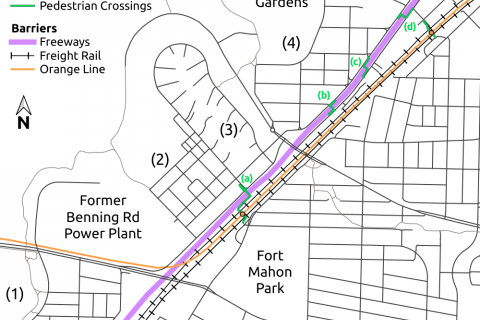
How DC Route 295 isolates neighborhoods in Northeast DC from the rest of the city
The Lane Place pedestrian overpass, which was destroyed when a truck driver collided with it last month, is one of a limited number of crossings of DC Route 295 that connect a set of neighborhoods along the Anacostia River in Northeast DC to the rest of the District of Columbia. While the bridge is slated to be replaced, the collision has highlighted the ways in which long-distance transportation infrastructure isolates these neighborhoods. Keep reading…
-

The regional transit proposals that predated Metro, from express buses to monorails
The Washington region today seems unimaginable without Metro, but the system we have today was hardly inevitable. Keep reading…
-

A look at the region’s intersections
Street networks are an important part of urban form, both for pedestrians and for public transit. Here’s a look at the region’s intersections. Keep reading…
-

These maps show how racial demographics have changed in the region since 1970
Today, the Washington region is known for having very diverse suburbs, including Prince George’s County, the largest suburban majority-African-American county in the country. However, 50 years ago, the region’s suburbs were nearly entirely white, while racial and ethnic minorities were largely concentrated in the District east of 16th Street NW. Keep reading…
-

See how the spatial distribution of education levels in the region has changed since 1970
The spatial distribution of education levels among adults in the region over the past 50 years has been similar to the distribution of wealth over the past 40 years, but there have been some notable changes over the past half-century. Keep reading…
-

A first look at our region’s new Census-Designated Places
With data collection for the 2020 Census now finished, the Census Bureau is starting to release some of the products from this once-every-ten-years project. One recent new release that is particularly significant in our region is the new Census-Designated Place (CDP) boundaries. Keep reading…
-

Here is why DC and Baltimore are different colors from space
On July 15, the crew of the International Space Station posted a nighttime photo of our region from space on Twitter, likening Washington, DC, and Baltimore to “two galaxies swirling near each other.” This photo gives us the opportunity to make a number of observations about the region. Keep reading…
-

Branch renovations and a pivot away from books: Prince George’s County libraries since 2000
The story of the Prince George’s County Memorial Library System in the 21st century is a story of renovations and replacements, and a pivot away from printed books and toward more electronic services. Keep reading…