A first look at our region’s new Census-Designated Places
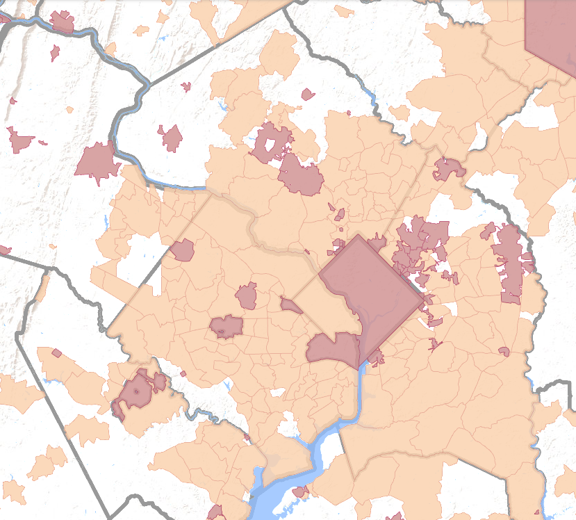
A view of our region's incorporated cities and towns (in red) and 2020 Census-designated places (in orange). With newly-established CDPs, nearly all of Fairfax County, like Prince George's County, is part of a "place" according to the Census, while much of Montgomery County's Agricultural Reserve is still not designated by the Census as places. Image by Census TIGERweb Decennial Webmap.
With data collection for the 2020 Census now finished, the Census Bureau is starting to release some of the products from this once-every-ten-years project. One recent new release that is particularly significant in our region is the new Census-Designated Place (CDP) boundaries.
Census-designated places and our region
As we’ve discussed here before, in much of Maryland and Virginia, “city government” doesn’t really exist. Cities and towns, like counties, are forms of local government created by states. States often give communities within a county their own borders and governments, “incorporating” them and leaving the county government to pass ordinances and provide services for the “unincorporated” land outside the city government. However, most of Prince George’s, Montgomery, and Fairfax Counties, and all of Arlington County, are not in any incorporated city or town, and receive all local government services from the county.
While these counties provide all the services that cities and towns provide in other parts of the country, one consequence of this system is a lack of officially-defined place names for communities in the unincorporated areas, something that can lead to geographic confusion in our region.
The fact that many communities that are not incorporated still form identifiable “places” with names that are generally recognized by the inhabitants is a problem for the Census as well. In order to tabulate demographic data for such communities, the Census Bureau defines “Census-Designated Places” (CDPs). These places are intended to be “statistical geographic entities representing closely settled, unincorporated communities that are locally recognized and identified by name.”
CDPs were first defined for the 1950 Census and, although the definitions are updated every ten years for the new Census, they are generally relatively stable. However, CDP borders are changed each Census, and occasionally new CDPs are established.
There are several things that can cause changes, including that the Census formerly required a minimum population and only “visible” boundaries, so some CDPs were established by grouping together several distinct “places,” which is now not supposed to happen. The Census has a review process, called the Participant Statistical Areas Program, that allows local governments and other organizations to review its statistical boundaries and make suggestions. CDPs have a number of requirements: for instance, they should have some amount of population, and a name should match what people in a community generally call it.
The new 2020 boundaries for Census-designated places were recently posted on the Census Bureau’s TIGERweb Decennial webmap, and a quick comparison of the 2010 and 2020 CDP boundaries shows that roughly a dozen new CDPs have been created in the DC area, mostly in Northern Virginia.
New CDPs in Fairfax County
While the entirety of Arlington County has been a single Census-designated place for decades, the 2010 Census left a sizable portion of western and southern Fairfax County outside of any CDP. The creation of eight new Census-designated places in the county, however, leaves only Dulles Airport, a narrow strip along the Occoquan River, and two small areas west of Fort Belvoir outside of any CDP. In addition, the name of one CDP has changed: mirroring the renaming of the Tysons Corner Metro station, the Tysons Corner CDP is now known simply as the Tysons CDP.
Map showing the new Braddock and Union Mill CDPs in southwestern Fairfax County. Image by Census TIGERweb Decennial Webmap.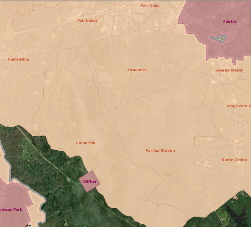
The newly-established Braddock CDP in south-central Fairfax County covers an area south of Fair Oaks and I-66 between George Mason University and Centreville. Adjacent to it is a new CDP called Union Mill that stretches from Centreville to the southeast, bordering Clifton.
Map showing the new Difficult Run and Navy CDPs in central Fairfax County. Image by Census TIGERweb Decennial Webmap.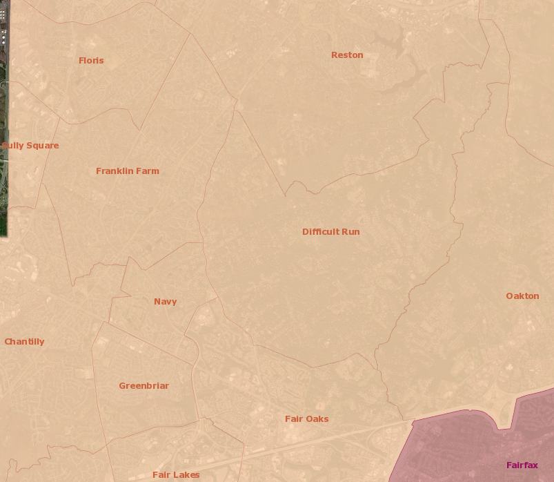
Also filling in areas in the center of the county are the new Navy and Difficult Run CDPs. Navy—I’m curious how it acquired that name—is a small area along both sides of Fairfax County Parkway just northwest of the Inova Fair Oaks Hospital. Difficult Run, on the other hand, is relatively large and consists of the very-low-density single-family home neighborhoods in the Difficult Run valley that divides Reston from Oakton and Vienna.
Map showing the new Hutchinson and Sully Square CDPs near Dulles International Airport in Fairfax County. Image by Census TIGERweb Decennial Webmap.
The new Bull Run CDP, which forms the far westernmost corner of the county, west of Centreville, is also relatively large and low density.
Map showing the new Bull Run CDP in far western Fairfax County. Image by Census TIGERweb Decennial Webmap.
On the other hand, the three remaining new CDPs are all quite small. Hutchison, nestled between the town of Herndon and the Loudoun County border at the north entrance to the Innovation Center Silver Line Phase II station, and Sully Square, a small strip of land alongside Dulles International Airport, are tiny.
Map showing the Great Falls Crossing CDP in central Fairfax County. Image by Census TIGERweb Decennial Webmap.
The final new Census-designated place in Fairfax County is a small area on the south side of Leesburg Pike / Route 7 just north of Baron Cameron Avenue.
Map showing CDPs in Loudoun County along the Fairfax County border. Image by Census TIGERweb Decennial Webmap.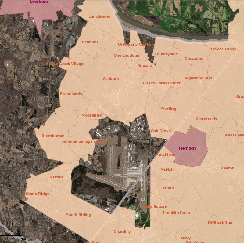
While all of Fairfax County’s new Census-designated places fill in areas that the Census did not previously consider to be “places,” the same is not true of Loudoun County. While the 2010 Census saw the establishment of a number of CDPs in southeastern Loudoun County, surrounding Dulles—there were no CDPs in the county in 2000—the new CDPs established in Loudoun County for the 2020 Census all seem, with the exception of two very small ones in the western portion of the county, to be small carve-outs from existing large CDPs.
New CDPs in Prince George’s County
Prince George’s County is almost entirely made up of incorporated places and Census-designated places. Although there are several small industrial areas and tracts of undeveloped land not included in any place by the Census, the only large such tract is the band of Federal land—the Beltsville Agricultural Research Center, the Goddard Space Flight Center, and the Patuxent Wildlife Research Center—running northeast from Greenbelt to the Patuxent River.

As such, it makes sense that the one new large CDP in the county, Brown Station, is made up of portions of two existing Census-designated places. Brown Station consists of the area between Westphalia Road and Largo Road / Route 202 south of White House Road, and is made up of rapidly-developing farmland that was formerly part of the Westphalia and Brock Hall CDPs.

The other two new CDPs in Prince George’s County consist of very small areas near the District’s eastern corner that were not previously part of any CDP. Maryland Park is the area between the cities of Capitol Heights and Seat Pleasant north of Old Central Avenue / Route 332. Cedar Heights is a tract north of Seat Pleasant, west of Fairmount Heights, and south of Sheriff Road.
New CDPs in Montgomery County
Unlike Fairfax and Prince George’s Counties, Montgomery County has a large tract of land in the northern portion of the county, mostly within the agricultural reserve, that is not part of any incorporated place or CDP.
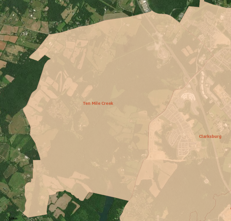
Since the Agricultural Reserve is largely off-limits to new development, it is unsurprising that most of this area has remained outside of CDPs, but one new CDP has been established in the northern portion of the county, Ten Mile Creek, just west of Clarksburg.
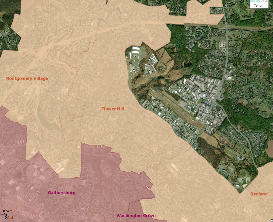
The other new Census-designated place established in a portion of Montgomery County not previously in any CDP, Flower Hill, is in the central portion of the county, between Montgomery Village CDPs and Redland CDPs, north of Gaithersburg, and between Mid-County Highway and Snouffer School Road.

Finally, a small single-family home area along Columbia Pike southwest of White Oak has been separated from the White Oak CDP as the Burnt Mills CDP.
What do you think of the new CDP names?
Do you live in or near one of the newly-established Census-designated places? Do the new CDPs make sense, and are the names familiar to you? Let us know!