Posts by DW Rowlands — Contributor

-

In Washington, not all commuting distances are created equal
Our region's wealthier neighborhoods afford their residents more, faster options for traveling around the region than poorer ones, even if the wealthier ones are farther away from the core. Keep reading…
-

Lowering fares on MARC and VRE could make Metro less crowded
Metro ridership is still pretty high despite all of the system's issues. Lowering fares on commuter rail systems like MARC and VRE could help ease Metro overcrowding. Keep reading…
-
_480_320_90_s_c1.jpg)
It’s part streetcar, part bus, and it ran in Arlington and Fairfax in the 1930s
The Rosslyn-Ballston corridor is a famous example of early transit-oriented development because of the Orange Line, but the area was home to an innovative transit experiment long before Metro. From 1936 through 1939, a streetcar-bus hybrid provided service from the City of Fairfax to Rosslyn and into DC. Keep reading…
-

If Republicans crippled the Census, we’d all be more ignorant
Since Donald Trump took office, there has been a lot of concern about his administration restricting government agencies from collecting and publishing data. Now, Congress is pushing to keep federal dollars from being used to collect data about housing and racial disparities in the US. Is this a precursor to an attack on one of the most important functions of the United States Census? Keep reading…
-

See how long it takes to get from each Metro station to the downtown core
Like most American rail transit systems, Metrorail is arranged in a way that sends most trips toward a cluster of downtown stations where the lines converge. I made a map to show how long it takes to travel from each station to the system's downtown core. Keep reading…
-

Langley Park’s new transit center opened on Thursday!
A major new bus station opened in Prince George's County on Thursday. Located at the intersection of New Hampshire Avenue and University Boulevard on the Montgomery County border, the long-awaited Takoma-Langley Crossroads Transit Center will make taking the bus through the area— and, in particular, transferring between buses— far easier and safer. Keep reading…
-
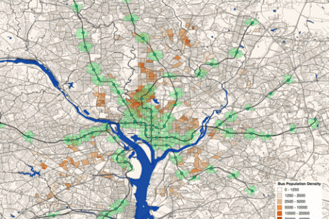
This map shows where the most bus riders live and how close they are to Metro
High population densities are generally considered necessary for frequent and direct bus service. However, not all dense populations have high bus ridership. I recently created a map of the population density of people who commute to work by bus in the DC area. Keep reading…
-

Maps of where our region’s jobs are, what types of jobs they are, and what they pay
When we talk about the densities of neighborhoods, there is a tendency to focus on how many people live in an area. But it can be equally important to talk about how many jobs are there, and what types. The maps below show where the jobs in our region are as well as how much they pay. Keep reading…
-
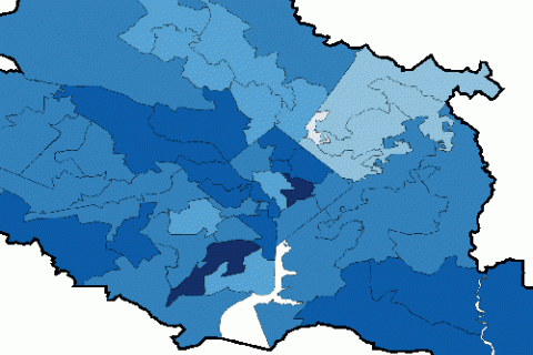
This map shows what percentage of our region’s population is registered to vote
Most of us have at least a vague understanding of the political leanings of the communities we live in, but we tend not to know what fraction of our neighbors actually vote. I recently made a map showing what fraction of the population is registered to vote in legislative districts throughout the region. Keep reading…
-

This square in Philadelphia is everything DC’s Franklin Square could be
Many celebrate Philadelphia’s Rittenhouse Square as one of America’s best small urban parks. I visited this summer and found it alive with activity. It’s a great model for DC’s similarly-sized Franklin Square, which the National Park Service is currently redesigning. Keep reading…