This map shows where the most bus riders live and how close they are to Metro
High population densities are generally considered necessary for frequent and direct bus service. However, not all dense populations have high bus ridership. I recently created a map of the population density of people who commute to work by bus in the DC area.
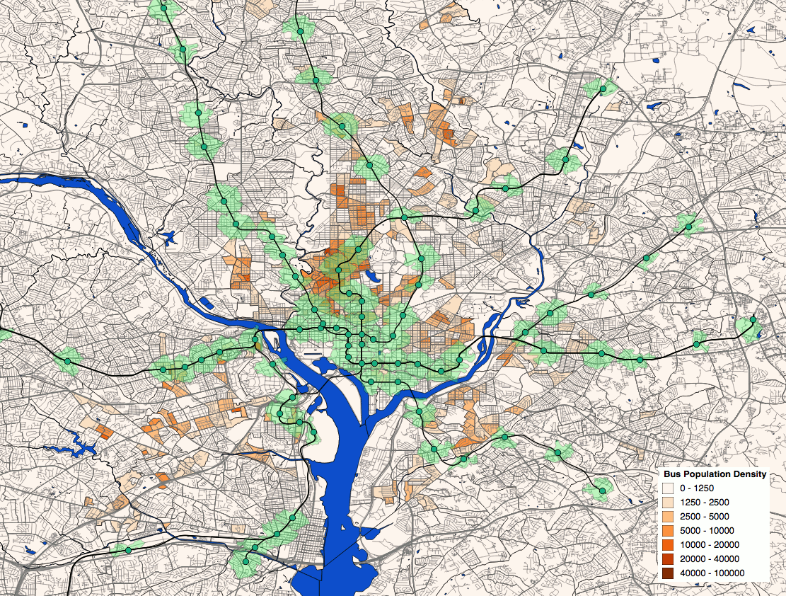
This map shows the density of people in the region who reported that the longest part of their commute was by bus. The green regions around Metro stations are half-mile walksheds. The darker the red color in the census tract, the more people there take the bus.
To create the map, I used the Census’s 2014 American Community Survey’s data on how many people in each census block group reported that they made the longest part of their commute to work by bus. It’s important to recognize some limitations to this data: in particular, it completely excludes non-working individuals who still make many or most trips by bus. Furthermore, it excludes anyone who uses a bus to get to a Metro station that’s too far to walk, and then uses Metrorail for a longer trip to their job.
In addition to the ACS data, I plotted half-mile walksheds around Metrorail stations, using a GIS shapefile provided by WMATA’s PlanItMetro blog back in 2014 (unfortunately, this shapefile predates the Silver Line and so doesn’t have walksheds for those stations). These walksheds allow us to compare areas of high bus ridership to the areas in which residents have a reasonably short walk to a Metro station.
In some places, lots of people take the bus even though they live near Metrorail
It is interesting to note that some of the highest bus-rider densities in the area are in DC’s Mid-City, the neighborhoods from Shaw to Petworth that are in the vicinity of Green and Yellow Line stations. It is likely that these area’s proximity to downtown and the fact that they are served by very frequent bus routes (the 14th Street, 16th Street, and Georgia Avenue lines) makes the bus a more convenient, as well as cheaper, alternative to Metrorail.
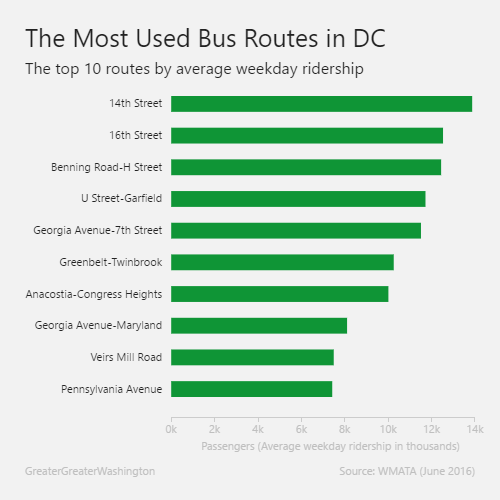
Chart by Dan Henebery.
But more predictably, most big groups of bus riders don’t live near Metrorail
Unsurprisingly, the high density of bus riders along the Silver Spring-to-downtown Metrobus lines continues north of the Georgia Avenue-Petworth station, where the corridor is not served by rail. As can be seen in the above chart, the 14th Street and 16th Street lines are Metro’s busiest bus lines, and the Georgia Avenue line is its fifth-busiest.
Other than in Mid-City, though, the areas of highest bus rider density tend to be in corridors that are not well served by Metrorail. Within the District, high densities of bus riders can be found along the H Street-Benning Road line— Metro’s third-highest-ridership bus line— in the largest area of the original L’Enfant City without Metrorail service.
Like bus riders in the northern Georgia Avenue/14th Street corridor, many of the bus riders East of the River live in areas not well served by Metrorail. A cluster of bus-riders on Massachusetts Avenue in the vicinity of American University is also some distance from Metro stations. The lack of major bus routes in this area suggests to me that they are mostly students riding university shuttles.
Outside of the District, lower population densities, a less transit-friendly built environment, and less-frequent bus service naturally leads to lower population densities of bus riders. However, high densities of bus riders are found along the Columbia Pike corridor in southern Arlington County, which has been the site of proposed rail lines since the original laying-out of Metro.
The Langley Park area, at the intersection of New Hampshire Avenue and University Boulevard on the border between Prince George’s and Montgomery Counties is also home to a large cluster of bus riders. Metro’s sixth-highest-ridership bus route, the circumfrential Greenbelt-Twinbrook line, runs along University Boulevard in this area, which is also served by a number of other Metrobus and RideOn bus routes. The new Takoma-Langley Transit Center, serving these routes, is scheduled to open at the University Boulevard/New Hampshire Avenue intersection in the next several months, and the area is also slated to be home to several Purple Line stations.
It is interesting to note that the White Oak/Calverton area, at the intersection of Columbia Pike and New Hampshire Avenue in eastern Montgomery County, is home to perhaps the highest density of bus riders outside the Beltway. This area is also an employment center, with the FDA’s White Oak research campus on the site of the old Navy Surface Warfare Center.