Segregation and the rise of the car shaped DC’s “new downtown”

Aerial of Downtown DC in 1980, facing west down Massachusetts Ave and K Street NW by Carol M. Highsmith, Library of Congress.
This article is the second in a three-part series about the history of downtown DC. Read Part 1 and Part 3
Despite George Washington and Pierre L’Enfant’s intention that the new capital city would have its center on the plateau between Capitol Hill and the Anacostia River, the 19th century saw downtown Washington develop in the area just east of the White House. Despite the massive growth of Federal office space during the first half of the 20th Century, the commercial core remained centered in the “old downtown” east of the White House until the 1950s, when it began to migrate to a “new downtown” north and west of the White House.
The postwar years and a “new downtown”
As late as 1950, large office buildings were primarily found in the “old” downtown east of the White House and in the Federal Triangle and Northwest Rectangle (Foggy Bottom) government complexes, as seen in the aerial photo below. However, this soon began to change. Much of Southwest DC was demolished in the 1950s as part of a massive urban renewal project, and the area between the Mall and F Street SW (now the Southwest Freeway) was filled with Brutalist government office buildings.
This 1950 photo of downtown Washington from an Air Force bomber shows that large buildings were still much more prevalent east than west or north of the White House. Image by the Library of Congress.
During the World Wars and the New Deal, the Federal government, and the Federal workforce in Washington, had grown substantially, and new offices were built in areas beyond the limits of downtown — Federal Triangle, the Northwest Rectangle, Southwest DC, and even the Mall — because they were either empty or their existing built environments could be characterized as “slums” and cheaply condemned and replaced with new office buildings. The traditional downtown area east of the White House, however, had remained largely untouched, and remained home to large department stores and private-sector office buildings.
The central business district of Washington, DC, as defined by the 1963 Economic Census. It is bounded to the north by Massachusetts Avenue, the south by the Mall, the west by 18th Street, and the east by 5th and 6th Streets. It contains both the "old" and the "new" downtown areas, but excludes Judiciary Square. Image by the US Census Bureau.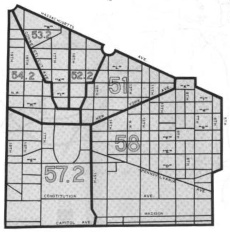
Although the Barr Building, the first office building built on Farragut Square, opened in 1927, the area west of 16th Street had remained largely residential for decades until a number of new office buildings opened in the mid-1950s. By the mid-1960s, Farragut Square was nearly entirely surrounded by large office buildings and office construction was spreading west along K Street and north along Connecticut Avenue. This “new downtown” area — included in the 1963 Census Bureau map of Washington’s central business district above — also began to attract much of the high-end retail that had previously been found on F and G Streets east of the White House as the large number of office workers in the new buildings provided a lunchtime shopping clientele.
Streetcars and Automobiles
Why did the commercial core of DC shift after remaining centered east of the White House for over a century? Part of the answer can be found in transportation. For most of the 19th century, downtown DC — like all downtowns in the era when most urbanites commuted on foot — was a live-work community, with a large residential population living near their jobs. The growth of the District’s streetcar network after the Civil War, however, made it possible for workers to commute from the new residential areas being built in previously-rural parts of the District just as the rapid growth of the capital city — from 75,000 District residents in 1860 to 280,000 in 1900 — increased demand for office space downtown.
By the early 20th century, downtown had lost most of its residents, as office space displaced residential uses. However, the District’s streetcar network was strongly centered on the downtown area, which continued to make it the most in-demand location for both office space and retailers. Even before World War II, though, the rise of the automobile began to make downtown locations less appealing.
By 1924, congestion in downtown had already become serious enough that the DC traffic bureau considered plans to convert Franklin Square into a parking lot and widening K Street NW from 14th to 16th Streets to allow parking in a center median. Although these plans were never enacted, in 1938, the present-day service lanes along K Street NW between Connecticut Avenue and 12th Street NW were carved out of what had been a portion of the sidewalk in order to turn the road into a major east-west thoroughfare. (The service lanes were extended west to 25th Street in 1962.)
While a location as close to the core of the streetcar network was ideal for workers and shoppers who used public transit, automobile commuters preferred less-crowded areas with more parking. In 1942, Congress created the DC Motor Vehicle Parking Agency, which bought up land in the areas adjacent to, but outside of, the “old” downtown for public parking lots, making these areas more appealing than core itself to automobile commuters. The surge of office construction in the “new” downtown in the 1950s and 1960s was partly fed by these public parking lots but, as it replaced surface parking with buildings, it spread the parking crunch northwest, leading to a 1961 proposal to build a large underground parking garage beneath Farragut Square.
Segregation and Suburbanization
The growth of car commuting to jobs in downtown DC went hand-in-hand with the suburbanization of the metro area’s population. In 1940, 68% of the metro area’s population lived in the District, and these District residents overwhelmingly commuted to downtown jobs by public transportation. However, those who did commute to downtown mostly drove: the District’s streetcar network did not serve suburban jurisdictions well and automobile congestion slowed buses and streetcars running in mixed traffic from the suburbs.
| 1920 | 1930 | 1940 | 1950 | 1960 | 1970 | |
|---|---|---|---|---|---|---|
| District of Columbia | 76% | 73% | 68% | 55% | 38% | 28% |
| Northern Virginia | 6% | 11% | 14% | 21% | 27% | 27% |
| Prince George’s County | 8% | 9% | 9% | 13% | 18% | 25% |
| Montgomery County | 6% | 7% | 9% | 11% | 17% | 20% |
After World War II, the suburban share of the metro area population skyrocketed: by the 1950 Census, 45% of the region’s population lived in the suburbs; by 1960, 58% of the population did, and and by 1970, 72% of the population lived in suburban jurisdictions. These suburban commuters largely got to their jobs — whether downtown or in the suburbs — by car, so downtown office locations closer to the Whitehurst Freeway (opened 1949) and Rock Creek Parkway (opened 1938), which connected to some of the region’s richest suburbs, were preferred.
Segregation and the racial make-up of neighborhoods near downtown also played a role in the move of downtown offices to the northwest. As shown in the map below, redlining and disinvestment had resulted in the neighborhoods to the northeast of Massachusetts Avenue bordering on the “old” downtown being nearly entirely Black. Meanwhile, the neighborhoods west of Rock Creek Park that the the Connecticut Avenue and K Street thoroughfares of the “new” downtown led to were nearly exclusively white as a result of restrictive covenants on the subdivisions built along the Connecticut Avenue and Wisconsin Avenue streetcar lines, as well as the District government’s razing of the thriving Black neighborhood of Fort Reno in the 1920s and other racist maneuverings.
A racial dot map showing population distribution in 1970: the population north of the "old downtown" area was largely Black, while the area adjacent to the "new downtown" was predominantly white. Image by the author.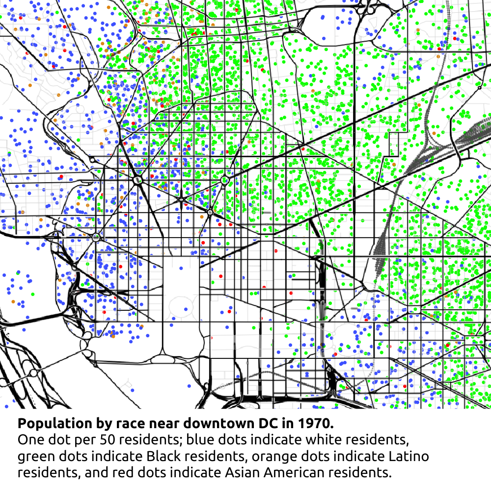
The riots that engulfed many of the majority-Black neighborhoods of Washington in the wake of the April 1968 assassination of Martin Luther King, Jr. played a major role in the decline of the “old” downtown area east of the White House. Fires, looting, and violence engulfed the areas just north of Massachusetts Avenue, and blocks of stores were destroyed along the 7th Street NW commerical corridor just north of Mount Vernon Square. Although relatively little of the destruction occured in downtown proper, it led to a mass-exodus of businesses from the areas of downtown adjacent to the predominantly-Black neigbhorhoods north of Massachusetts Avenue. By the early 1970s, much of the commercial property in the “old” downtown was either empty or occupied by businesses, such as pornographic bookstores and theatres, that were perceived as “sleazy” and drove further abandonment of the commercial district.
Redevelopment of “old” downtown
Many of America’s downtowns never really recovered from the period of suburbanization, freeway-building, and divestment that struck urban cores during the decades from 1950 to 1990. Although they still exist, a quarter to a third of their land is devoted to parking lots and garages (compared to 3% in DC) and they are often home to less than 10% of a region’s jobs (compared to 15% in DC). That downtown DC is one of the largest and densest central business districts in the country is a story of successful rebirth, but also a consequence of the city managing to avoid some of the worst excesses of urban renewal.
This map map based on the 1958 "Basic Freeway Plan" for DC shows plans for an "inner ring" that would've surrounded downtown while wiping out much of the U Street Corridor. 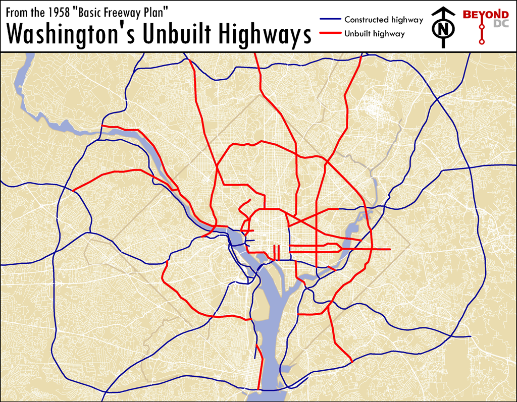
In the 1950s planners proposed a massive freeway system for the region, including an “inner ring” that would have surrounded downtown DC and would have involved the destruction of some of the District’s densest residential neighborhoods. Fortunately, unlike in many US cities, only a small portion of this plan came to fruition. The Southeast/Southwest Freeway was constructed along what had been F Street SE and SW, as was DC Route 295 and the I-395 spur that runs between 2nd and 3rd Streets NW. Likewise, most of Southwest was demolished, driving out the majority of its largely-Black residents and small businessess, and was replaced by lower-density housing and a more car-oriented street grid. However, the northern portion of the inner ring freeway was never built, and the residential neighborhoods directly adjoining downtown to the north avoided the fate of Southwest.
The National Capital Planning Commission's 1969 Downtown Urban Renewal plan covered the entire area between 3rd and 16th Streets NW south of M Street NW and north of Pennsylvania Avenue. Image by the National Capital Planning Commission.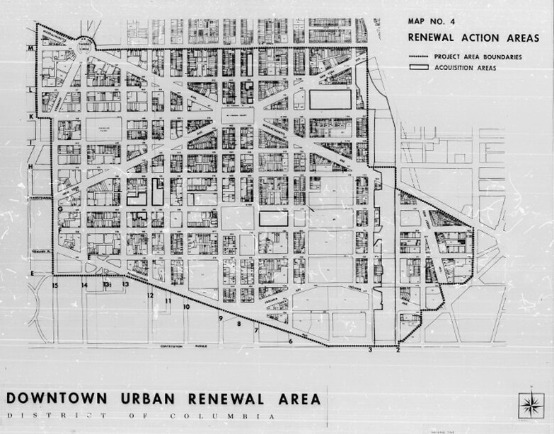
While a number of redevelopment plans for the “old” downtown area of DC were developed in the 1960s and 1970s, culminating in the 1972 creation of the Pennsylvania Avenue Development Corporation, these plans were implemented alongside—and taking into account—the simultanious construction of Metro as a regional rapid transit system intended to bring suburban workers to the urban core. Two of the three main downtown transfer stations, Gallery Place and Metro Center, were located in the “old” downtown, and played a role in helping to revive it as a business and commercial district, though the largest concentration of jobs has remained relatively far west, centered on Metro Center and Farragut Square, while the neighborhood around Gallery Place is more residential and entertainment-oriented, and anchored by the Capital One Arena, which opened in 1997.
Although downtown DC, both east and west of 16th Street, as been one of the national success stories of a central business district surviving the suburbanization and urban disinvestment of the last century, today it is struggling with a new challenge: the rise of remote work in the aftermath of the COVID-19 pandemic. According to 2021 American Community Survey data, the DC region has one of the highest rates of teleworking in the country, contributing to a drop in the share of the region’s workforce working downtown, and in the District overall.
Notes on Sources:
The National Register of Historic Places application for the Barr Building provides a useful history of office building development on Farragut Square. Other sources on office construction in the “New Downtown” during the 1950s and 1960s include “New Connecticut Avenue Office Building Planned” (The Washington Post, 4 December 1955, page G5), “New Downtown Building Slated for Construction” (The Washington Post, 3 August 1956, page 31), “Connecticut Avenue Office Building 75% Leased” (The Washington Post, 30 March 1957), “New Downtown Offices Under Construction” (The Washington Post, 25 April 1959, page B5), and “Office Buildings are Encircling Farragut Square” (John B. Williams, The Washington Post, 20 April 1963, page C1).
The transition of retail from the “old” to the “new” downtown is discussed in “New Connecticut Ave. Visioned by Architect” (Jerry Doolittle, The Washington Post, 29 January 1964), “Raleighs Sets New Locations” (The Washington Post, 11 December 1969, page C12), and “Demise of Downtown Feared by Investors” (Claudia Levy and Eugene L. Meyer, The Washington Post, 5 April 1971, page C1). The latter also discusses how the aftermath of the 1968 riots led to a businesses leaving the “old” downtown area.
My sources on the proposal to convert Franklin Square to a parking lot are “Widening K Street, Franklin Square as Auto Park Planned” (The Washington Post, 6 August 1924, page 1) and “Protests Kill Plan to Make Auto Park of Franklin Square” (The Washington Post, 7 August 1924, page 2).
My sources on the pre-World War II widening of K Street are “New Lanes on K Street are Planned” (The Washington Post, 5 August 1937, page 15) and “K St. Widening Tomorrow Not to Halt Traffic” (The Washington Post, 6 July 1938, page 2). “Dealers Hope Western Market Survives K Street ‘Renewal’” (The Washington Post, 18 July 1962, page C1) and “The Sidewalk Yields to the Street” (The Washington Post, 15 August 1962, page B6) discuss the extension of the K Street NW service lanes from Connecticut Avenue to 25th Street.
My sources on downtown parking in the 1950s and 1960s are “Farragut Square Underground Plan Torpedoed by Private Operators” (Laurence Stren and Leslie H. Whitten, The Washington Post, 21 August 1962, page A1), “‘Private Enterprise’ Destroyed Grand Design for Mid-City System” (Laurence Stern and Leslie H. Whitten, The Washington Post, 22 August 1962, page B1), and “Urban Renewal is Principal Target of Parking Clique” (Laurence Stern and Leslie H. Whitten, The Washington Post, 23 August 1962, page B1).