DC’s downtown wasn’t supposed to be where it is. Here’s how it migrated

This could have been an image of DC’s downtown, if downtown had developed in the way L’Enfant envisioned it. by CTB in DC used with permission.
This article is the first in a three-part series about the history of downtown DC. Read Part 2 and Part 3.
For the past century, DC’s downtown has been associated with areas around the White House — but that wasn’t the original plan. When George Washington and Pierre L’Enfant laid out designs for the new capital in the late 1700s, they envisioned a very different city, with a commercial core east of the Capitol building stretching to the Anacostia River.
The pair planned the District’s downtown this way in order to connect to the wharves on the Anacostia, which they expected to become a major port. However, that’s not how the city ultimately evolved. Let’s learn how downtown DC migrated over a mile to the north and west from this initial plan to its current location.
Did you know downtown DC was supposed to be where Eastern Market is?
Today, Capitol Hill consists largely of residential townhomes, while DC’s commercial core is firmly west of the Capitol. When George Washington selected the site for the federal district however, he included the existing Potomac River ports of Georgetown and Alexandria, but intended the new capital city to stretch east and southeast from Jenkin’s Hill (now Capitol Hill) down to docks on the Anacostia. There, ships would be protected from ice flows that often came down the Potomac during spring thaws, and sometimes damaged ships docked at Georgetown.
This 1846 daguerreotype of the East Front of the Capitol by John Plumbe shows the original ceremonial entrance to the building from East Capitol Street. Image by the Library of Congress.
The East Front of the Capitol was designed to be its formal entrance for receiving dignitaries, based on this assumption that the new capital city would face the Anacostia and East Capitol Street would be a grand avenue connecting the East Front of the Capitol to a bridge across the Anacostia. In reality, the East Capitol Street bridge was not built until 1955. Likewise, while the current Zero Milestone is located at the north edge of the Ellipse, L’Enfant’s plan indicated that a column from which “all distances of places through the continent are to be calculated” would be placed in what is now Lincoln Park at 12th Street and East Capitol Street.
A general Anacostia-ward orientation of Washington seems to have existed for a few years, with Barracks Row on 8th Street SE built as the city’s first commercial corridor before the War of 1812. Although the streets east of the Capitol largely developed into residential neighborhoods, they retain the same wide rights-of-way as streets west of the Capitol, including a 160-foot right-of-way for East Capitol Street, which L’Enfant intended to be lined with embassies.
By the late 19th century, Congress recognized that it was unlikely that the wide rights-of-way east of the Capitol would be needed, or paved. In 1899, landowners were authorized to fence in a portion of the public right-of-way to use as front yards, so long as the land (which remained public property) was maintained as a garden or lawn and fences were low. Notably, the land that makes up these front yards cannot be used for parking vehicles.
Penn Quarter: DC’s 19th Century downtown
Washington never became a major port town, despite L’Enfant and Washington’s hopes and efforts such as the incomplete Chesapeake and Ohio Canal, which opened in 1831 but never made it west of Cumberland, Maryland.
There were numerous reasons for this. The Anacostia became silted due to deforestation and intensive tobacco cultivation in its watershed, and the development of railroads reduced the value of a port a hundred miles up the Potomac from the Chesapeake. When the city was rebuilt after the British burned it during the War of 1812, it centered on the sections of Pennsylvania Avenue and F Street directly east of the White House.
This view of downtown DC from the 1878 Hopkins Atlas of Fifteen Miles Around Washington shows that public buildings and the core of the streetcar network were clustered in the area between the White House and North Capitol Street. Image by the Library of Congress.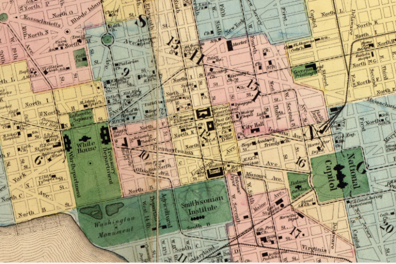
The earliest executive branch office buildings were built adjacent to the White House for the departments of the Treasury, War, State, and Navy. However, other early government buildings, including the Old Patent Office Building (1836) — which now houses the National Portrait Gallery and the Smithsonian Museum of American Art — the General Post Office (1839) — which now houses the Hotel Monaco — and the Pension Building (1887) — now the National Building Museum — were built east of the White House along F Street.
The Old City Hall (1820) — now the DC Court of Appeals — and the original Willard Hotel (1847) were also built in this area, and formed the core of the streetcar network that began to develop during the Civil War.
This 1894 map shows the locations of street lamps in downtown Washington, DC. Electric lamps — the largest dots — line both sides of Pennsylvania Avenue between the Capitol and White House, F Street east of the White House, and 7th Street NW. They also line one side of Pennsylvania Avenue west of the White House and East of the Capitol, 14th Street NW, and portions of 9th Street NW and E Street NW in the old downtown area. Image by the Library of Congress.
F Street east of the White House and 7th Street NW became major shopping districts after the Civil War, and remained so through the first half of the 20th century.
As shown in the 1894 map of electric street lamp locations above, only the section of Pennsylvania Avenue between the Capitol and White House, the 7th Street NW corridor, and the portion of F Street east of the White House were initially considered important enough to receive electric lamps on both sides of the street.
Areas north and west of the White House, plus the area between Judiciary Square and the Capitol, were largely residential at this time.
World wars and a growing federal government
Into the first half of the 20th century, the area between the White House and North Capitol Street remained DC’s downtown core, as seen in the 1929 map of building footprints below.
The area bounded by New York Avenue, Massachusetts Avenue, New Jersey Avenue, and the National Mall was the most built-up, with many blocks entirely filled in with buildings. The K Street Corridor and the area between Farragut Square and Dupont Circle — now some of the District’s densest office real estate — consisted of blocks of row houses with large unbuilt areas in their centers.
This 1929 USGS map of downtown Washington shows that blocks east of the White House and south of K Street and Massachusetts Avenue covered nearly their entire lots, while those to the north and west of the White House covered much less. Image by the Library of Congress.
The 1929 map also shows a number of temporary buildings on the National Mall, built during World War I, as well as the 1867 Department of Agriculture Building, which was demolished the next year. Several federal buildings that still exist today were also built south of the Mall in the first decades of the 20th century: the current Department of Agriculture headquarters (1908) and the Bureau of Engraving and Printing (1914).
Shortly after World War I, planning began for the clearance of the “Murder Bay” industrial area south of Pennsylvania Avenue — which had been home to utility companies, stables for horse taxis, and a lumberyard, as well as the 19th century Center Market — in order to construct the Federal Triangle office complex.
The federal policy of building government offices on top of cleared “slums” continued during the Franklin D. Roosevelt administration. Between 1934 and 1944, the Alley Dwelling Authority removed residents of the Foggy Bottom neighborhood and replaced them with “Northwest Rectangle” federal offices west of the White House between E Street and Constitution Avenue.
Rapid expansion of the federal workforce during the New Deal and then World War II again led to the construction of numerous temporary office buildings, the largest of which were located on the Mall, but several of which were located south of it. There were also a number of them in the downtown area, the Northwest Rectangle, and south of Independence Avenue.
A map of job locations in 1944. Bars on the left represent commuters from outside the District; those on the right represent commuters from within the District. From the Transportation Survey and Plan for the Central Area of Washington, D.C., J.E. Greiner Company and De Leuw, Cather & Company Consulting Engineers, 1944. Image by the author.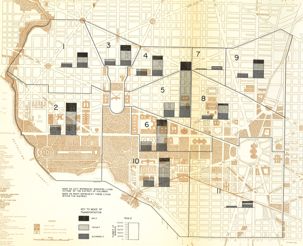
As seen in the above 1944 map of worker locations, produced as part of the transportation study that proposed a large streetcar subway network, the majority of the roughly 200,000 workers in DC’s core during World War II were located in the historic downtown area between the White House and 7th Street NW, the Northwest Rectangle and Federal Triangle, and in the area just south of the Mall and west of 7th Street NW.
Up to that point, less than 15% of the workers in the core of DC were located north and west of the White House, but that would rapidly change over the next two decades.
Notes on Sources:
My source on George Washington’s original thinking on the site of the capital city comes from pages 38-41 of Political Terrain: Washington, D.C. from Tidewater Town to Global Metropolis, by Carl Abbott.
When L’Enfant drew up the plan for Washington, there were no bridges across the Anacostia within the District of Columbia, only two ferries: the “Upper Ferry” on the turnpike to Upper Marlboro, now Pennsylvania Avenue SE, and the “Lower Ferry” from what is now New Jersey Avenue SE to Poplar Point.
L’Enfant’s plan showed a drawbridge at the site of the Upper Ferry, and a bridge on East Capitol Street. In actuality, three bridges were built across the Anacostia in early 19th Century: the 1804 Eastern Branch Bridge built near the site of the current Sousa Bridge on Pennsylvania Avenue SE, Stoddert’s Bridge in 1805 on the location of the current Benning Road Bridge, and the 1820 Upper Navy Ard Bridge built at the site of the current 11th Street Bridge.