A 1944 proposal for a DC streetcar subway would have been the largest in the US

Image from the 1944 Transportation Survey and Plan for the Central Area of Washington, DC.
This article was first published on May 9, 2019. We love to look back at what could have been in the region — especially with transit — and wanted to share this piece with you again.
A swelling population in the District between the late 1930s and the early 1940s resulted in a lot of traffic congestion—as well as calls to fix it. Many officials and companies were excited about the prospect of building a subway system, and some of them proposed truly ambitious plans.
Several proposals were written to address the District’s needs. Although DC Director of Highways Herbert Whitehurst put forward a system that did not include a subway, a 1944 follow-up study by J.E. Greiner Company did propose an extensive seven-mile streetcar subway system.
A map of proposed streetcar routes through downtown DC using the proposed three-tunnel streetcar subway system. From the Transportation Survey and Plan for the Central Area of Washington, D.C., J.E. Greiner Company and De Leuw, Cather & Company Consulting Engineers, 1944. Image by District Department of Transportation.
Plans for a streetcar subway twice as long as other US systems
Under the J.E. Greiner Company’s plan, the District would build:
- A 3.1-mile Connecticut Avenue-G Street subway that would have followed very nearly the same route the Red Line does today between Dupont Circle and Union Station, with intermediate stops at N, L, and Eye Streets on Connecticut Avenue and 15th, 14th, 11th, 7th, 4th, and 1st Streets on G Street.
- A 2.7-mile Pennsylvania Avenue subway bearing some similarity to the Orange, Blue and Silver lines between Farragut West and Capitol South. It would have run from just northwest of the White House along Pennsylvania Avenue to 5th Street, cross the Mall, and then run on Independence Avenue to 2nd Street SE. Intermediate stops were planned at 15th, 14th, 13th, 10th, 7th, and 5th Streets north of the Mall and 3rd Street NW and 1st Street NE south of the Mall.
- A 1.3-mile 14th Street subway that would have run from Thomas Circle to the underground terminal at the Bureau of Engraving and Printing that had opened in 1943, with intermediate stops between K and L Streets, H and Eye Streets, F and G streets, and at D Street and at Constitution Avenue. The automobile tunnel carrying Massachusetts Avenue under Thomas Circle (opened in 1940) meant that extending this line further north would have required deep-bore tunneling.
While this streetcar subway system would have been much smaller than the Metrorail system that was eventually built, it is worth noting just how ambitious a plan it was. Had it been built, it would have given Washington a streetcar subway system twice as long as any of the others in the US at that time.
In 1944, Boston had the longest streetcar subway in the country, with a 2.5-mile line completed in 1932 and a one-mile branch added in 1941. Philadelphia had a subway which took streetcars from the west of the city to a downtown loop, but it was just under a mile. And the Newark and Rochester streetcar subways, which were built in old canal beds, each involved less than two miles of underground track.
The J.E. Greiner Company’s system would have been top-notch
The three proposed subway lines were designed to be built to very high standards. There would be no track-sharing between lines. The transfer station between the Pennsylvania Avenue and Connecticut Avenue-G Street lines would have four tracks and two platforms connected by a mezzanine, while the 14th Street line would have transfers to the other two lines with two-level crossing stations much like (though smaller than) Metrorail’s downtown transfer stations.
The stations on Pennsylvania Avenue were supposed to have mezzanines because of the road’s width, and all stations with mezzanines would get elevators. However—unlike Metro—stations were intended to be as close to the surface as possible, so most stations didn’t have mezzanines. Passengers would have had to enter the station on the side of the street corresponding to the direction they wanted to go.
The system was also designed for high levels of service. Platforms were 300 feet long—long enough for six streetcars—and stations would have fare gates so that boarding wouldn’t be slowed by passengers having to pay. It proposed a more expensive flying junction for the turnback loop on the Pennsylvania Avenue line just south of the Capitol, so that streetcars turning back there would not need to cross the opposite-direction track at-grade.
The estimated cost of the three lines was $56 million, or about $800 million today. The authors of the report justified the expense of such a large project by arguing that streetcars were the natural backbone of the District’s public transit network, since diesel buses were slow to accelerate and had low capacities and trolley buses were impractical because of the ban on overhead wires downtown.
The authors intended for streetcar service through the new tunnels to be operated by Capital Transit, the company that operated the District’s other bus and streetcar service. They argued that the tunnels should be publicly funded and owned because they would benefit passengers, motorists, downtown businesses, and the federal government, rather than just the streetcar company.
A pared-down 1946 proposal
Unfortunately, while the original proposal for streetcar subways was quite ambitious, it was quickly scaled down. A follow-up report on transportation in the District, produced by the same engineering company as the 1944 report, proposed a significantly shorter system. In the proposal:
- The Conncecticut Avenue-G Street line was truncated to a line along F Street from Lafayette Park to 7th Street. No tunnels along Connecticut Avenue were proposed except for the actually-built Dupont Circle tunnels. However, a streetcar tunnel along H Street under New York Avenue had been added, and an underground streetcar station Union Station is retained.
- The Pennsylvania Avenue line now only ran from 18th Street to 7th Street, and did so under Pennsylvania Avenue for its whole length. A tunnel carried the 7th Street streetcars under the Mall, but it appears not to have any intermediate stations, and it was to cross the Mall in an open cut to reduce construction costs.
- The 14th Street line was unchanged, except that it is also crossed the Mall in an open cut to save on construction costs.
By 1946, the proposed extent of the streetcar subway lines was significantly reduced but a streetcar tunnel under the Mall along 7th Street was proposed. The thickness of the black arrows indicate estimated streetcars per hour at evening rush hour. From Transportation Plans for Washington, J.E. Greiner Company and De Leuw, Cather & Company Consulting Engineers, 1946. Image by District Deparment of Transportation.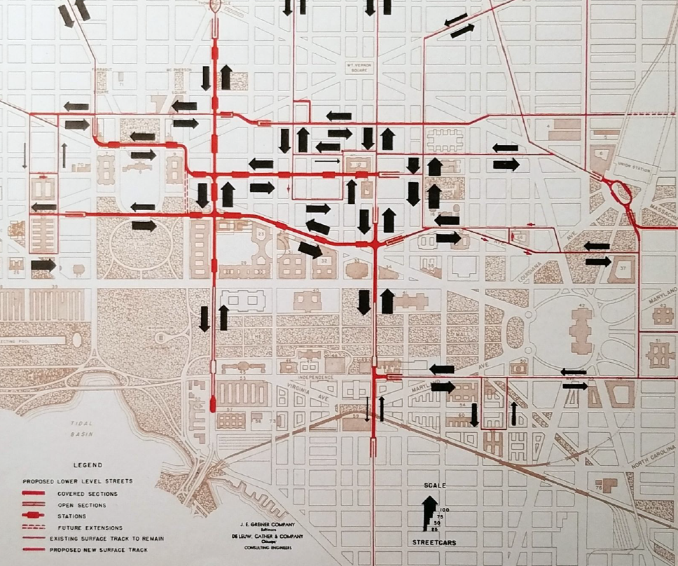
This shorter system, which would not include mezzanine stations or grade separations between crossing streetcar lines, was estimated to cost $34 million—just less than two-thirds the cost of the 1944 proposal.
In addition to concerns about construction costs, the 1946 report notes that there were numerous complaints that the originally-proposed system had overly-long spacing between stations, that it required too much simplification of the downtown streetcar network and thus too many transfers, and that the mezzanine stations were too far underground.
The 1946 report suggested that construction of the system begin by 1950. However, by spring 1947 it was already facing heavy opposition. Both Capital Transit and the National Capital Parks and Planning Commission opposed constructing subways based on the belief that they would be “too rigid” to adjust service to changing population and traffic conditions.
By 1948, the plan was essentially dead, killed by this opposition and concern about the District’s backlog of other unmet transportation needs.
The 1944 plan offers a blueprint for better bus service today
The shorter tunnels proposed in 1946 would have maintained connections to nearly all existing surface streetcar tracks so that routes would not need to be simplified. More segments that ran on the street would allow streetcars to continue to stop for every streetcar line, as before.
It is worth noting, however, that the stations in the 1944 proposal were separated by roughly half the distance as Metro stations downtown are today. There’s roughly one station every quarter mile, which is approximately the spacing modern planners usually recommend between bus stops. Likewise, a simpler streetcar network with transfers between a few frequent lines—rather than retaining the more complex but lower-frequency routings used by the District’s streetcars and, today, its buses—is more in line with modern transit planning doctrine.
While Metro has made bus tunnels under downtown unnecessary, it may make sense to redesign downtown bus service to be more in line with the streetcar service contemplated in the 1944 plan.
This is Part III of a series of three articles. Read Part I and Part II.
Sources:
The basic primary sources for this article are three reports on the possibility of subways in DC, all produced in the 1940s. I acquired a PDF scan of the 1942 report (minus figures) from the National Archives, and a PDF scan of the 1946 report from a friend. I was able to view the 1944 report in hardcopy at the DDOT Archives and some high-quality scans of its figures are posted online on their website.
- Report of a Preliminary Survey to Determine the Feasibility of the Construction of Subways in the District of Columbia for both Streetcar and Vehicular Traffic, District of Columbia Department of Highways, 1942.
- Transportation Survey and Plan for the Central Area of Washington, D.C., J.E. Greiner Company and De Leuw, Cather & Company Consulting Engineers, 1944.
- Transportation Plans for Washington, J.E. Greiner Company and De Leuw, Cather & Company Consulting Engineers, 1946.
In addition, a number of Washington Post articles from the 1940s gave me background on the history behind these reports and why they were made.
- “How U.S. Employes [sic] Get To Their Work,” Washington Post page 6, April 25, 1941.
- “D.C. Subway Is Predicted By Van Duzer,” Washington Post page 19, April 8, 1941.
- “Public Hearing On Traffic Plan Set for May 20,” Washington Post page 17, April 29, 1941.
- “Hearings on Traffic Plan Open Today,” Washington Post page 28, October 14, 1941.
- “Ickes Seeks Part in Easing Traffic Snarl,” Washington Post page 10, October 26, 1941.
- “House Unit’s Report Calls For Subway System Here,” Washington Post page 1, November 30, 1941.
- “Whitehurst to Undertake Study of Proposed Subway System,” Washington Post page 16, March 15, 1942.
- “Subway Plan Not Feasible, Report Says,” Washington Post page 15, July 4, 1942.
- “Schulte Favors Subway Plan Despite Opposition,” Washington Post page 17, July 10, 1942.
- “Highway-Transit Superplan Presented to Commissioners,” Washington Post page 10, December 14, 1946.
- “Underground Streetcars or No? With City Due to Grow a Third by ‘65, Traffic Plans are Burgeoning,” Washington Post page B3, March 30, 1967.
- “Evils of Decentralization: Growth of Suburbs Snarls D.C. Traffic, Washington Post page R8, June 20, 1948.
- “Dupont ‘Subway’ Nears Completion,” Washington Post page 16, October 14, 1949.
- “Better Transit,” Washington Post page 10, December 12, 1949.