These maps show how racial demographics have changed in the region since 1970

A map of the region by race from 1970 to 2010. Image by the author.
This article was first published by the DC Policy Center.
Today, the Washington region is known for having very diverse suburbs, including Prince George’s County, the largest suburban majority-African-American county in the country. However, 50 years ago, the region’s suburbs were nearly entirely white, while non-white racial and ethnic groups were largely concentrated in the District east of 16th Street NW.
Using data from the 1970 through 2010 censuses provided by the IPUMS National Historical GIS project at the University of Minnesota, and 2017 data from the U.S. Census Bureau’s American Community Survey, I created maps of the distribution of residents by race in each census tract within 50 kilometers of the US Capitol.
Every 50 adults in one of four racial and ethnic categories—Hispanic/Latinx, non-Hispanic white, non-Hispanic black, and non-Hispanic Asian or some other race—are represented with a color-coded dot randomly located within the census tract where they reside.
In addition, a large dot of the same color is used to indicate the center of population for each racial or ethnic group in each year. Surprisingly, the centers of population for white, Asian or other race, and Latinx residents all behaved very similarly to each other, while the motion of the center of the population for black residents was completely different.
In 1970, the black population center was located in Northeast DC, roughly at the site of the US National Arboretum. Over the past 50 years, it has migrated slowly west and, at present, is close to the intersection of H Street NE and Bladensburg Road.
See how the Washington Region’s racial demographics shifted since 1970
Source: Data from 1970 through 2010 Decennial Censuses from the IPUMS National Historical GIS project at the University of Minnesota; 2017 data from the US Census Bureau’s American Community Survey. 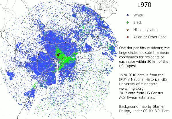
This slight westward movement is somewhat surprising, given the massive migration of black people (both from within the region and around the country) to southern and central Prince George’s County during the last 50 years, and the replacement of many black residents of the Mid-City with residents of other races during this time.
It indicates that there was also a significant increase in the black populations of the western suburbs that is less visible on the maps than the suburban population in Prince George’s County because these areas are more integrated than the southern Prince George’s neighborhoods, which are often 90% or more black.
The population centers for other races were all significantly to the northwest of that for black residents in 1970. The white population center in that year was in DC, just west of the Old Soldiers’ Home.
The Asian or other race, and Latinx population centers were located slightly to the south, just east of Columbia Heights. Over the last fifty years, the three non-black groups’ population centers all moved to the west in almost the exact same direction, and much faster than the black population center moved.
This western motion seems to have reached its peak at the 2010 Census, with the white population center located in the District just west of Rock Creek Park, the Hispanic/Latinx population center located on the Potomac near the quadruple-border of the District, Montgomery, Fairfax, and Arlington counties, and the Asian or other race population center located along the Potomac just downstream of the American Legion Bridge.
The movement of the white population center likely moved less to the west than the Hispanic/Latinx and Asian or other race population centers because of the shared Baltimore-Washington suburbs in Anne Arundel County that have remained much whiter than most of the region’s other suburbs.
Within the beltway in the 1970s, populations of color were centered mostly within DC
Source: Data from 1970 through 2010 Decennial Censuses from the IPUMS National Historical GIS project at the University of Minnesota; 2017 data from the US Census Bureau’s American Community Survey. 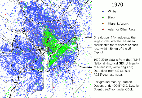
A view of the area inside the Beltway—where most residents were still concentrated in 1970—shows that in 1970, populations of color were nearly entirely located inside the borders of the District of Columbia. The only population of color visible on the 1970 map is African American. Other than a small African American neighborhood in Old Town Alexandria that dates back to an Antebellum free African-American community and another one in south Arlington, the only visible black population in 1970 outside of the District is in a small swath of Prince George’s County inside the Beltway and between US Route 50 and Central Avenue. Within the District, black residents dominated essentially the entire area east of 16th Street in 1970.
Over the course of the last fifty years, the black population in the District became less dense, particularly northwest of the Anacostia River, while Prince George’s County south of US Route 50 became nearly entirely black, and blacks become substantially more common in northern Prince George’s and eastern Montgomery Counties.
Other racial communities of color also developed over the course of the study period: in 1990, substantial Hispanic/Latinx populations became visible in Columbia Heights in the District and Langley Park in Maryland. It is notable that the Columbia Heights area transitioned from African American to Hispanic/Latinx, while the Langley Park area appears to have been entirely white before transitioning to Hispanic/Latinx.
Other Hispanic/Latinx populations develop over the course of the 1990s and 2000s, and although Hispanic/Latinx residents still appear to mostly be clustered in ethnic enclaves, these are found nearly everywhere in the suburbs except for Prince George’s County south of Route 50 and the rich, low-density areas along the Potomac River northwest of the District.
Identifiable Asian American enclaves start to appear in Fairfax County in the 1990 Census, and by the 2000 Census, they are found throughout Fairfax and Montgomery Counties and in parts of Arlington. Interestingly, a significant number of Asian American residents appear in downtown DC in 2000. The only other group to increase its presence in the District in the 2000s and 2010s is whites, who begin to expand into Capitol Hill starting with the 1990 Census and into the Mid-City in the 2000 and 2016 data.
About the data:
The analysis and maps in this article are based on data from decennial censuses accessed through the IPUMS National Historical Geographic Information System (NHGIS) project at the University of Minnesota. Although the U.S. Census Bureau’s online data portal only provides relatively recent data, NHGIS has digitized a large amount of older data from decennial censuses going back at least to the start of the 20th century. However, the race and ethnicity data at the census tract level that I used for these maps is only available starting with the 1970 Census.
Using the NHGIS data from the 1970 through 2010 Decennial Censuses, along with 2017 ACS five year data obtained directly from the Census Bureau’s online data portal, I mapped race by placing one randomly located dot per fifty residents in the land area of each census tract in the District of Columbia; Prince George’s, Montgomery, Charles, Calvert, Anne Arundel, and Howard Counties in Maryland; and Arlington County, the City of Alexandria, Fairfax County, the City of Falls Church, the City of Fairfax, the City of Manassas, the City of Manassas Park, Prince William County, and Loudon County in Virginia. For the 1970 and 1980 Censuses, when some of the outlying counties were not divided into census tracts, I used minor civil divisions in place of census tracts for those counties. I then cropped the resulting maps to a circle 50 kilometer in radius centered on the U.S. Capitol.
For the 1980 through 2017 data, I used the Census’s race-and-ethnicity data to classify residents as Hispanic/Latinx, non-Hispanic white, non-Hispanic black, or non-Hispanic Asian or some other race. The 1970 data does not break down non-Hispanic residents by race, so I assumed that all Hispanic residents were white and subtracted the Hispanic population from the white population while retaining the black and Asian or some other race population figures as reported. This decision was based on the fact that the majority of the Hispanic population in later years reported their race as white and, since the Hispanic population of the region was quite small in 1970, should not badly distort the 1970 data in any case.