How different parts of Montgomery County used to be divided and named

The 1865 Martenet Map of Montgomery County, showing the county’s election districts. by Simon J. Martenet, digitized by the Library of Congress.
In July, I wrote about how Prince George's County was subdivided into “hundreds” and later into “election districts” during the 18th and 19th centuries. By popular demand, I'm following up that post with a discussion of these same subdivisions in the history of Montgomery County.
Montgomery County was part of Prince George's and Frederick Counties
Maryland's colonial period lasted from 1632 until 1776, when it joined the other 13 colonies in rebelling against Great Britain. However, Montgomery County was not established until the state declared independence in 1776. The man it was named after, Major General Richard Montgomery, was an American officer in the Revolutionary war who had died the previous December in the Battle of Quebec.
The land that is now Montgomery County had virtually no European colonists when Prince George's County was established in 1696, and it — along with Frederick County, a part of Carroll County, and all of Western Maryland — was initially included in Prince George's County.
Like all counties in colonial Maryland, Prince George's County was divided up into “hundreds,” which were administrative divisions used by the county and colony for collecting taxes and appointing constables and other government officials, but were not self-governing.
The term “hundred” was imported from England, and similarly-named subdivisions were historically used in a number of European countries. While its etymology is unclear, it likely originally referred to an amount of land that could support a hundred families, or provide a hundred men at arms in wartime.
In colonial Maryland, there was a rough association between hundreds and population. New hundreds were established in settled areas as their populations increased, but being of a practical size for administration seems to have also been relevent.
Censuses in colonial Maryland were counts of “taxables” — namely all non-Native men, enslaved or free, over the age of 16 as well as enslaved women over the age of 16 — rather than total populations or numbers of households. However, from a low of about 100 taxables per hundred when the county was established, the number of taxables per hundred rose to about 300 by the 1730s, and remained at roughly that level until the Revolution.
When Prince George's County was established in 1696, its original six hundreds barely covered the land currently within the county's borders: most of the county's western and northern territory, including present-day Montgomery County, was left unorganized as a wilderness without European settlers.
A map of the hundreds in 1745 in the portion of Prince George's County that would later become Montgomery County. Image by the author.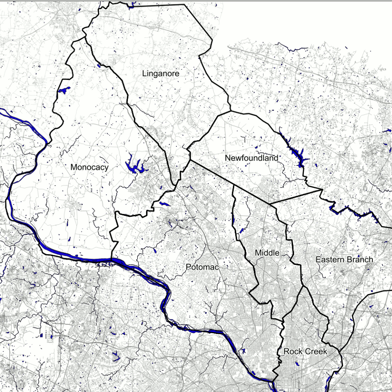
By the mid-1700s, though, hundreds had been established throughout Prince George's. The large size of the settled area was beginning to be unwieldy, so Frederick County was established in 1748 out of the land northwest of the current Montgomery-Prince George's boundary, including all of present-day Montgomery County.
The American Revolution and the Establishment of Montgomery County
Although Frederick County was sparsely populated when it was established in 1748, its population grew rapidly. By the time of the American Revolution, its large size was again causing administrative difficulties, as much of the population was extremely far from the county seat in Frederick.
A map of the hundreds of Montgomery County at its establishment in 1776. The exact boundaries between Upper and Lower Newfoundland Hundred and between Upper, Middle, and Lower Potomac Hundred are approximate. There may have been an additional hundred called Seneca Hundred in the vicinity of Gaithersburg. Image by the author.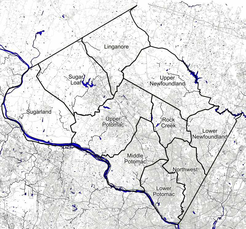
At a convention to draw up a new Maryland constitution in fall 1776, the delegates voted to divide the county in thirds, establishing Montgomery County with its current borders (minus the portion of Takoma Park transferred from Prince George's County in 1997 and plus the portion of the county now within the District of Columbia).
Although it redrew the boundaries of a number of counties (and necessitated the redrawing of the boundaries of hundreds that now crossed county lines), the constitutional convention maintained the basic administrative structure of counties subdivided into hundreds.
The newly-established Montgomery County was divided into 10 or 11 hundreds. Montgomery County: Two Centuries of Change, by Jane C. Sween, lists 11, but does not include a map, and “Seneca Hundred,” which Sween says contained present-day Gaithersburg seems questionable, as that was the previous name of what became Sugarland and Sugarloaf Hundreds, but did not originally contain Gaithersburg. I have chosen to show Gaithersburg as part of Upper Potomac Hundred on the above map.
Election districts in the 19th Century
In 1800, in addition to Maryland's cessation of parts of Prince George's and Montgomery Counties to form the District of Columbia, the hundreds that had existed for over a century were abolished and replaced with “election districts.” These seem to have been administrative divisions more akin to modern-day precincts, as elected offices were selected at-large for the county as a whole.
Like Prince George's County, Montgomery County was initially divided into five election districts: from northwest to southeast, Clarksburg, Cracklin, and Berry along the Patuxent and Medley and Rockville along the Potomac.
The original election districts of Montgomery County, from their establishment in 1800 until they were redrawn in 1878-1880. Image by the author.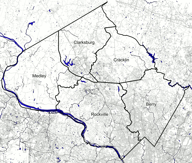
Unlike Prince George's County, which created a number of new districts during the Antebellum period, Montgomery County seems not to have changed its district boundaries until 1878, and the original five districts can be seen on Martenet and Bond's 1865 map of the county.
In 1878, several new districts were created, as can be seen in the Hopkins Atlas of Fifteen Miles Around Washington published in that year. A Bethesda district was created from the southeastern portion of the Rockville district, a Darnestown district was formed from portions of the Medley and Rockville districts, and a Mechanicsville district was formed from portions of Cracklin and Berry.
The election districts of Montgomery County from 1880-1890. Image by the author.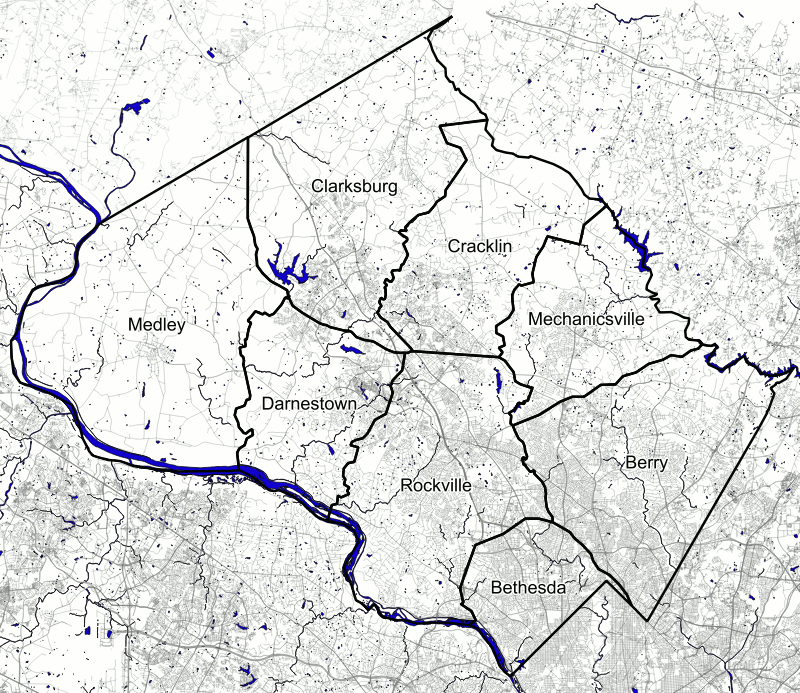
The newly established districts remained for about two decades without further changes. However, by 1890, the eight districts of 1878 had increased in number to 13: the same districts that, with minor boundry changes — and some changes to their names — exist to this day.
Ironically, these districts won't help settle the eternal debate over what counts as “Silver Spring,” since none of them bear that name. Instead, Downtown Silver Spring is in the Wheaton district, while some parts of Greater Silver Spring extend into the Colesville and Olney districts.
The present day
In the aftermath of the 1962 Supreme Court Baker v. Carr ruling that state legislative districts were required to be regularly reapportioned to have equal population, Maryland's election districts with their relatively stable boundaries became untenable. In 1972, the state switched to its current system of legislative districts, which often cross county lines and are redrawn after each Census.
However, the old “election districts” still remain, and their boundaries are updated from time to time by county governments. The main purpose for these boundaries is in the definition of actual legislative districts. Election precincts are also established within individual election districts.
The current election districts of Montgomery County, which have had approximately this form since 1890. Image by the author.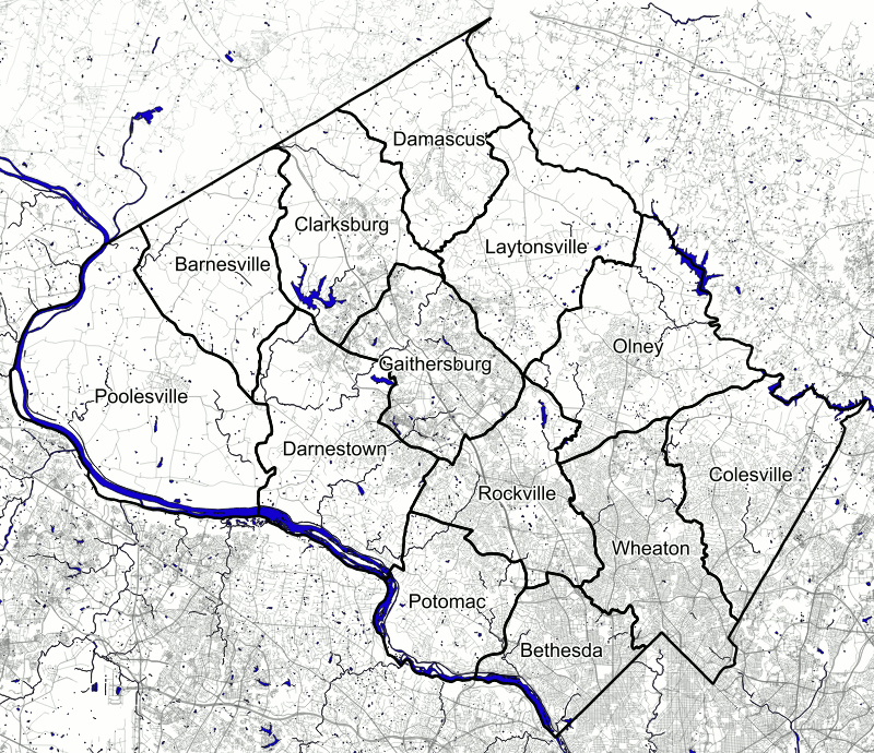
In addition to helping define districts used for General Assembly and local elections, Maryland's election districts are used by the Census as “minor civil divisions” for tabulating data. While every state is divided into counties or county-equivalents (Louisiana's parishes, Alaska's boroughs, and independent cities in Virginia, Maryland, Missouri, and Nevada), administrative divisions below the county level vary.
Although the Census does tabulate data by municipalities and Census-designated places, these can only be found in relatively-densely settled areas, and don't cover the entirety of counties in the same way that counties cover the entirety of states. However, counties in many northeastern and Midwestern states are divided into administrative districts that cover the entire state called “civil townships.” States with civil townships use them to tabulate Census data as minor civil divisions.
There are roughly 20 southern and western states where the Census draws its own county divisions because there are no usable state-drawn ones. Although election districts in Maryland have only vestigial functions today, they are still used to tabulate Census data.
