The map for Baltimore’s new bus system is positively radiant
The downtown portion of the new BaltimoreLink bus map. Click to see the entire thing. Image by Maryland Transit Administration.
Baltimore will soon be the latest American city to overhaul its bus network in an attempt to jumpstart ridership. The plan, known as “BaltimoreLink,” will go into effect on June 18. So far the best part is a really, really cool new map.
In August 2015, Houston completely overhauled its bus network overnight, replacing decades-old, antiquated routes with optimized ones that better serve employment centers, and more frequent service on the most heavily used lines. A year later, ridership grew by 6.8 percent, and other cities took notice. Anchorage, Jacksonville, and Columbus all followed suit, hoping to see the same success, and now Baltimore is next.
The core of the BaltimoreLink plan is a dozen color-coded, high-frequency routes known as CityLink lines. They'll run 24 hours a day along Baltimore's downtown grid and then radiate out of the city in every direction, complimented by less frequent local and express lines.
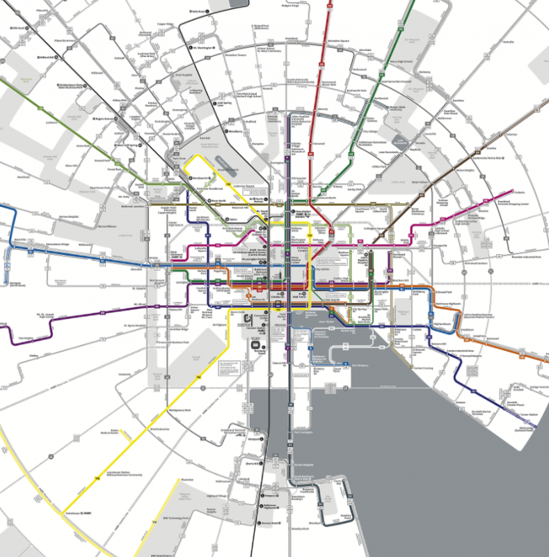
To show this, the Maryland Transit Authority and designer Marc Szarkowski have used what's called a diagrammatic radial style for the official BaltimoreLink system map. The result is quite striking.
The downtown portion of Baltimore's map. Image by Maryland Transit Administration.
A radial map is an interesting concept to which surprising number of transit networks can be adapted. Designer Max Roberts of Tube Map Central has applied this style to several cities, including the Washington Metro.
However, most transit networks aren’t structured in a way that makes this the most appropriate visualization, as creating a radial map can require sacrificing a bit too much geographic accuracy to maintain the structure. That's why you don’t often see radial maps used in an official capacity.
Image by Maryland Transit Administration.
But BaltimoreLink was actually designed with a radial structure, so this style does make good sense. Szarkowski’s map demonstrates this excellently by applying a hybrid style that keeps the layout coherent and understandable: a standard grid downtown and a radial style as the lines stretch out into the farther-out areas.
Like the Metrobus map redesign from four years ago, the BaltimoreLink map abstracts the lines to emphasize the most important information, as riders can refer to line-specific maps for more detailed information about specific routes.
Bus networks are inherently very complex and can feel pretty overwhelming; just look at the existing Baltimore bus network map. In this sense, BaltimoreLink already feels like a significant improvement. The diagrammatic style combined with the color-coding system for the CityLink lines give the design and the system a Metro-like feel, which can go a long way to making riding the bus feel less intimidating and boost ridership.
It will remain to be seen if BaltimoreLink as a whole will be as successful as bus overhauls in other cities, and the plan is no substitute for the canceled Red Line subway. But as core element of the effort, this map is definitely a successful step forward.