I can take the bus from my neighborhood to just about anywhere in DC
I’d love for more of my neighbors to consider riding the bus, so I made a spider map to show just how far we can go on all the routes that run through where we live. It turns out that on the bus, we can go from LeDroit Park to nearly every other part of DC.
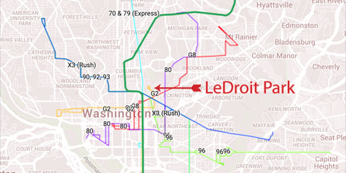
Click for larger interactive version.
Washington enjoys an extensive bus network, yet buses remain the most underappreciated mode of transit. Buses may be slower than Metrorail, but their coverage of DC is unbeatable.
One reason fewer Washingtonians ride buses than trains is that it’s hard to understand the complex bus system, which has criss-crossing routes that all look the same and have hard-to-remember names.
Better marketing, like Peter Dunn’s H Street spider map, can help demystify the bus and get more riders onto it.
The map I made shows people in LeDroit Park how they’d ride to Adams Morgan, Woodley Park, the National Cathedral, and Tenleytown to the northwest, a way to get to Logan Circle, Dupont Circle, and Georgetown without having to worry about parking, and how to get to and from H Street’s night life without having impaired driving even being a concern.
For those who frequently use Metro, knowing the area’s available bus routes brings the comfort of a backup plan for unexpected service disruptions on the Green Line. When the Metro tunnel fire on January 12 shut service to our main Metro station, a lot of my neighbors could have taken a number of buses home from downtown or from connecting Metro lines, but they didn’t know it.