What WMATA is really suggesting
Metrorail is nearing its capacity, with heavy load in many key points throughout the system. At last week’s WMATA board meeting, staff presented recommendations for capital improvements to increase capacity at the bottlenecks.
Press outlets covered the topic, but often with confusion on details. WTOP covered the Georgetown/M Street proposal but wrote that the new line would run “through the top of the District,” adding, “It’s not known if the new line would be a tunnel or an aerial structure.” The ridiculousness of an elevated trackway up Wisconsin Avenue led to this incredulous story on DCist, generating more meta-discussion.
What is WMATA really proposing? Based on this presentation, here’s a handy map of what Metro could look like in 2030 if WMATA gets its way:
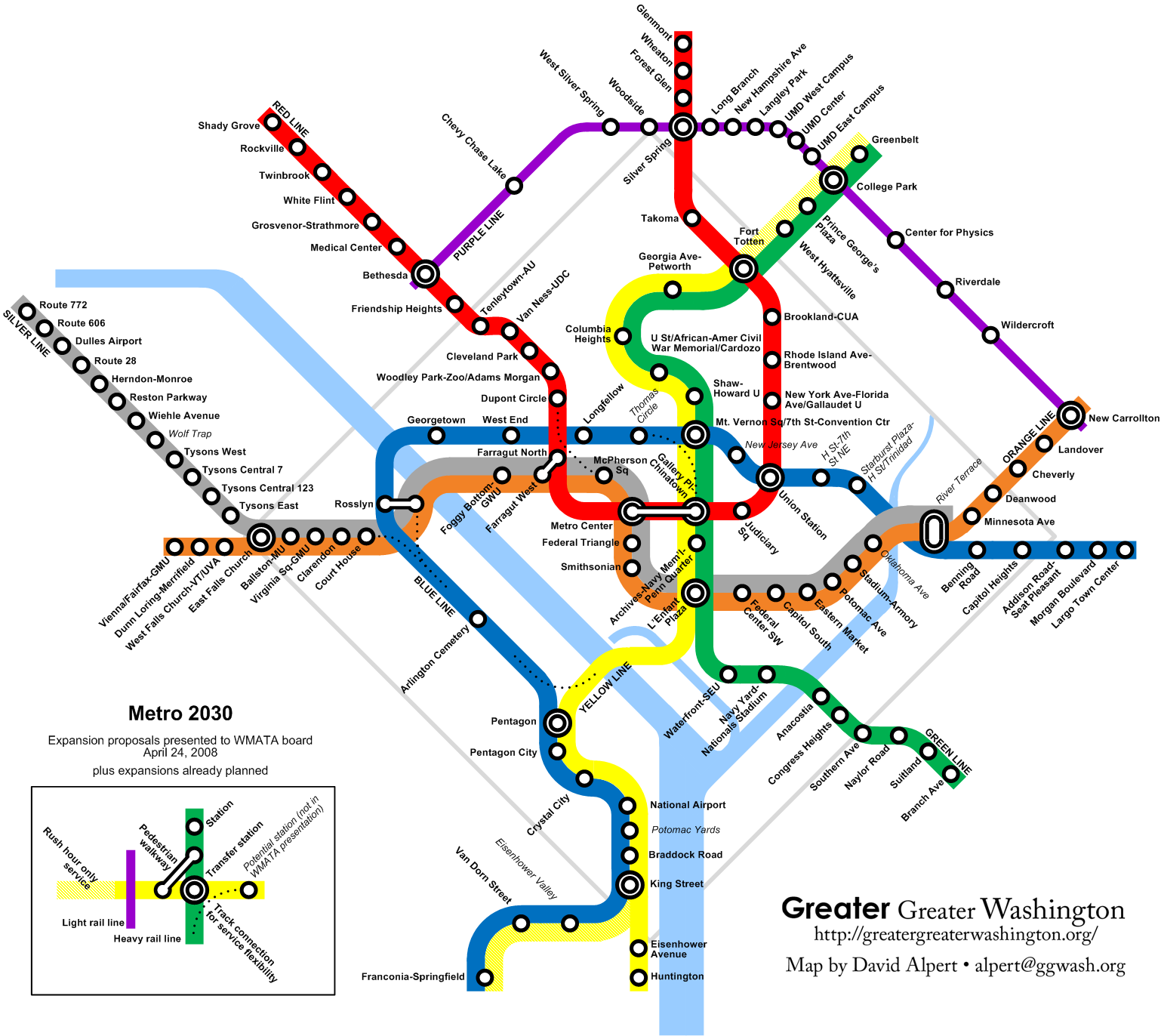
Below, a detailed list of the improvements in the WMATA presentation and this map.
Silver and Purple Lines built as proposed by Virginia and Maryland.
Separate Blue Line. This new line through downtown, originally proposed in 2001, would split off from the Orange Line at Rosslyn, cross the Potomac in a new tunnel to Georgetown, then run east along M Street to Mount Vernon Square and then Union Station.
The WMATA presentation’s map shows the line heading down Massachusetts Ave from Thomas Circle to Union Station, but my map shows it continuing along M Street to facilitate a better transfer at Mount Vernon Square (since the station is actually on M rather than at the square itself).
Reports are vague on what the line would do east of Union Station; the old Post map showed it going to Stadium-Armory, but it would make more sense for it to run straight down H Street and cross the river with the Orange Line, letting riders connect between the two at a new infill station between River Terrace and the soon-to-be-closed Pepco plant.
Update: I’ve modified the map to show the Blue Line running to a separate Rosslyn station one block west of the current one, connected by an underground walkway, to better match WMATA’s best thinking on the physical reality. The previous map is here.
The “Blue Line split”. Not to be confused with the M Street subway, this is a short-term proposal by WMATA to send some trains from Franconia-Springfield up the Yellow Line and then to Greenbelt. WMATA’s map is horribly confusing; as I’ve argued before, it makes much more sense to simply call those trains Yellow Line trains.
Pedestrian walkways. Farragut North and Farragut West were originally supposed to be one station with a transfer, according to The Great Society Subway, but the National Park Service blocked that plan. A walkway would allow transfers from Red to Orange without riding an extra three stops down to Metro Center and back.
Likewise, Metro Center and Gallery Place are actually very close together, but many people ride the Red Line one stop when going to or from one of those stations. And people transferring from Yellow/Green to Orange/Blue have to use the Red Line or ride five extra stops down to L’Enfant Plaza and back.
Track connections. The presentation recommends adding connectors between lines so WMATA can route trains around problems or add extra service in high-traffic spots. They’re proposing connectors between Court House and the Blue Line toward Arlington Cemetery; between the Blue Line on the other side of Arlington Cemetery and the Yellow Line bridge over the Potomac; between the Red Line north of Farragut and the Orange Line at McPherson; and between the potential M Street line around Thomas Circle and the Yellow/Green at Gallery Place.
The one useful connection missing from the WMATA presentation is one between the Yellow Line bridge and Waterfront. Being able to run trains from Virginia directly to the new ballpark would give Virginians an easy Metro route to baseball games and relieve a lot of congestion at L’Enfant Plaza. Coupled with the Orange-Blue and Blue-Yellow connectors also proposed, they could even run Orange or Silver Line trains from Fairfax or Leesburg/Dulles/Tysons all the way around to the ballpark without having to pass through downtown DC.
Infill stations. Alexandria has proposed new infill stations at Potomac Yards and Eisenhower Valley. An Oklahoma Avenue station between Stadium-Armory and the Anacostia River has also been kicking around for years (in fact, it was planned for the original Metro system and then canceled). This stations aren’t mentioned in the WMATA presentation.