Posts by Adam Froehlig — Contributor
-

How much land is in each quadrant of the District?
How much of each of DC’s quadrants is land? Water? Parks? Military bases? The quadrants aren’t all equal. Far from it. I created this map using shapefiles from DC OCTO to illustrate how the areas differ. Keep reading…
-

Ask GGW: The W&OD Trail’s sharp turn
A reader recently wondered why the Washington and Old Dominion Trail turns sharply at Idylwood Park next to I-66 in Falls Church instead of tunneling under the interstate and Metro. “Was this by design when they were constructing I-66?” asked Mark Scheufler. Keep reading…
-

How big of a “moat” would the FBI need if it stayed downtown?
The FBI and the General Services Administration (GSA) are searching for a site to house a new consolidated FBI headquarters. Though no sites in DC remain in consideration, there are a few who wonder why they don’t just reuse the existing Hoover Building site on Pennsylvania Avenue. Keep reading…
-

14th Street bridge area needs a good bicycle connection
Bicycling to and from the 14th Street bridge on the DC side is not a pleasant experience. Cyclists must choose between harrowing high-speed roadways, too-narrow sidewalks, or long detours. The 14th Street Bridge EIS doesn’t address this connection, but it needs to, immediately. The Mount Vernon Trail, along the Potomac River in Virginia, has a few faults but it provides… Keep reading…
-

I-695 label returns to DC, but it never really left
DDOT opened the inbound 11th Street Bridge this past weekend. Drivers are already confused, not from the change in the lane split from I-295, but in the route number chosen for the bridge: I-695. Why did DDOT sign the bridge as I-695? This is a question that been pondered by blogs, the news media, and numerous tweets. The confusion got so bad that DDOT wrote their… Keep reading…
-
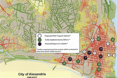
Alexandria joins Capital Bikeshare
After a process spanning several months, the Alexandria City Council voted unanimously last night to join the Capital Bikeshare system. The first stations are expected to come online between spring and summer 2012. Keep reading…
-

Regional map data is expensive
Detailed map data offers tremendous potential to expand our understanding of the world in which we live. Unfortunately, most localities in the immediate area charge for this data, which should be publicly available to everyone. Past posts on Greater Greater Washington have featured user-created maps based on GIS (Geographic Information Systems) data from DC and Alexandria. DC’s… Keep reading…
-
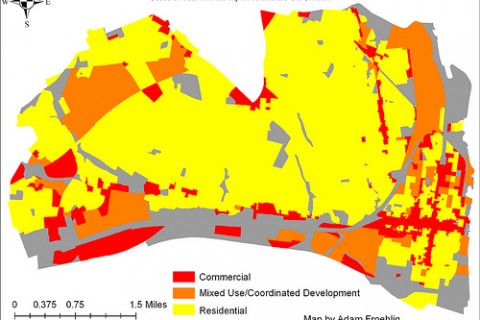
Alexandria gets the mapping magic
Dan Malouff created a series of thematic maps of DC using GIS data available from the DC Office of the Chief Technology Officer (OCTO). He posted maps of topography, building footprint, and basic land use. Inspired by that, I created similar maps for Alexandria using data from the city’s GIS Division. Basic land use This map simplifies the city’s zoning… Keep reading…
-

How much land is in each quadrant?
How much of each of DC’s quadrants is land? Water? Parks? Military bases? The quadrants aren’t all equal. Far from it. Keep reading…