Ask GGW: The W&OD Trail’s sharp turn
A reader recently wondered why the Washington and Old Dominion Trail turns sharply at Idylwood Park next to I-66 in Falls Church instead of tunneling under the interstate and Metro. “Was this by design when they were constructing I-66?” asked Mark Scheufler.
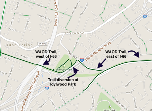
The W&OD Trail where it meets I-66. Base image from Google Maps.
After the W&OD railroad stopped running in 1968, VDOT bought some of the right-of-way to use for the alignment of I-66. The rest of the W&OD right-of-way was sold to VEPCO (which later became Dominion).
In 1977, the Northern Virginia Regional Parks Authority came to an agreement with VEPCO to purchase segments of the W&OD right-of-way as funding became available, which in turn enabled NVRPA to construct the trail. Incidentally, this was also the same year that the “Coleman Agreement” allowed for the construction of I-66 inside the Beltway.
A W&OD extension came first, as the trail was completed between Falls Church and Vienna in 1979, including the section across I-66.
It's unclear why the W&OD was routed along the edge of Idylwood Park and across Virginia Lane instead of cutting straight through. One possibility is that NVRPA and VEPCO couldn’t come to an agreement on the right-of-way between I-66 and Virginia Lane. Another possibility is that VDOT objected to a trail tunnel and thus forced NVRPA to use the park and Virginia Lane.
It’s more likely, though, that the decision was a cost-saving measure. At the time, NVRPA was trying to locate funding to purchase the W&OD right-of-way and build trail segments. Using the already-planned Virginia Lane overpass over I-66 would have allowed VDOT and NVRPA to save money over the cost of a separate trail tunnel.
The trail diversion happens at a pretty sharp angle and it involves a hill climb. But the existing path along the edge of Idylwood Park and Virginia Lane is only about 400 feet longer than a routing that would’ve stayed in the rail right-of-way. For a bicyclist averaging 10 mph, that’s less than 30 seconds.