Part II: A better plan for joining up the MBT through Takoma and Takoma Park

Bicyclist along Metropolitan Branch Trail (MBT) at New York Avenue, NE by Elvert Barnes licensed under Creative Commons.
In part one of this series, I reviewed the Metropolitan Branch Trail (MBT)’s history, current status, and the District Department of Transportation (DDOT)’s designs of the MBT from Fort Totten to Takoma Park, Maryland. I argued that DDOT’s “initial” design to route the MBT around the Takoma Metro station is unsafe, expensive, and will take awhile to build. In part two, I offer an alternative route for the MBT through Takoma and around the Metro station.
I believe this alternative solves many of the problems with DDOT’s design and also provides better connections for current Takoma residents and its growing residential and business community. Doubtless most people reading this want to see the MBT finished, but the details matter for such an important piece of trail infrastructure.
Takoma connections
The neighborhoods of Takoma, DC, and Takoma Park, Md., may be legally separated, but the history between these two communities is united. There is no physical border here and residents on each side have friends, relatives, and regularly patronize the businesses. But for an entry sign or the historical DC boundary stone, you’d never know that you’re leaving DC and entering Maryland or vice versa. Our local business association supports both sides of the border.
Map of business districts in Takoma, DC, and Takoma Park, Md. Image from Main Street Takoma and used with permission. 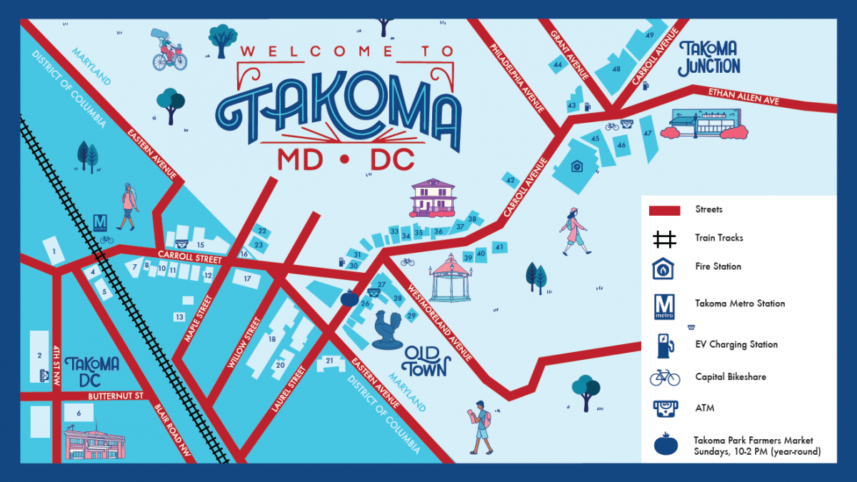
DDOT’s design plans to wedge the MBT west of the railroad tracks and the backyards of a condo building completely ignores the history of this area, and it fails to connect the MBT to both the many future DC residents and businesses that will be located east of the Takoma metro station and the Takoma Park residents just across the border.
A “better” MBT
DDOT’s design
DDOT’s design for the MBT through Takoma. Blue line is DDOT’s “final” design from Ft. Totten. Red lines are in the “initial” design phase. Image from Google Maps. 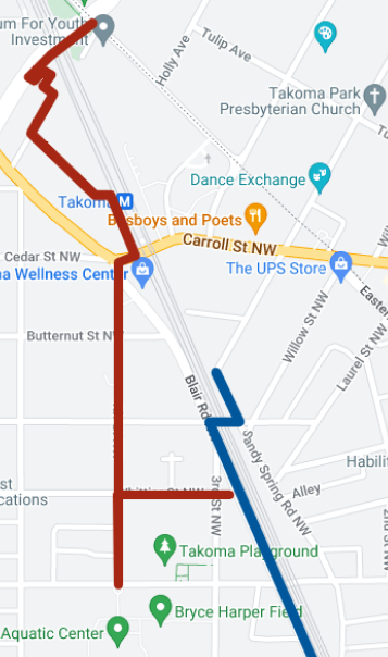
A “better” MBT
Alternate route for the MBT through Takoma. Blue line is DDOT’s “final” design from Ft. Totten. Red line is DDOT’s route I retain. Green lines are my changes. Image from Google Maps. 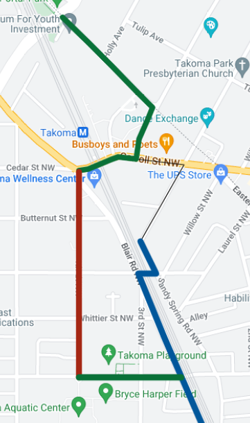
If policymakers’ goals are to provide a safe, low-stress trail that connects to homes, work, and play in Takoma, then I believe that this proposal is better than DDOT’s design. Around the Takoma Metro station, I recommend that DDOT change to an eastern alignment using Cedar Street and Eastern Avenue. My design retains DDOT’s western alignment for the MBT on 4th Street, but it changes the connection to Blair Road using Van Buren Street. This design also makes it easier to add a future eastern spur to access more Takoma destinations.
The eastern alignment around Takoma Metro station
An eastern routing around the station would align the MBT directly with the current MBT on Eastern Avenue. MBT users would cross Piney Branch Road and then continue up or down Eastern Avenue on a new protected MBT that could be adjacent to or replace the southern sidewalk on Eastern Avenue.
View of the MBT on Eastern Avenue crossing Piney Branch Road. Image from author. 
This stretch of Eastern Avenue from Piney Branch Road to Cedar Street is narrow for buses to access the Takoma Metro station, and the sidewalks are tight and full of obstacles. Yet, DDOT’s own records show they have 38 feet of right-of-way. With that much space DDOT could build a protected MBT adjacent to or on the south sidewalk and retain two wider travel lanes for buses by removing street parking on Eastern Avenue.
View of Eastern Avenue with a parked car in the distance. Image from author. 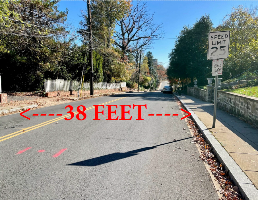
Residents on this stretch of Eastern Avenue have access to cheap street parking, but removing parking here is mitigated by three facts: (1) all the buildings provide off-street parking, (2) there is other street parking just across Piney Branch Road; and (3) all the detached houses on the other side of Eastern Avenue (in Maryland) have dedicated driveways.
DC policymakers updated their commitment to Vision Zero to say they are working aggressively to make “difficult decisions on trade-offs that always prioritize safety for our most vulnerable road users and populations …. The District takes this approach because everyone, including our children, seniors, neighbors, friends, and family members, deserves safe streets.” This stretch of Eastern Avenue is Exhibit A for such a trade-off.
Further down Eastern Avenue at the Metro parking lot the sidewalk is much wider to support a protected MBT to and around the intersection of Eastern Avenue and Cedar Street and then along Cedar Street until the “T” intersection. As shown below, this entire area is part of the Takoma Metro station which is getting redeveloped; and Metro’s business partner already envisions building a multiuse trail along both Eastern Avenue and Cedar Street.
Schematic design of Takoma metro station showing shared-use trail. Image from EYA. 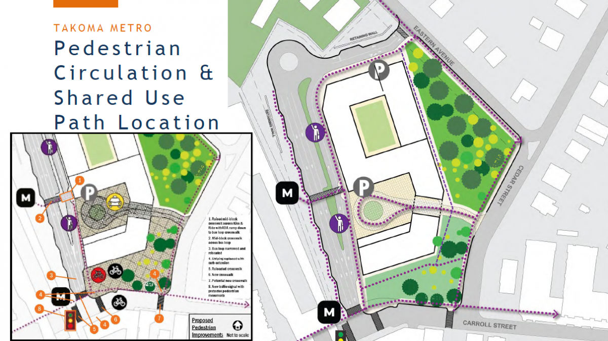
At the “T” intersection there is a traffic signal for a safe crossing to route the MBT on the southside of Carroll Street, which removes a huge conflict zone between MBT users and people going to/from the Takoma Metro station. Routing the MBT on the southside would require removing a handful of parking spaces, but as shown below there is plenty of other parking at and around the station.
Map showing locations of parking in orange near the Takoma Metro station. This design would remove street parking inside of the red oval and get replaced by the MBT. Image from Google maps and modified by author. 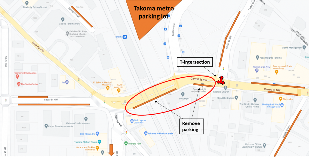
I scoured DDOT’s website to see if they studied using Eastern Avenue instead of their design and I could not find any such comparison, so I asked DDOT officials if they considered using Eastern Avenue and they responded in the negative. I believe that using an eastern route around the Takoma Metro station is superior by every metric except that it removes a bit more of street parking. Below is a table that I compiled to do an objective comparison between DDOT’s proposed routing and my alternate proposal.
Metric
DDOT design
Better MBT design
Segment travel distance
0.363 miles
0.391 miles
Fully protected MBT
No
Yes
Dangerous incline/decline
Yes
No
Need to acquire land
Yes
No
Need to excavate by metro
Yes
No
Cost to implement
$3 million plus cost of land
Unknown
Time to implement
Unknown
Unknown
Parking impact
Loss of 1-5 spaces
Loss of 5-10 spaces
Takoma connections*
2
6 now, but 9 in future**
* “Connection” means the MBT passes a place of business or public amenity.
** There are at least 3 new businesses coming to the east side of the Takoma metro station.
The intersection of Blair Road with Cedar and 4th Streets
DDOT’s plans for the MBT to cross Cedar Street is located in a high-conflict intersection for vehicles, pedestrians, and cyclists. My alternate design routes the MBT on the southside of the road instead of forcing users to cross this dangerous intersection. MBT users would cross Cedar Street further east where it’s less busy and much safer.
Instead of allocating all 48 feet of roadway for vehicles, DDOT could use 25% of the roadway for the MBT and then combine the right-turn and straight travel lanes going west at the intersection. By combining these travel lanes DDOT can still retain a left turn lane. Below are two drawings showing DDOT’s design and my design, along with a table comparing the differences.
DDOT’s design for the MBT to cross Cedar Street onto the north sidewalk of Cedar Street. Image from DDOT modified by author. 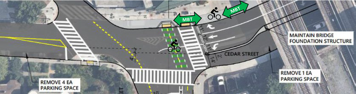
My proposal for the MBT to turn onto Cedar Street and proceed under the railroad tracks. Image from DDOT and modified by author. 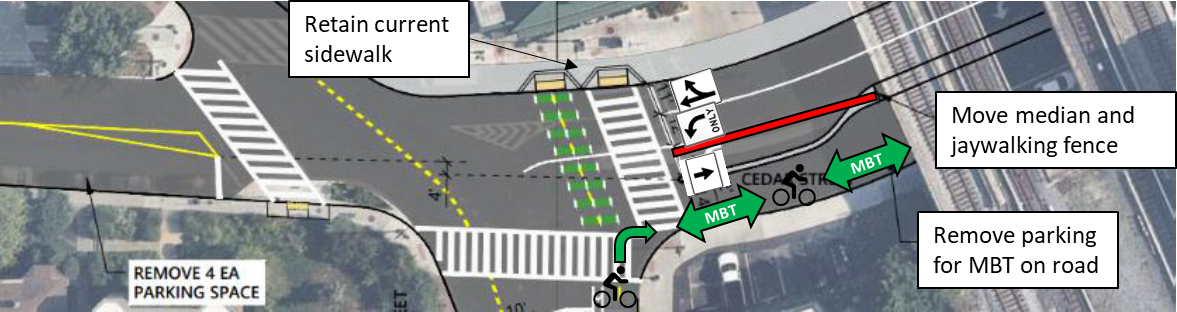
Cedar Street space
DDOT design
Better MBT design
Westbound right turn
11 feet
12 feet
Westbound straight
12 feet
Westbound left turn
11 feet
12 feet
Eastbound straight
14 feet
12 feet
Protected MBT space
0 feet
12 feet
Totals
48 feet
48 feet
Connecting 4th Street to Blair Road
As mentioned in part one, DDOT originally proposed connecting the MBT from 4th Street to Blair Road via Van Buren Street, but they changed their mind and now propose using the sidewalk on Whittier Street and removing 18 trees. This is nonsense as MBT users seeking to continue on will need to cross Blair Road without a traffic signal. Moreover, Van Buren Street cuts through the heart of Takoma’s recreational amenities, which would encourage more people to walk, run, and bike to access them.
Map showing DDOT’s previous routing (Green Line) and current routing (Yellow Line) for the MBT connecting 4th Street to Blair Road (Blue Line). Image from Google Maps. 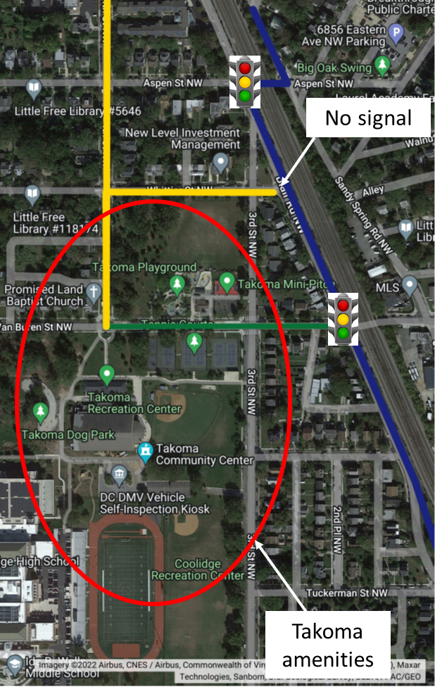
We can do better
In writing this blog series I found that Advisory Neighborhood Commission 4B and the Washington Area Bicycling Association support DDOT’s proposed design for the MBT in Takoma. When I asked WABA if they consider the design to be safe, they agreed that the steep slope by the railroad tracks isn’t ideal, but they do not find the design to be unsafe. Late in 2022, I contacted the designated ANC4B commissioners to ask a few questions about DDOT’s design, but nobody was willing to discuss the matter.
I believe there is a better MBT route that is safer, cheaper, and easier to build that is better for all MBT users and residents of Takoma. If you agree, then please contact your elected officials and ask for changes.