Plan to extend the MBT to Maryland has safety flaws

HOXXOH (Miami) DC Walls 2021 Mural along Metropolitan Branch Trail (MBT) at 227 Harry Thomas Way, NE by Elvert Barnes licensed under Creative Commons.
Over five years ago I wrote about the Metropolitan Branch Trail coming to Takoma, but there is yet to be a shovel in the ground. While Takomans are eager for the connection, many of us are glad that DDOT hasn’t started construction because we believe its design for the area is flawed.
The MBT is a “rail-trail” that used to host train service connecting Washington with the main line of the defunct Baltimore and Ohio Railroad. Seven miles of the trail are in DC and one mile is in Maryland, but when complete, it will connect to the Capital Crescent Trail that is being finished as part of the Purple Line train.
The Capital Trail Network inside of Washington, DC. Image from the Capital Trails Coalition 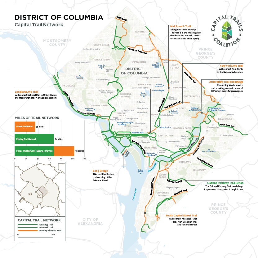
Currently, MBT users can connect with neighborhoods on an almost fully-separated MBT between Union Station and Fort Totten. DDOT left a gap in Brookland, but it appears that will soon be fixed. North of Takoma, the MBT is fully separated from Piney Branch Road in DC through Takoma Park, Maryland. After Takoma Park, Montgomery County will build the final MBT segment connecting to trails at the Silver Spring transit center.
MBT map from Brookland to Takoma Park, MD. Image from DDOT. 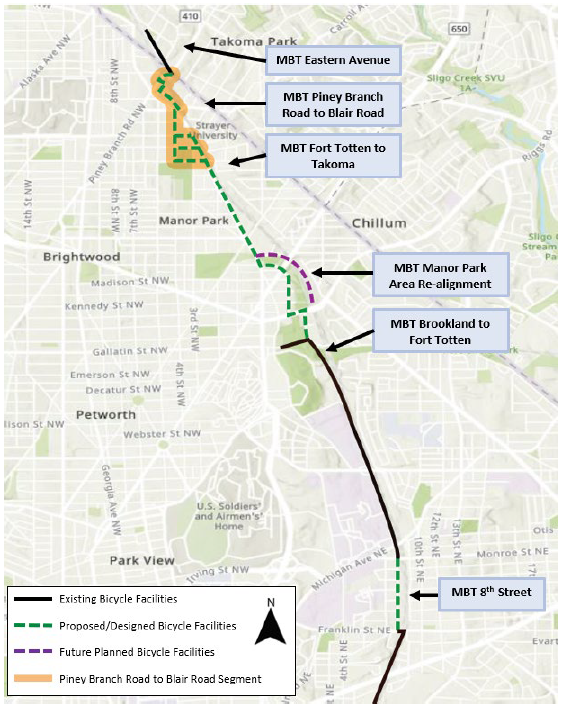
Residents support DDOT’s work to finish building the MBT, an important trail that has taken more than 20 years to build out. My goal is to point out some large issues with its designs from Fort Totten to Aspen Street to Takoma Park, so they can be addressed while there is still opportunity.
Problems with Fort Totten Metro station to Aspen Street NW
DDOT’s final design of the MBT on the Fort Totten Metro station to Aspen Street NW stretch hasn’t changed much since it was first planned. Here are my safety concerns about this stretch.
In Manor Park, DDOT is forcing MBT users on the road without any protection via sharrows. Once the MBT transitions to the sidewalk of Blair Road, it crosses 19 business driveway entrances where users must be on high alert for vehicles coming in and out.
Map of DDOT’s MBT design on the sidewalk of Blair Road showing 3 of 19 driveway entrances. Image from DDOT. 
Rendering showing 1 of 19 conflict points for MBT users. Image from DDOT. 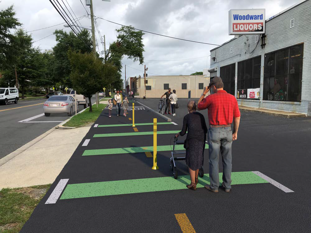
At Underwood Street, DDOT moves the MBT from the sidewalk onto Blair Road where it plans to build a protective wall between vehicles and MBT users. It’s an audacious plan to put northbound Blair Road on a road diet, reducing it from two lanes to one.
Design of the MBT and the protective barrier on Blair Road. Image from DDOT. 
I’m supportive of DDOT’s lane reduction plan for Blair Road, as it should curb vehicle speeds and aggressive driving. Changing driving behavior through better design is smart, but it also needs to be paired with enforcement, and sadly, DC has failed to enforce vehicle violations.
One concern about DDOT’s road diet design, however, is that it removes a left-turn lane for vehicles northbound on Blair Road at Van Buren/Aspen Streets. Children who live east of Blair Road walk and bike through these intersections under the railroad tracks to and from nearby schools and recreational amenities. DDOT should consider that aggressive drivers may swerve around vehicles turning left, which risks hitting MBT users.
Picture of Blair Road and Aspen Street intersection. Image from Google Maps. 
DDOT’s plans have the MBT turn under the railroad tracks at Aspen Street and cross with a spur onto Sandy Spring Road, then continue to Maple Street, where it ends abruptly on a narrow road without protection. DDOT said it plans to extend the MBT on Maple Street at some future undetermined date.
MBT design at intersection of Blair Road and Aspen Street. Image from DDOT. 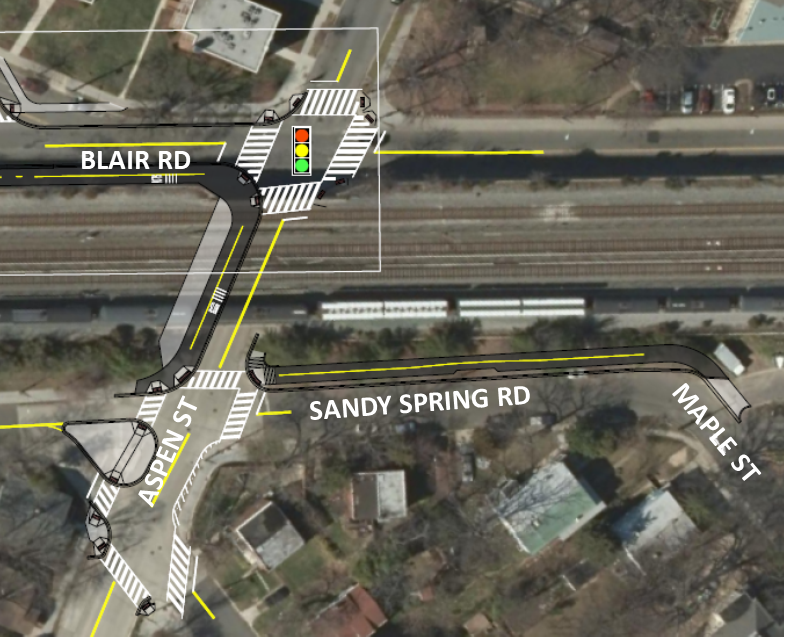
4 key issues with DDOT’s design around Takoma Metro station
DDOT has long wrestled with the decision of whether to route the MBT west or east of the Takoma Metro station. DDOT chose west, but its design is flawed in four ways: it’s unsafe, it’s expensive, it’s disconnected, and it will take awhile to build.
DDOT’s design for the MBT in Takoma. Blue line is the “final” routing from Fort Totten. Red lines are the “initial” routing through Takoma. Map from Google Maps modified by author. 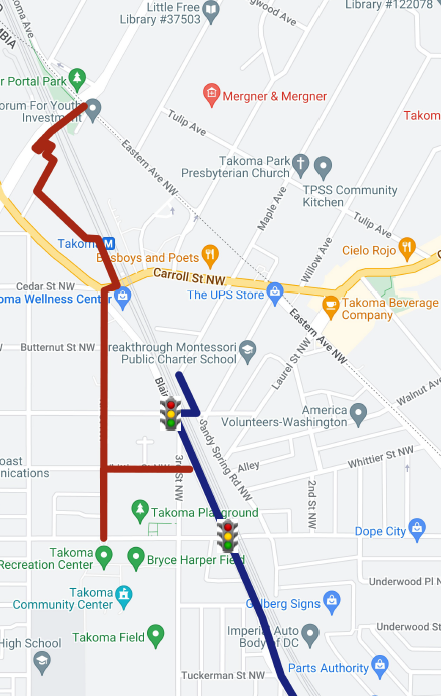
My review of DDOT’s design starts from the north, because that’s where it’s most worrisome. The MBT north of the Takoma Metro station is separated but adjacent to Eastern Avenue. DDOT’s design turns the MBT onto Piney Branch Road and forces MBT users to navigate a steep and curvy trail that intersects with stairs.
DDOT’s design for the MBT on Piney Branch Road to Eastern Avenue. Image from DDOT. 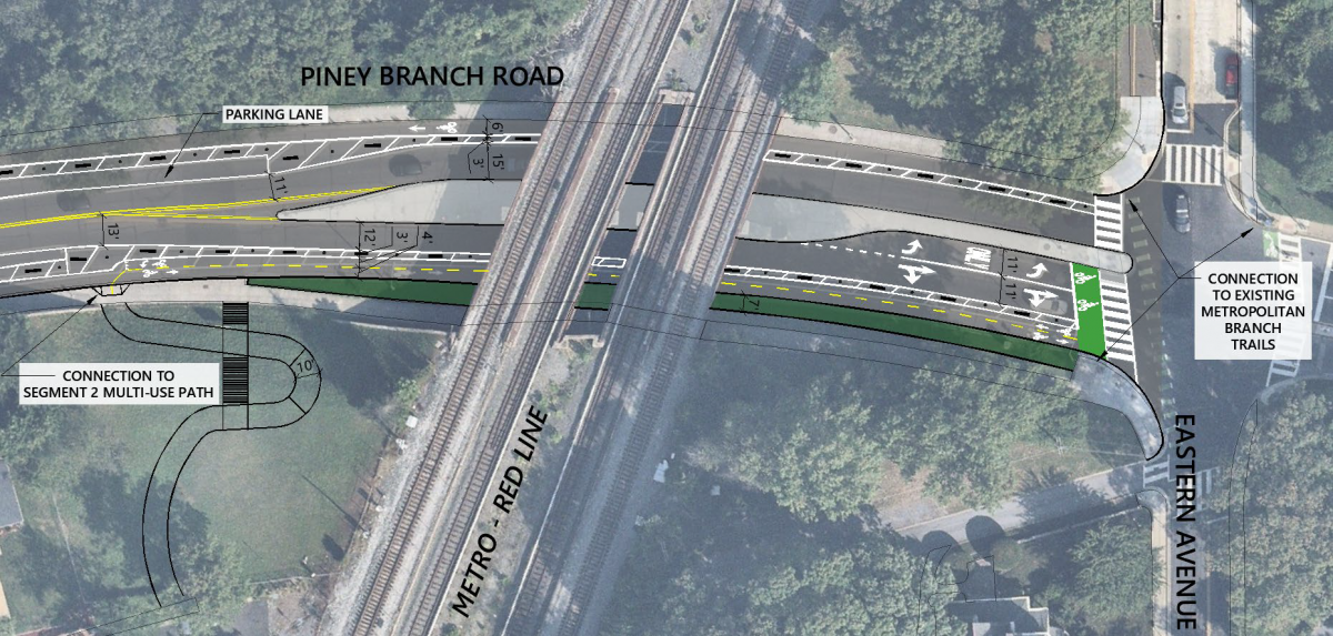
Design for MBT on Metro’s land between Piney Branch Road and Chestnut Street. Image from DDOT. 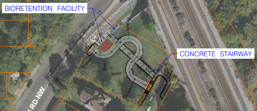
Existing conditions at Metro’s land between Piney Branch Road and Chestnut Street. Image from DDOT. 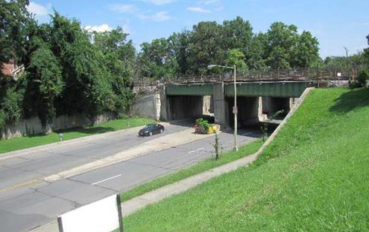
Then, MBT users will meander on residential streets before reconnecting to a trail behind the backyard of a condo building, until it dumps them onto the sidewalk where lots of people walk to and from the entrance of the station.
Map of DDOT’s plan to route the MBT on Chestnut Street. Image from DDOT. 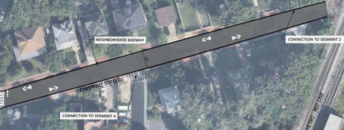
Map of DDOT’s plan to route the MBT on Spring Place with a Woonerf. Image from DDOT. This is a dead-end road, but it’s the only way for vehicles to access the parking garage for apartments at the Gables Takoma Park. 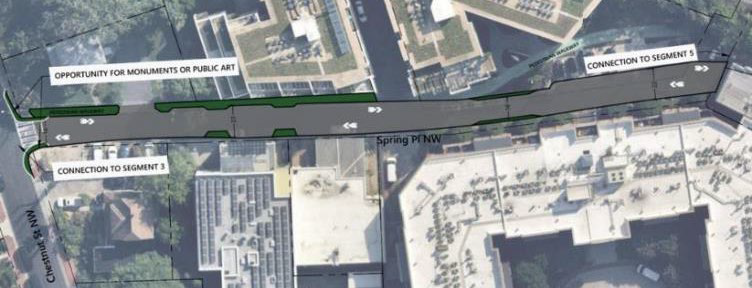
Map and design of DDOT’s plan to build the MBT between 343 Cedar Street and the Takoma metro station. Image from DDOT. 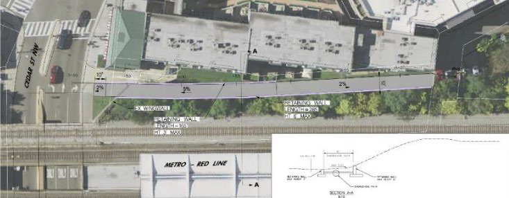
Area where DDOT plans to excavate the structural wall of the Takoma Metro station next to the parking garage exit of 343 Cedar Street. Image by author. 
The agency is proposing an 8-foot trail on Piney Branch Road and a 10-foot trail on the hill, both of which are narrower than recommended and provide little room for error. Cyclists must navigate a curvy path that intersects with two staircases while managing a 15% grade change.
DDOT officials told me that their design limits the grade to no more than 5% at a given point to comply with ADA guidelines. Nonetheless, going uphill/south, many cyclists will need to dismount with cyclists whizzing by going downhill. Going downhill/north, a 5% grade is fast for kids or novice riders who might hit someone else or lose control and end up on Piney Branch Road. Any parent who has ever rode a bike with a child should be terrified by this design.
Plus, this plan requires DDOT to acquire the vacant land from Metro; a former DDOT employee informed me the land was for sale in 2018 for $700,000. Let’s not forget the cost and time required to excavate around the Takoma Metro station. DDOT confirmed that excavation next to the railroad tracks must be coordinated with Metro and CSX Corporation, which likely means nothing will be built soon.
Adjacent to the Takoma Metro station, DDOT is planning to run the trail through the busy intersection of Blair Road with Cedar and 4th Streets, which is surrounded by multifamily buildings with many more slated to be built.
At a time when DC is going backwards on its Vision Zero goals, why is the agency proposing to put bicyclists on a hectic 48-foot-wide road with four travel lanes without protection? DDOT’s design creates conflicts for everyone: people out shopping, people walking to and from the station, cyclists, and vehicles exiting a parking garage.
DDOT’s design for the MBT to cross Cedar Street onto the north sidewalk of Cedar Street. Image from DDOT modified by author. 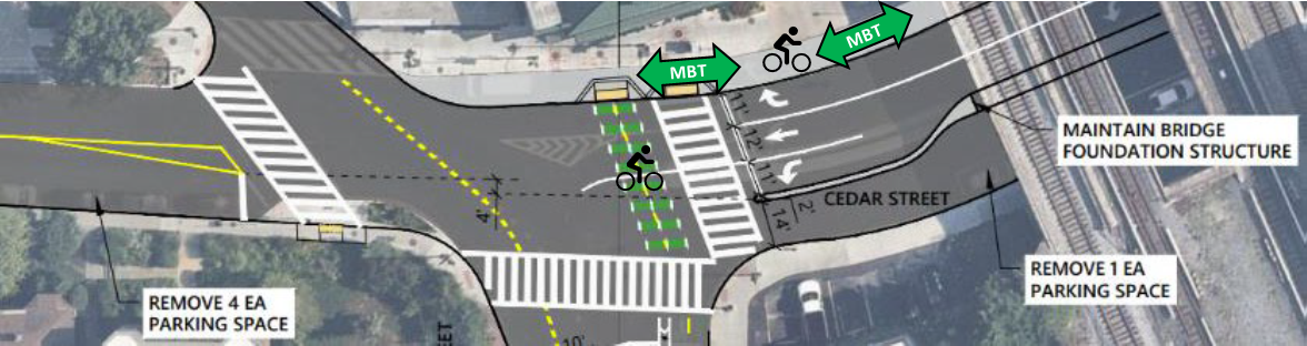
View of north sidewalk on Cedar Street where DDOT wants to route the MBT on the sidewalk. Image from author. 
Fantastic design on 4th Street, from Cedar Street to Van Buren Street
This long segment of the MBT through Takoma is the best part of DDOT’s plan. The design here is separated and routes MBT users directly past some of Takoma’s most-beloved businesses and amenities. Kudos to DDOT for this segment!
Map of proposed MBT on 4th Street from Cedar Street to Butternut Street. Image from DDOT. 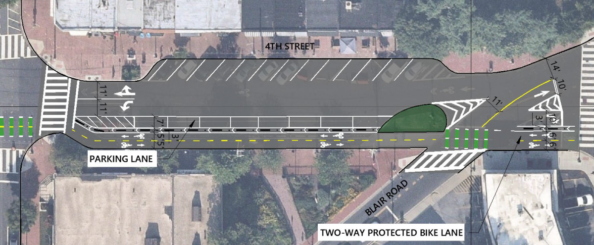
Map of proposed MBT on 4th Street from Butternut Street to Aspen Street. Image from DDOT. 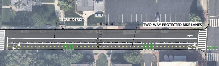
Map of proposed MBT on 4th Street from Aspen Street to Whittier Street. Image from DDOT. 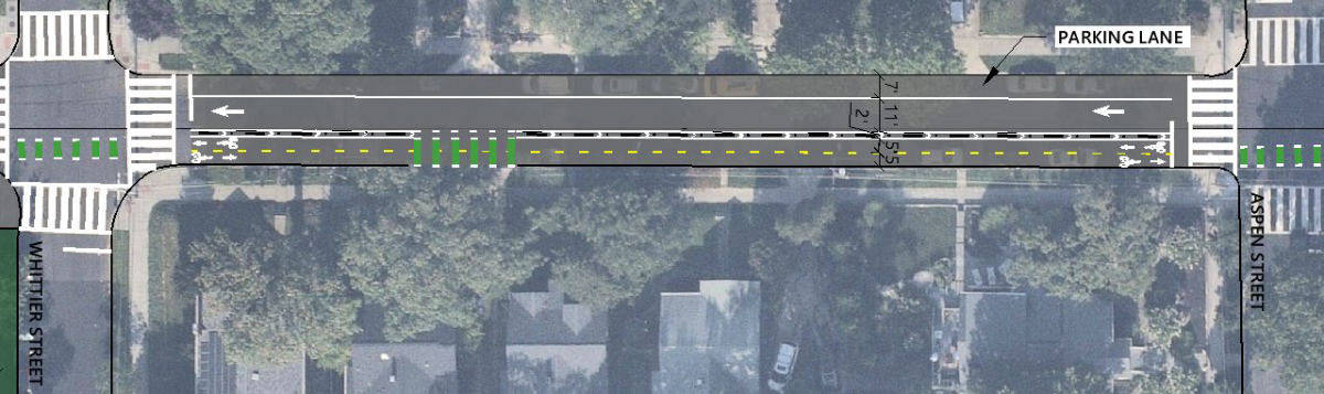
Issues with 4th Street to Blair Road connection
The final segment of DDOT’s design connects the MBT to Blair Road. At a prior community meeting, DDOT polled attendees on the design, and the top choice was to continue the two-way protected bike lanes from 4th Street onto Van Buren Street to Blair Road where there is a traffic signal to safely cross. DDOT’s own parking analysis showed that little street parking was used on Van Buren Street from 4th Street to Blair Road.
DDOT’s analysis of parking impacts for various MBT links to Blair Road. Image from DDOT. 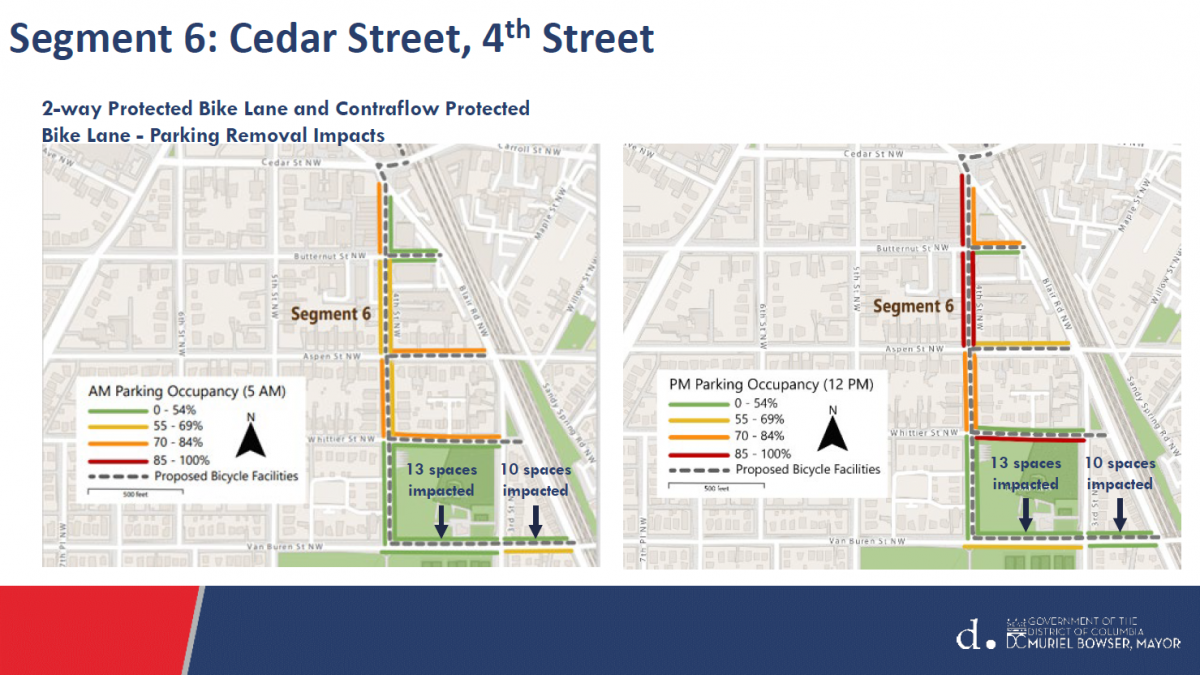
However, at a recent community meeting DDOT announced that it has decided to use Whittier Street and build the MBT on the sidewalk as a 10-foot shared use path, which will shrink to an 8-foot path once it crosses 3rd Street. DDOT’s design will remove of 18 trees on Whittier Street. DDOT said that MBT users seeking to connect to the protected MBT on Blair Road will be required to cross it without a traffic signal. Say what?
What could be better?
DDOT’s proposed MBT plans around Takoma are a mix of “the good, the bad, and the ugly.” Since DDOT has already finalized its plans from Fort Totten to Aspen Street, I will not propose an alternative for that segment. But DDOT’s initial design for the MBT from Aspen Street to Takoma Park is unsafe, expensive, and will take awhile to build — and there is a better way.
In part two of this series, I will offer alternative designs for DDOT to consider and give readers the opportunity to advocate for them.