Who holds the power in Prince George’s County depends on how its boundaries are drawn
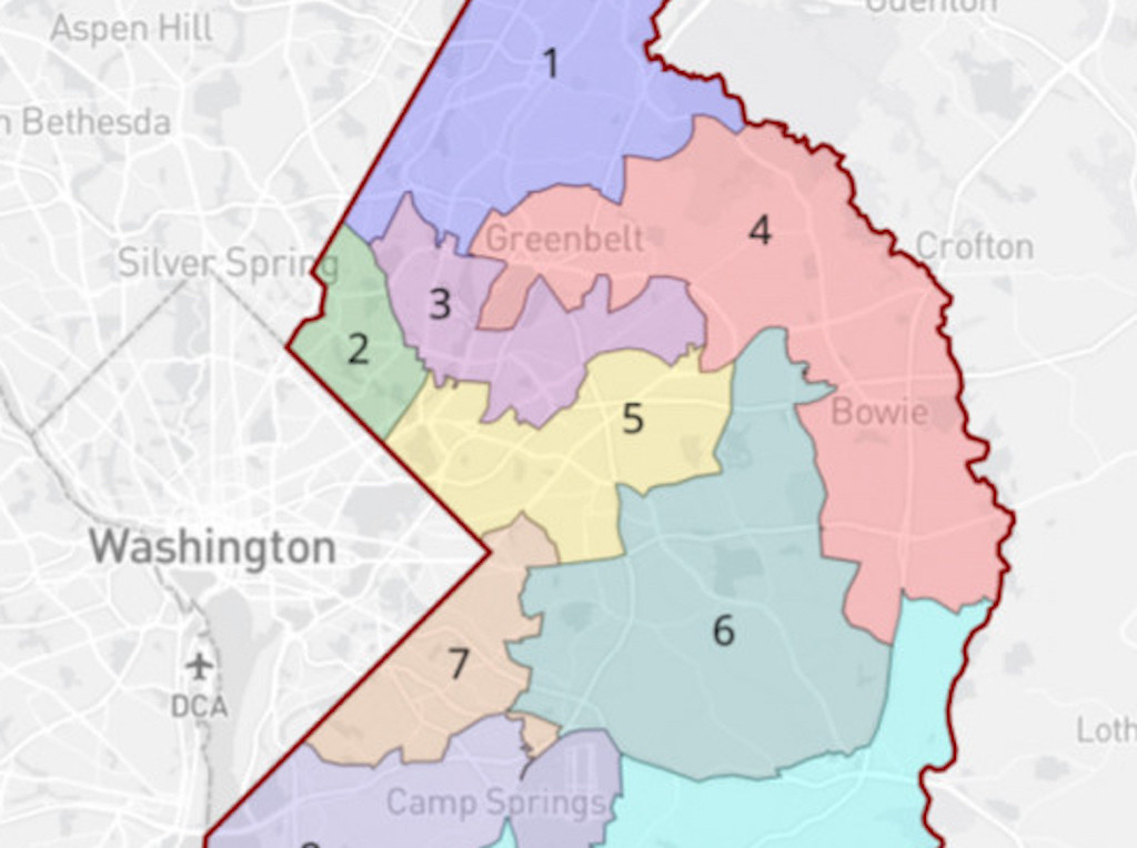
The current Prince George’s County Council districts, based on 2010 census data. Map drawn by DW Rowlands using the Dave’s Redistricting web tool.
The Prince George’s County redistricting commission is on track to submit its map of proposed county council districts based on 2020 census results to the council by the September 1 deadline. Redistricting is the process of redrawing legislative district lines, following the national census. It takes place every 10 years, at the federal, state, and local level, and each jurisdiction has its own unique rules and processes.
The way that district lines are drawn can determine who is eligible to run for office, what political party they are, whether certain neighborhoods or community interests will be adequately represented, and whether some Black, Latinx, and low-income communities will have a fair opportunity to elect representatives of their choice. (For a deeper dive on redistricting, check out the All About Redistricting website maintained by the Loyola Law School in Los Angeles.)
Unfortunately, the proposed map for Prince George’s replicates serious flaws in the current county council district map that harm low-income communities and increase the political power of the least-dense, least-urban parts of the county.
As two Prince George’s County residents with a keen interest in the redistricting process, we thought it would be helpful to do a series of articles that helps clarify and demystify the process and explain the impact it can have on our lives.
Redistricting in Maryland
Maryland’s statewide redistricting has been the subject of a great deal of media and academic attention, largely because of the way state lawmakers have historically drawn heavily gerrymandered congressional districts to ensure that seven of Maryland’s eight US House seats are likely to favor Democratic, rather than Republican, candidates. Several nonprofit groups, like Fair Maps Maryland and the Maryland League of Women Voters are taking on the task of educating Marylanders about issues relating to congressional and state legislative redistricting.
Similarly, Maryland Governor Larry Hogan has established an independent Citizens Redistricting Commission to assist him in drawing his proposed congressional and state legislative redistricting plans. The nine-member commission is composed of three Democrats, three Republicans, and three members affiliated with neither the Democratic nor the Republican parties.
The commission’s plans must adhere to a variety of nonpartisan traditional redistricting criteria, such as keeping districts compact and contiguous and respecting municipal and county boundaries. The commission plans to hold three rounds of public hearings (with multiple hearings in each round), receive public comments, and draft plans via electronic portal prior to finalizing its recommendations.
By contrast, it seems very little attention is being paid to the ways in which county and municipal legislative districts are being drawn in Maryland.
The redistricting process in Prince George’s County
In Prince George’s County, the county redistricting commission has been meeting since March. Two of its three members — former Maryland state senator David C. Harrington and former Prince George’s Community College president Dr. Charlene Mickens Dukes — were appointed by the Democratic Central Committee. (There are no Republican appointees, since the Republican candidates did not attain at least 15% of the votes cast in the 2018 County Council race.) The chair, Rev. James J. Robinson, was appointed by the County Council.
The redistricting commission is required by the county charter to make final recommendations to the county council for new districts by September 1, 2021. The county council will then have until November 30 to either accept the commission’s proposed map or to reject it and draw their own instead.
The redistricting commission initially announced that it would draw the new districts based on five guidelines:
- The new map must be a “least change map,” with the minimum changes to current districts needed to correct for population changes.
- All districts must share a common border. (This is required by the county charter, which requires “compact, contiguous, and equal in population” districts.)
- Precincts should not be split between districts.
- Each district’s population must be within 4.5% of the population of an “ideal” district with one-ninth of the county’s population. (This means a potential “maximum deviation” between the largest and smallest districts of about 9% of the ideal council district population, or about 1% of the total county population.)
- Districts will be drawn with “consideration of assets that connect districts.”
From the outset, the redistricting commission has been guided by one primary goal: “least change” — i.e., making only the minimum changes necessary to ensure that the population deviation among the existing council districts does not rise to the 10% threshold level where they would be legally presumed to be in violation of the “one person, one vote” principles inherent in the US Constitution. All of the suggestions for moving precincts that were proposed by the county council’s and redistricting commission’s hired consultant, Stanford University professor Nathaniel Persily, were made with that “least change” principle in mind.
Although the fifth guideline seems to suggest that the new districts might be drawn based on an assessment of how to best group related communities, in practice the first guideline (“least change”) constrains the commission to a plan very similar to the current districts based on the 2010 census.
The current Prince George’s County Council districts, based on 2010 census data. Map drawn by DW Rowlands using the Dave’s Redistricting web tool. 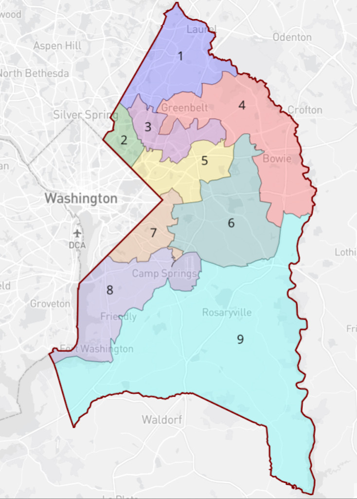
Furthermore, the current districts — especially Districts 3, 4, 5, and 8 — are not particularly compact, and do not represent particularly coherent portions of the county. In particular, several districts contain substantial areas both in the low-income, more-urban areas inside the Beltway and the higher-income, less-urban areas outside the Beltway, and all four of the county’s Metrorail lines are split into several districts.
The 2011 redistricting commission proposals were overturned by the county council
It is worth noting that the county’s current districts are not based on the recommendations of the 2011 redistricting commission, which drew districts based on the 2010 census data.
The 2011 commission completely redrew the council districts with a goal of not splitting municipalities and census-designated places. The resulting map made substantial changes to district shapes and, in particular, made District 3 much more compact.
In their full report, the 2011 commission argued that, while the districts drawn in 2001 formed a good basis to work from, it would be beneficial to make more-compact districts that avoided splitting municipalities and census-designated places, many of which were broken up into two or more districts in the 2001 map.
They also noted that there was no need to avoid splitting precincts, since the Board of Elections would redraw them after county council, board of education, state legislature, and Congressional districts were drawn.
The 2011 redistricting commission’s proposal, based on not splitting municipalities and census-designated places. It was rejected by the county council. The original can be found on the Internet Archive. 
However, the county council rejected the 2011 commission’s proposal. They saw the proposed districts as too different from the then-existing districts (based on 2000 census data), and felt that census-designated place boundaries were not meaningful or reflective of actual communities.
The council drew its own redistricting map based on 2010 data, with relatively little change to the 2000 districts. The City of Bowie, however, which had previously been divided between Districts 4 and 6 was merged into a single district. This background seems to have informed the current redistricting commission’s decision to create a “least change” plan.
In our next article we will look at the 2021 proposed map for Prince George’s and its possible impact on the residents of the county.