A new map shows where DC sidewalks are wide enough to socially distance

A map of sidewalks around Bloomingdale. All maps by the author using Mapbox GL JS.
Cities around the world are asking residents to practice social distancing, remaining six feet or more from other people. But where, exactly, can we safely practice social distancing?
Inspired by a similar map in New York, I made an interactive map showing how wide are various DC sidewalks, and whether they are wide enough for social distancing.
Walking around DC the last few weeks, two things have become readily apparent. First, people are genuinely trying to be responsible and practice social distancing by giving each other space on the city’s sidewalks. Second, in just about any neighborhood, this is harder than many people might imagine.
In Dupont Circle, where I live, I noticed people routinely moving off the sidewalks into the street to avoid other people. While considerate, people should not have to make an on the fly mental calculation between potentially exposing themselves to COVID-19 or stepping into traffic.
That’s why I found it so interesting when last week, Meli Harvey, an urban planner based in New York, published the site sidewalkwidths.nyc.
New York’s Financial District by the author.
This interactive map highlights which sidewalks pedestrians might have an easy time social distancing, and which sidewalks where this would be challenging, if not impossible. Helpfully, not only did Meli publish the site, but they shared their code on GitHub and encouraged others to adapt it for their cities.
Based on Meli’s work, I was inspired to create Side Walk Widths DC.
A map of sidewalks near Trinidad in DC by the author.
Using Open Data DC’s planimetric sidewalk dataset and the code behind sidewalkwidths.nyc, the map highlights sidewalks throughout the District and categorizes them by relative ease of social distancing based on their width. For the purposes of this map, social distancing categories are based on the width of each section of sidewalk and correspond to a specific color.
Red segments indicate that a sidewalk is under six feet in width and virtually impossible for social distancing. Orange and yellow segments indicate social distancing may be difficult, while green and blue segments represent wider sidewalks where social distancing should be easiest.
The broad categories are intended to help give people an impression about how easy or difficult it is to safely walk in different parts of town. Even if sidewalks are wider than six feet, on the ground conditions like utility equipment, signage, or other obstructions may make social distancing difficult.
Looking at the map, red is by far the dominant color. It’s immediately clear that most residential areas of town have overly narrow sidewalks, often six feet or less in width.
A map of sidewalks near East Capitol Street by the author.
In fact, Downtown DC and the National Mall are some of the only places with a high density of sidewalks greater than 12 feet in width.

This is great if you happen to be the area, but many neighborhoods where people are actually spending time or performing short essential trips do not have pedestrian accommodations where safe social distancing is possible.
How much do wide sidewalks on commercial corridors like H Street or 14th Street matter, if all of the sidewalks leading to them are less than six feet wide?
A map of sidewalks near H Street and 14th Street by the author.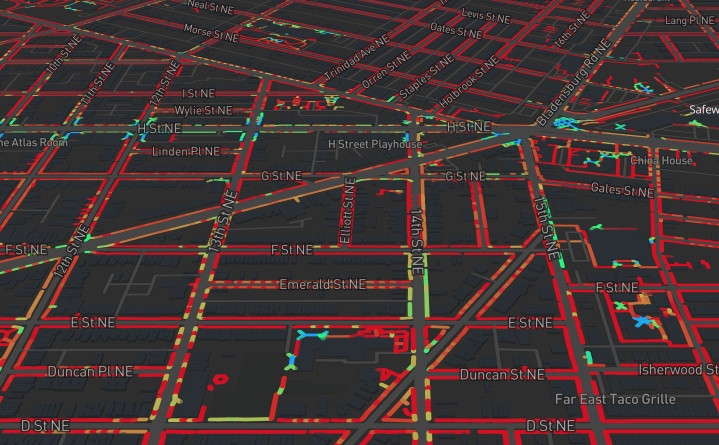
Hopefully, this map can help benefit residents in two ways. First, it can help validate people’s experiences walking on DC’s sidewalks. Narrow sidewalks not only impede social distancing, but are dangerous places to walk in general, keeping pedestrians closer to traffic. Second, the map can help people recommend and advocate for sidewalk improvement projects.
Last week, the Bowser administration took a few small steps towards answering the public’s call to extend sidewalks throughout the District. The District Department of Transportation (DDOT) will temporarily extend sidewalks near retailers and grocery stores to allow more space for social distancing. It is hopefully the first step in a wider effort to give residents more space to safely move about town. The administration is directing residents to contact their ANC commissioners for specific locations.
While not enough on its own to prioritize sidewalk improvements, combined with residents’ input and other city datasets, this map can help show the need and focus people’s attention on specific problem areas. With additional effort, this resource could keep expanding to neighboring jurisdictions, and cities around the country.