Long ago, Baltimore had an elevated streetcar along Guilford Avenue

A streetcar on the Guilford Avenue elevated in Baltimore, which ran along Guilford Avenue from Chase Street to just north of Lexington Street from 1893 to 1950.
Recently I wrote about tunnels under DC, including three short tunnels built for the District’s streetcar network in the first half of the 20th Century. While Baltimore’s streetcar network never included tunnels, from 1893 to 1950 the city did have an eight-block elevated trestle for streetcars, including several stations along Guilford Avenue.
The Guilford Avenue Elevated ran above Guildford Avenue (next to the current route of I-83) through downtown Baltimore from Chase Street to just north of Lexington Street. It opened in May 1893 as a portion of the route of the Lake Roland Elevated Railway, an extension of the city’s first electric trolley line, the North Avenue Railway, into downtown Baltimore.
Baltimore’s Guilford Avenue Elevated
A 1913 map of the Baltimore streetcar system, with the Guilford Avenue el colored red. Image by McGraw Electric Railway Manual, 1913.
Streetcar tracks on Guilford Avenue had to be elevated because the street was already host to the tracks of the Northern Central Railway, a subsidiary of the Pennsylvania Railroad. (You can see them here on “North Street,” now Guilford Ave.) These tracks connected the railroad’s east-west tracks near the current location of Penn Station to Calvert Street Station on the site of the current Baltimore Sun building at East Franklin and Calvert Streets.
Despite it already hosting tracks, the Lake Roland Elevated Railway company decided to build along Guilford Avenue because nearly every street running into the central business district from the north already had streetcar lines from competing companies.
Although the elevated section of the line only ran for about eight blocks, it appears to have had three stops. There were small platforms with shelters accessible by metal staircases at Madison, Centre, and Pleasant Streets. You can see these stations if you zoom in on this aerial photo of Baltimore from 1927. They’re also marked on this 1945 map of the city’s streetcar network.
The route of the Guilford Avenue el with the locations of likely stations, superimposed on a map of downtown Baltimore from OpenStreetMap.org. Image by the author.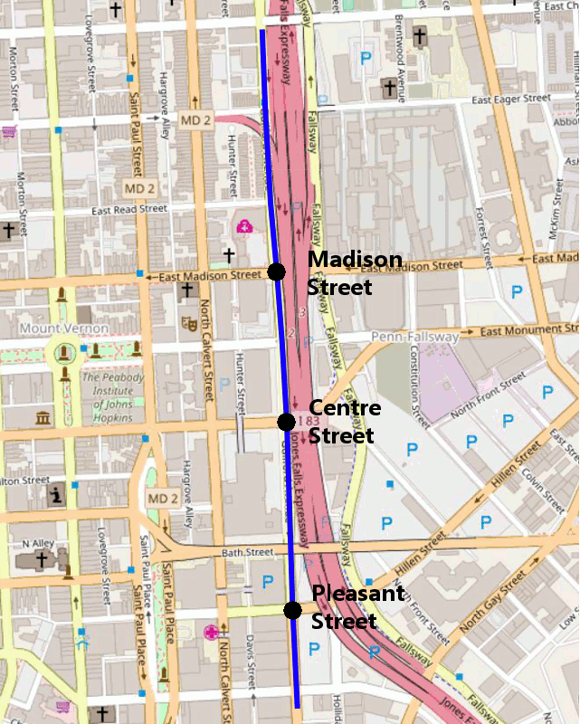
The Pleasant Street station’s platforms can be seen in this photo of the el looking south toward Saratoga and Lexington Streets. They appear to have been at track level, and had small shelters with roofs.
Rapid transit in Baltimore, or what could have been
Although the Guilford Avenue Elevated gave Baltimore one of the first rapid transit lines in the county, it was very short, with only three stops along an eight-block route. No more elevated or subway lines were built in the city during the streetcar era.
However, the city did float a proposal in the late 1920s during Mayor Frederick Broening’s second administration to reroute the B&O Railroad trains running through the city from the Howard Street Tunnel to an elevated right-of-way along Pratt Street so the tunnel through downtown could be used for streetcar service.
The el was eventually demolished in 1950 as part of the effort to replace Baltimore’s streetcars with buses by the Baltimore Transit Company. The conversion finished in 1963.
In 1965, Baltimore received Federal funding to study a regional rapid transit system. The resulting 1968 report proposed a 71-mile system with six branches radiating from downtown. Had that system been built, Baltimore would have had a subway system comparable to Metro, which began construction in 1969.
A map of the 1968 proposed Baltimore rapid transit system. Image by Baltimore Metropolitan Transit Authority.
Unfortunately, rather than approving the entire system at once, as was done with Metro (partly to ease concerns from the region’s many jurisdictions that a one-line-at-a-time approach would leave them paying for a train that never reached them), Baltimore proposed a 28-mile initial plan in 1971. This plan consisted of a northwestern line similar to the Baltimore Metro Subway that was eventually built, as well as a southern line similar to route of the Baltimore Light Rail south of downtown.
The southern branch of the proposed subway was eventually cut because Anne Arundel County residents, who it would have served, opposed it. However, about a decade later, the Baltimore Light Rail was built along the proposed right-of-way of the southern subway line. It also had a northern line similar to the original proposed northern subway line, but lack the proposed connection through Towson.
Sources:
While the Guilford Avenue el does not have its own entry on Wikipedia, there are a number of references to it online. I also consulted several books while writing this article.
Who Made All Our Streetcars Go?, by Michael R. Farrell is a detailed history of Baltimore’s streetcars, and seems to be the best source on the Guilford Avenue el. It was later republished as The History of Baltimore’s Streetcars, and may be easier to find under that title.
Small Town Baltimore: An Album of Memories, by Gilbert Sandler has a short discussion of the Guilford Avenue el, although it gives a different list of stations (Madison, Monument, and Centre, but not Pleasant) than I found from aerial photos and maps.
In addition, I’d like to thank Alexander Rapp, creator of this series of rapid transit timeline maps for help in finding source maps of the Baltimore streetcar network.
This article was first published on July 31, 2018. It’s interesting to look back at the region’s history, so we are sharing it again.