Will development at the Armed Forces Retirement Home mesh with the city, or be another planning disaster?

The federal government has a deal with a development team to build virtually a whole new neighborhood on a portion of the Armed Forces Retirement Home, the large 272-acre estate off North Capitol Street. So far, we otherwise don’t know a lot about what they’re planning, and what happens could be great for DC or deepen what’s already a cluster of examples of atrocious planning.
Meet DC’s non-planning disaster zone
The area along North Capitol Street and Irving Street is a little bubble of totally suburban roads and buildings. There’s DC’s only cloverleaf interchange, hospitals surrounding by big parking lots, and some housing complexes laid out around a loop or cul-de-sac with just one road in and out.
The area is quite inhospitable (though quite hospital-able) on foot or bike. To the west is the street grid of Park View; to the east, the grids of Brookland and Edgewood; to the south, Stronghold. But there’s this netherworld in the center that’s the Land That Planning Forgot.
Image by Google Maps.
The neighborhoods on each side have good sidewalks, intersections easy to cross on foot and bike as well as car, and various bus lines. In the middle, there’s none of that. While there are some token sidewalks, walking or bicycling along the cloverleaf area is circuitous and harrowing.
Planners (today, anyway, and in the 19th century) understand that grids bring enormous advantages. They spread out traffic among different roads, and give people shorter travel paths instead of forcing them the long way around. Grids work far, far better for transit service, so that buses can travel right through an area and stop where people are going instead of having to just touch the edge. But grids happen because cities plan for them, not just on their own.
At Tysons, Fairfax planners are trying to create more of a grid where there isn’t much of one around it. Along North Capitol is a case study in what happens when, despite having grids on either side, there’s a combination of bad mid-century planning and no planning at all.
From Soldiers’ Home to suburban-style experiments
Why is this? It’s all land that was once part of the Riggs Farm and then the Old Soldiers’ Home. Now known as the Armed Forced Retirement Home-Washington, this federal facility has been serving resident retired and disabled veterans since 1851. Abraham Lincoln spent much of the Civil War there and wrote the first draft of the Emancipation Proclamation in the historic Anderson Cottage.
This 1948 map shows the home’s land extending all the way to Michigan Avenue, encompassing what’s now the hospitals and housing complexes. That part of the land was a dairy farm and orchards. North Capitol Street ended at the south edge rather than running through, and there was no Irving Street and no cloverleaf.
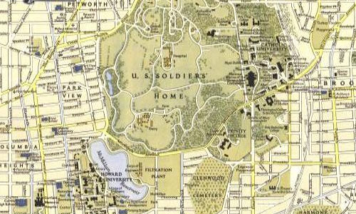
National Geographic 1948 map, detail around the AFRH.
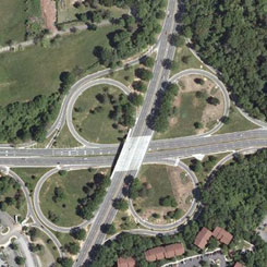
Where Irving and North Capitol meet is a large suburban-style cloverleaf interchange. It’s the only full cloverleaf in DC and a relic of a time when people assumed that freeways would cut through most District neighborhoods.
As Kent Boese explained, these roads came from a 1950s and 1960s effort to build a north-south and crosstown freeway. In Park View and Columbia Heights planners decided to create the pairs of one-way streets we have today, and to get federal aid, had to widen some streets by only a foot, removing all the street trees to do it. Shortly thereafter, public and official opinion turned against the freeway-building efforts, and most were shelved, leaving this isolated vestige of bad ideas in this spot.
AFRH looks to development
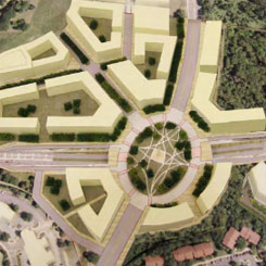
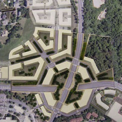
The home, merged with a Mississippi naval home in 1991, operates as an independent federal agency with its own trust fund. That fund wasn’t enough to keep the home operating, so in 2002, Congress authorized leasing some of the land to raise funds to keep the home afloat. A 2008 Master Plan proposed carving out 80 acres on the southeast corner, along North Capitol Street and Irving Street, for the development.
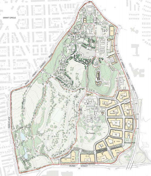
Possible layout of future buildings, from the 2008 master plan.
Not much happened for a decade. Then, the federal government posted a soliciation in 2018 for developers and, late in 2019, selected a team of Madison Marquette and Urban Atlantic. Not that much more is known, yet, about what the winning bidders proposed doing on the site.
But the 2008 plan is twelve years old, and that shows. Some major things have changed, which the plan doesn’t address. Finally, the DC government and feds have been battling over whether local planning and zoning review will apply.
Will the complex be another inward-facing, isolated dead end?
Look at that road diagram. It has something of a grid, but there are still just two roads in and out. Traffic will back up. People walking will have to get to those entries and exits, which aren’t that close, and then battle along the harrowing freeway-like streets.
And what about transit service? The H buses travel along Michigan Avenue here with a detour into the hospital center, while the 80s use North Capitol but turn onto Michigan. Will any bus service be modified to serve AFRH? If so, will people have to walk out of their gated community to get on and off?
Will North Capitol and Irving change?
Some of these design decisions are logical if you assume you’re building something pinned between two freeways and a closed-to-the-public golf course. But how long will that continue?
In 2009, the year after the Armed Forces Retirement Home finished its Master Plan, the National Capital Planning Commission and the DC Office of Planning came out with their own study of North Capitol Street. The study recommended making North Capitol more of a “boulevard” south of the cloverleaf and a “parkway” to the north, by AFRH.
It also considered ways to replace the cloverleaf with an intersection more appropriate to DC, such as a circle.
The four options from the OP/NCPC study. Left to right, top to bottom: The current North Capitol interchange, the “parkway/memorial,” the “circle,” the “four corners.”
That study, too, led to no action for a while, but the District Department of Transportation studied this area in 2016 in their Crosstown Multimodal Transportation Study. That study recommended several changes, including dedicated bus lanes on Columbia/Irving (in Park View and Columbia Heights) and Michigan Avenue in this area; a two-way protected bikeway on Irving Street; and replacing the cloverleaf with two traffic lights and one connecting road in the northeast.
Crosstown study recommended projects by DDOT.
Taking away the cloverleaf would give even more land for AFRH and the development team to build on, so they might be able to really take advantage of this. Beyond just building more here, though, there’s an opportunity to also build something that turns less of a back to these roads.
Like the diagrams from the 2009 study show, there could be corresponding development on the southwest (hospital) and southeast corners. There was zoning approval for a hotel, residential, office, and a conference center, which was in limbo as of September 2019, but that design also walls itself off from the cloverleaf area instead of possibly integrating with something new that could be built there.
It’s not a surprise that everyone’s designing this way, since there is a cloverleaf. There’s a plan not to have one, but no actual project to remove it. This creates a planning chicken-and-egg situation, where architects design buildings compatible with a cloverleaf but then building those makes it harder to have a non-cloverleaf.
Similarly, Catholic University could build on land east of North Capitol, which the home sold to the university in 2002. Would it assume a freeway (since there’s one now), or more of a boulevard integrating with AFRH on the other side, which could be?
How about some planning?
When there’s a lack of planning, one could turn to a DC agency well suited for that kind of thing, the Office of Planning. And it’s girding for this: in the updates to the Comprehensive Plan, OP circled this area as a “Future Planning Analysis Area.”
AFRH area on the proposed Generalized Policy Map by DC Office of Planning.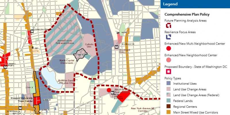
This says the agency hopes to give this area, from the McMillan filtration plant in the south to AFRH and Catholic University, more attention.
Text in the plan says about this area,
Future private use redevelopment at AFRH should create a new well-integrated mixed-use neighborhood that can contribute to the vibrancy of Washington, DC and help the city meet major priorities such as new housing opportunities for its growing population, including affordable housing; new commercial and retail space that generate new jobs; and supportive infrastructure for multi-modal transportation.
Private use redevelopment of AFRH should physically engage with the city and invite people into the site. Develop a neighborhood that is designed to prioritize transit, walking, and bicycling, consistent with recommendations in the Crosstown Multimodal Transportation Study. Internal street designs should reflect current best practices and connect with the existing public street network to enhance access along and across Irving Street NW and North Capitol Street.
The 2008 Master Plan spends a lot of time on historic preservation matters to ensure development is “compatible” with the existing AFRH campus, such as landscape design, signage, etc. but very little time on activating public space, integrating with the city, and so forth.
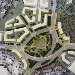
Rendering of the proposed development by AFRH/Madison Marquette via WBJ.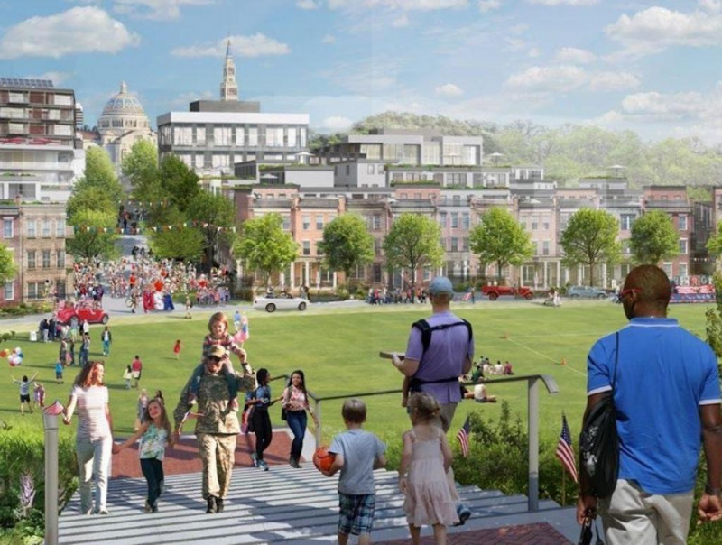
This rendering, one of a few released in November, certainly looks like an active, energetic public realm. It certainly could be, though seeing the plans in more detail will allow planners to better actually answer that question.
The National Capital Planning Commission, the federal planning agency for the area, also can play a role and will be hearing about this project in March.
Will DC get shut out?
A big question, however, is whether the federal government will sideline DC’s planning entirely. In 2018, AFRH announced it would not go through the District’s processes for approval for the site, and instead use the systems federal agencies use to get their own projects reviewed and approved. The District fired back, saying AFRH can’t just use its federal status to bypass DC approvals for a private development.
What will happen is unclear. AFRH CEO Steve Rippe said the home would “continue to work cooperatively” with the District, and the District retains authority over items including road connections to the street grid.
When I wrote a similar article in 2015, DDOT’s Sam Zimbabwe said they “will be working with [AFRH] on a comprehensive transportation report (CTR),” which for a project of that size, “can often take years and multiple iterations.” A 2017 Supplemental Environmental Impact Statement also notes the project expects to develop a Transportation Management Plan. It seems likely that the project will work with the District on transportation, but how much it needs to heed officials’ comments isn’t clear.
Nor is it clear whether AFRH has to comply with District law about things like percentages of affordable housing. The District has a law, for instance, mandating a higher amount of affordable housing (30%) for development on public land. Should AFRH have to include 30% affordable housing?
The development also does have the potential to bring much-needed more housing units to the District.
Many of these questions hinge on what kind of proposal the winning bidders made. AFRH and the General Services Administration, which managed the solicitation, are primarily concerned with maximizing the revenue they earn. Will the project also exhibit exceptional urban design and meet DC’s goals stated in the Comp Plan, like housing and affordable housing, jobs, and to “physically engage” with the city? Or will it make AFRH the most money at the cost of negative externalities to the area?
We may get a better look when NCPC hears a presentation on March 5.