How well is the region doing at planning for growth near Metro?

Transit-oriented development near the Shaw Metro station in DC. Image by Tim Brown used with permission.
While sprawl incentivizes people to drive cars and contributes to traffic, building a lot of homes, shops, and other amenities around Metro stops and other transit nodes is a more sustainable method of development. This approach, called transit-oriented development (TOD), allows more people to walk to their destination and use buses and trains to get around.
Many local jurisdictions have started to adopt this transit-oriented development approach by upzoning, or allowing more density, on land near the region's 91 Metrorail stations. However, there is still a lot of room for improvement—and I've found that some stations and jurisdictions are doing much better than others.
In this post I'll take a closer look at why international TOD prodigy Arlington County comes in last at first glance; why the urban core at the heart of the Metrorail system, the District of Columbia, had seven out of the top 15 most restricted stations; and why Montgomery County can and must do better at stations like Forest Glen.
Zoning for transit-oriented development
My recent look at zoning in the DC metropolitan area revealed that a whopping 74% of our region's land area is zoned exclusively for detached single-family homes or open space. At the regional level, however, this figure doesn't mean much—is it good or bad? It depends on how this lowest-intensity zoning is distributed spatially in the region.
Here's the map when we only look at land within a half-mile of an existing Metrorail station.
Image by the author..png)
Crunching the numbers behind this visual produces some juicy statistics.
Jurisdiction |
% Open Space |
% Detached SF |
% Everything Else |
|---|---|---|---|
| City of Alexandria | 3% | 8% | 88% |
| District of Columbia | 14% | 9% | 76% |
| Fairfax County | 0% | 25% | 75% |
| City of Rockville | 1% | 28% | 71% |
| Prince George's County | 9% | 23% | 67% |
| Montgomery County | 0% | 39% | 61% |
| Arlington County | 37% | 14% | 49% |
| Region | 13% | 17% | 70% |
The City of Alexandria is number one in the region for upzoning near Metrorail. Montgomery County restricts more land within a half-mile of Metrorail for single-family homes than any other jurisdiction. Cross-referencing this table with the map reveals that some areas need a closer look.
Fairfax County has done a great job of upzoning Tysons Corner, but West Falls Church (which is not actually in the City of Falls Church, and is therefore zoned by the county) in particular looks like a missed opportunity.
Similarly, the District would have been number one for TOD, but for exclusionary zoning around Red Line stations in the Northwest quadrant (specifically Cleveland Park, Van Ness-UDC, Tenleytown-AU, and Takoma).
Why didn't Arlington do better?
When you look up TOD on Wikipedia, Arlington County is there. But so are detached single-family houses. Image by Arlington County licensed under Creative Commons.
Literally, the picture on the TOD Wikipedia page is one of Arlington County. So how did Arlington County come in dead last among area jurisdictions for upzoning near Metrorail?
First, you've got to play the hand you are dealt. Of the county's 11 Metrorail stations, three of them are almost completely surrounded by special land uses that Arlington zones S-3A. While the county says the purpose of this zone is “to encourage the retention of certain properties in a relatively undeveloped state,” this zone also contains the Pentagon, National Airport, and Arlington Cemetery. The first couple are two of the biggest employers in the region, and clearly part of TOD is locating employment near transit (or vice-versa).
However, dropping these three stations from the analysis only raises Arlington's “everything else” average to 59%. That's because East Falls Church, where most of the half-mile radius falls within Arlington, is #6 out of 91 Metrorail stations for single-family zoning, at 61.4%. That drags down the average of TODs like Ballston.
However, the reality is that Arlington's TOD reputation may also be somewhat oversold relative to Alexandria and DC—just look at that 38% detached single-family housing around the Clarendon station.
Montgomery County: in last place for TOD?
Montgomery County does not have an open space zone other than the agricultural reserve, so it doesn't have an Arlington Cemetery-type problem dragging down their upzoning averages. However, while the county has the highest rates of single-family zoning near Metrorail, that doesn't mean that detached single-family houses actually occupy all of that land.
Many institutional land uses, such as schools, are allowed by-right in most single-family zones, so this statistic for Montgomery County merits a closer look. For example, the #1 station in the region for single-family zoning is Medical Center. However, even if you've never been there, just reading the name makes it pretty easy to guess what's around there:
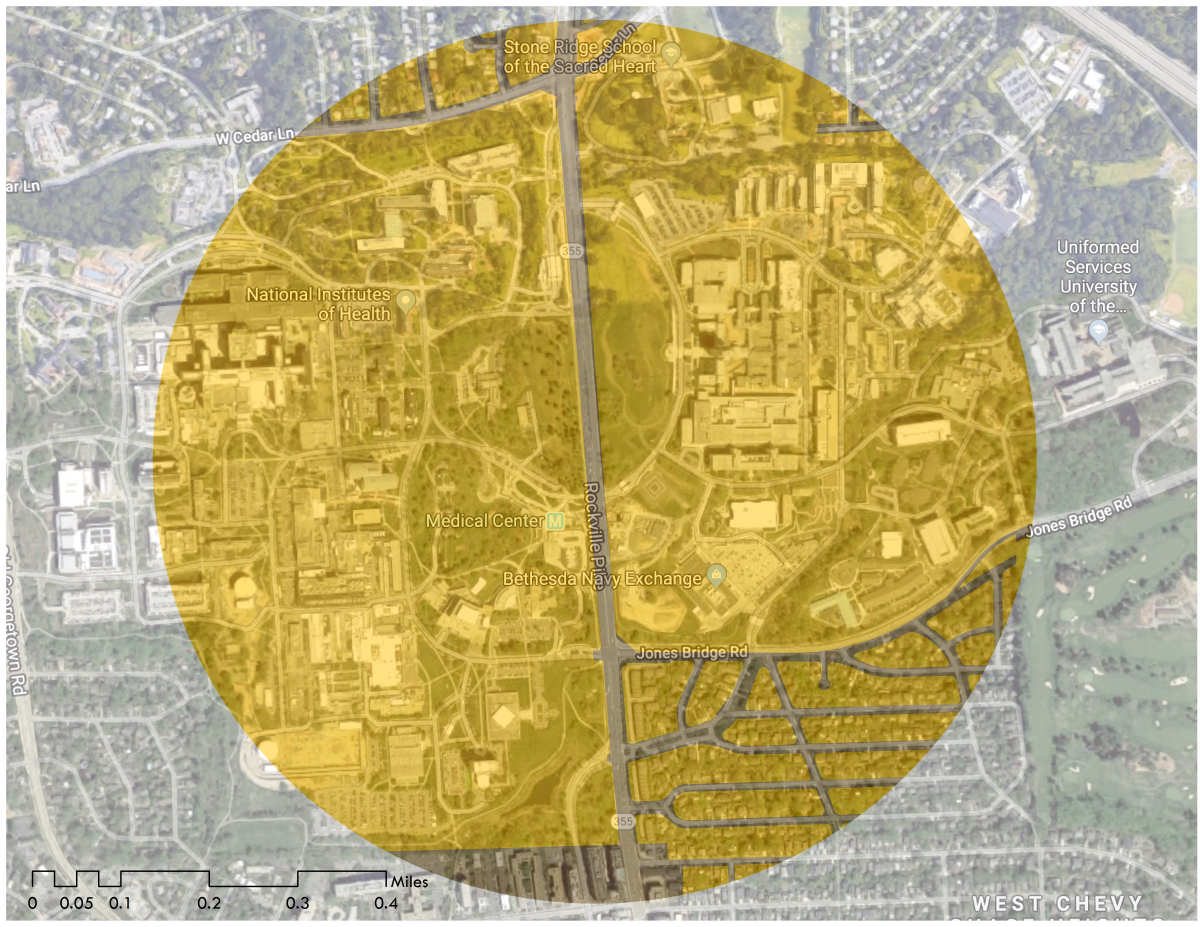
It's the campuses of the National Institutes of Health and Walter Reed National Military Medical Center, home to, among other things, the Uniformed Services University of the Health Sciences (aka the medical school of the armed services). The land underneath these institutions is zoned for detached single-family homes, but in reality locating Metrorail near these major employers checks a TOD box.
While there are still detached single-family homes cozily within walking distance of the Medical Center station, this is not what's hurting Montgomery County's TOD opportunities the most. That's Forest Glen and Takoma, as well as Glenmont and Grosvenor-Strathmore, which are also dangerous for people walking and bicycling.
This single family home in the Takoma neighborhood of DC is two blocks from the Takoma Metrorail station. Image created with Google Street View. 
The award for most single-family homes near Metrorail goes to: Takoma
The District of Columbia and Montgomery County split responsibility for the zoning around the Takoma Metrorail station. However, on both sides of the border it's almost all zoned for detached single-family homes, except for the central splotch occupied by some industrial buildings, two commercial rows, and Takoma Village Cohousing.
Image by the author.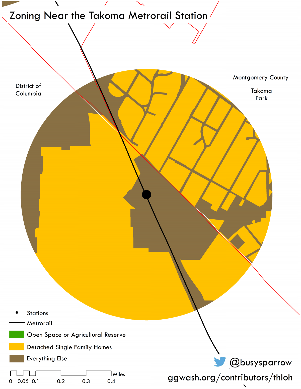
When looking at stations like Takoma and Forest Glen in a vacuum, it's easy to say it doesn't make sense to have all these single-family homes near a community investment like Metrorail. However, the vast majority of these houses predate the Metro. So the issue is not so much that these houses exist, but that the zoning of the land they stand on restricts them from ever changing—even to something incrementally denser like townhouses—without the risk of litigation.
We have taken the first step towards transit-oriented development by making a transformative investment of time, money, and planning effort to build a transit system. However, we cannot reap the full reward of that investment until land use evolves in response.
In a follow-up post, I hope to overlay this analysis with some data on home prices. While not publicly available, I have contacted a private-sector aggregator with a request—inquiring minds want to know!