Here are the answers to whichWMATA week 134
On Tuesday, we featured the 134th challenge to see how well you know the Metro system. Here are the answers. How'd you do?
This week, we got 36 guesses. Fifteen of you got all five. Great work, ArlFfx, Mike B, Rick, Kevin M, AlexC, McLovin, Peter K, jimble, Mensches on Benches, Ginger, MtPDC, Jay H, Patrich B, J-Train-21, and Tom Q.!
This week, the whichWMATA series featured stations seen with a portion of their entry pylon visible. This generally meant that you could see some of the station's surroundings, with the exception of image 5.
Image 1: Bethesda 
The first picture looks into the plaza atop the bus loop at Bethesda station. As noted by several of you in your guesses, the artwork here is fairly distinctive, and should have helped you narrow this down. We've featured this artwork several times.You might have also recognized the Bethesda Hyatt, visible at left.
Thirty of you knew this one.
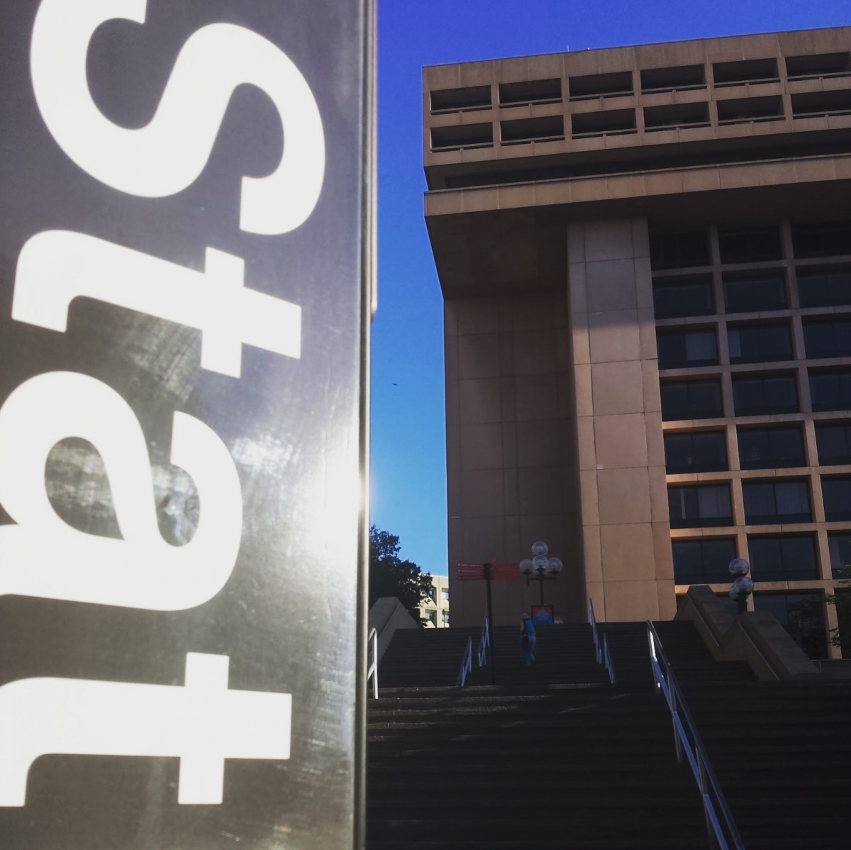
Image 2: L'Enfant Plaza
The next image shows a view of the westernmost entrance to L'Enfant Plaza station from D Street SW. Visible in the background is the East Building at L'Enfant Plaza, which is fairly distinctive, though DC does have quite a bit of mid-century Brutalist architecture, Metro included. The stairs leading up to the promenade are directly above the escalators (not visible) that lead down to the western mezzanine/Huntington platform. Access to the station is to the right at the first landing.
Thirty of you got this one right.
Image 3: Capitol South 
The third image shows a simple uncovered Metro escalator shaft surrounded by rowhouses. Several Metro stations are placed in settings like this, but the lack of an escalator canopy, like at Eastern Market, narrows the field a bit. The real clue here is the pair of smokestacks visible in the distance. These serve the Capitol Power Plant on E Street SE, a block and a half south of the station entrance. While the plant is called a power plant, it actually hasn't supplied electricity to the Capitol complex since 1952. It does provide steam and chilled water to the complex, which includes the Library of Congress, the Supreme Court, and the House and Senate Office Buildings.
Twenty seven of you figured this one out.
Image 4: Shaw 
The fourth image shows a view looking east on R Street outside the Shaw station's southern entrance. Visible at right is the Shaw Neighborhood Library. In the distance is the intricate facade of the Asbury Dwellings, located at Rhode Island Ave and 7th Street. Keen observers could probably narrow this down by noting the typical DC-style traffic signals at the intersection. Recognizing the library or other surrounding buildings probably was the key for most of you.
Twenty seven of you guessed correctly.
Image 5: East Falls Church 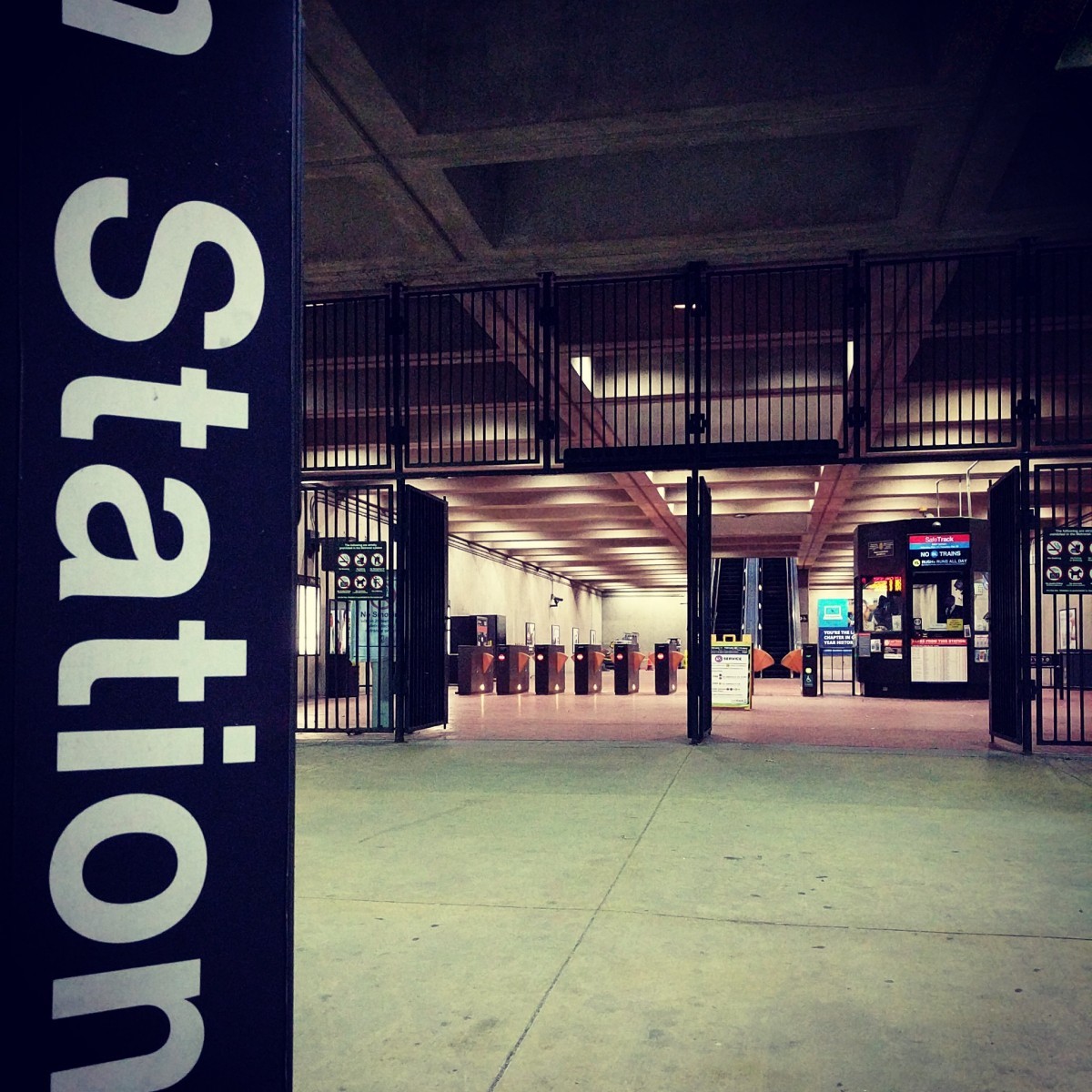
The final image shows the entrance to East Falls Church station. While this mezzanine is similar in style to others, it does have a somewhat unique design since it's located beneath a station in a freeway median. Careful attention to detail should have guided you toward the correct answer.
From the image, you can tell that this station has platforms above the mezzanine, which eliminates all the underground stations. That reduces the possibilities from 91 stations down to 28. We can also tell that there's a single center platform, instead of two side platforms. That cuts the possibilites down to 25.
Another way to solve this is to look at the subtle clue at the top of the frame. As Peter K noted, you can see a portion of the last letter of the station's name. This was intentional to make it a little easier. You can tell that the last letter of the station name is either a lower-case “h” or “n”. Only 18 stations have names ending in “n” or “h”. Keep in mind that some stations, like West Falls Church, actually don't fall on this list, because the last letter in the official name of West Falls Church is actually a capital “A” (the last letter in UVA). Gallery Place is on the list, despite seeming to end in an “e”, because “Chinatown” is also in the name.
If we compare the list of 25 above-ground, center-platform stations with the list of 18 stations ending in “h” or “n”, we have just 6 stations to examine: East Falls Church, Fort Totten, Huntington, King Street-Old Town, McLean, and New Carrollton.
We can discard McLean because the pictured station doesn't match the architectural styles of the Silver Line. New Carrollton isn't a possibility because the entry to the station mezzanine is from a tunnel under the Orange Line and Amtrak tracks, and the pylons are located out by the bus loops on either side. At Fort Totten, a view from this location would reveal the underside of the northern set of escalators leading from the Red Line to the mezzanine, and the ceiling is significantly different.
King Street and Huntington both have an entrance accessed from under the tracks and platform. However, at King Street, the main entrance is accessed from the bus loop on the side of the station, and the minor entrance that's under the tracks was added recently, looks different from this, and doesn't have a pylon. Huntington's northern mezzanine is significantly higher than East Falls Church's, and doesn't match the picture. That leaves East Falls Church as the only possibility.
Eighteen of you came to the correct conclusion.
Great work, everyone. Thanks for playing! We'll be back in 2019 with challenge #135.
Information about contest rules, submission guidelines, and a leaderboard is available at http://ggwash.org/whichwmata.