Is the Washington region prepared for storms like Hurricane Florence?

DC storm, looking south from Courthouse towards the Air Force Memorial by Jeff Morrow used with permission.
Hurricane Florence is finally spinning away from the Carolinas, leaving a destructive wake that includes at least 32 people dead. The threat had governments in the Washington region engaging their emergency management plans and assessing how they would act in the case of a direct hit.
An old hurricane plan for the DC Metro area dated to 1963 lists a lot of the same risks the city faces today, like tidal flooding related to the storm surge, though climate change has made them more acute. At the time, the Army Corps of Engineers advocated for flood control plans, and while local governments have been making efforts to prepare for dangerous weather in the decades since, gaps still remain.
Jurisdictions are trying to plan for destructive weather
Regular flooding in places like Ellicott City, in Old Town Alexandria, in Rock Creek Park, and elsewhere around the region are a constant reminder of how vulnerable the region is to hurricanes and other storms.
When destructive weather is anticipated, governments may engage their emergency management plans. These set out a basic timeline and instructions on how to execute a safe and orderly evacuation from dangerous areas, and shelter management for those who cannot leave. They also cover preparation for emergencies, technical communications, search and rescue, incident command and interagency coordination, as well as recovery efforts like debris removal and getting businesses back up and running.
Most area governments coordinate under plans prompted by various rounds of congressional oversight and inquiry. Most base their plans on the Department of Homeland Security (DHS) National Response Framework, which covers topics from “large-scale terrorist attacks or catastrophic natural disasters” and is updated every three years. (The most recent one is from 2016.)
Local governments also use the National Incident Management System and Incident Command System, established by FEMA, as the basis for their local plans. They may also reference the 2006 Nationwide Plan Review Phase 1 and Phase 2 reports from the DHS created in coordination with the US Department of Transportation.
Buildings damaged in the 2016 Ellicott City flood by Preservation Maryland licensed under Creative Commons.
However, local governments have been working on this since well before 2006. Funding under a state program begun in 1976 assists in creating and managing flood control measures, and Ellicott City implemented a flood warning system in the same year. In a 1990 Maryland Hurricane Evacuation Study, the Army Corps of Engineers wrote that “[to] reduce the potential for large scale loss of life and damage to property, there is critical need for policies, programs, and plans” that, among other things, “evacuate people when hazards are expected to occur.”
Today, Maryland counties are deploying a variety of strategies to mitigate the impacts of storms. In Frederick, a flood control system on Carroll Creek keeps water at bay. Montgomery County is implementing a variety of stormwater management strategies, though some residents aren’t so keen on the rain gardens.
The District has been making an effort too, especially in regards to dealing with stormwater. Its $2.6 billion Clean Rivers project has been going on since 1990, and the newest tunnel is already keeping billions of gallons of sewage out of the Anacostia.
Still, many local jurisdictions aren't fully prepared even after decades of such reports, as the regular flooding illustrates. Plus, these top-down efforts only work if both the government and its citizens are prepared, and some residents have more resources to navigate natural disasters than others.
Not all residents are equally prepared to deal with storms
Lower-income communities tend to be affected most harshly by destructive weather, but good two-way communication between residents and governments can help more people stay safe. That communication is also vital for creating plans that are useful to all communities.
For example, during 2005’s Hurricane Katrina, black residents and residents without a diploma or GED were less likely to evacuate and were more likely to lack the ability to do so, Substance Abuse and Mental Health Services Administration (SAMHSA) research shows.
Maryland’s Emergency Management Agency has a “Know Your Zone!” tool with maps that identify proximity to potential inundation during a storm. It has a three-tiered letter-based system for identifying flood-prone areas. These maps provide a useful, albeit sobering, look into the risks communities face, as well as a look into the socioeconomic impacts an evacuation can have on various parts of the region.
Screenshot of the Maryland Evacuation Lookup tool. 
Bladensburg, for example, is largely within the map’s evacuation zone B and is adjacent to other small communities, meaning there is a heightened risk of inundation. That area is over 75% Black, Asian, and Latino like the rest of Prince George’s.
Even though most Bladensburg residents are listed by the Census Bureau as Latino, materials on the county’s emergency preparedness website are not readily available in Spanish and visitors must use a Google Translate feature embedded into the website.
Good transit is an important factor in disaster-preparedness
One major option to improve outcomes for marginalized communities during disasters and evacuations is better access to transportation, SAMHSA notes, pointing to a paper looking at New Orleans by Michel Masozera, Melissa Bailey, and Charles Kerchner. Since many residents in New Orleans (and also in our region) don’t own cars, investment in transit — including buses and light rail — is vital.
The need for transit systems to be more prepared is so acute that the Institute of Transportation Engineers (ITE) released a report in 2008 saying that a proper response to emergencies like hurricanes must include transit. Transit in many regions remains a major missing link in the larger overall picture of social equity in emergency response. It’s clear that transit is an untapped resource in the Washington region.
The ITE report identifies WMATA’s absence from the city’s emergency evacuation plan as a major equity gap. WMATA is listed as a responder and coordinator under the District’s response plan, and the city's preparedness capability report identifies numerous areas in which it is engaging with WMATA (such as quarterly discussions about shutdown procedures and emergency response and evacuation plans).
However, under the Hurricane Response Plan and the District of Columbia Hurricane Response & Recovery Checklist, WMATA is not a participant, except as an information partner.
Flooding in Alexandria. Image by Rita Abou Samra.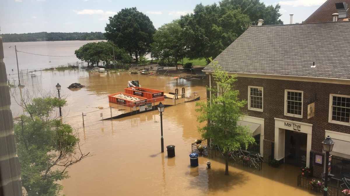
Under the DC Healthcare Facility Evacuation Plan, WMATA is listed as a partner that is tasked with providing transportation for vulnerable populations. WMATA is also a major component in the fairly novel all-city walkout evacuation plan prepared for DDOT that theorizes the impacts of an on-foot evacuation. Buses under this plan would assist those who have difficulty walking as part of a total evacuation by picking them up and dropping them at several locations outside city boundaries.
Similarly, Montgomery County's emergency management plan has multiple levels of government coordinate to keep the Maryland Department of Transportation and WMATA working together to provide transportation for residents.
In Prince George's County, at least 10% of residents in the Bladensburg area (Census tracts 8040.02, 8046, and 8063) ride transit. As GGWash has previously reported, Prince George’s bus system, TheBus, needs a little work — certainly not something you want to hear during an emergency, if you can hear anything from them at all.
Regardless, while emergency plans help, there is more we can do to protect vulnerable communities if and when the next big natural disaster strikes.
What you should do in a dangerous weather situation
With different plans of action across the region, figuring out what to do when a massive storm is bearing down can be daunting. What should residents and visitors do?
First, finding information about your current locality is the most important thing. Whether you’re at work, home, school, or anywhere else, the emergency management service for that locale is the relevant clearinghouse for information.
Second, for general tips on preparing for storms, the federal government’s Ready.gov website is a great resource.
Finally, remain connected to public information. Ensure you have access to not only classic means of news such as TV and radio, but also verified digital sources, such as the official social media feeds of weather networks, local news stations, and professional meteorologists. In the DC Metro area, thePost’s @CapitalWeather provides warning and analysis of current threats.
Be alert, be prepared, and be safe.
