Ellicott City flooded again. Was this a man-made or natural disaster?

Screenshot from a Baltimore Magazine video of flooding in Ellicott City over Memorial Day weekend of 2018. Image by Baltimore Magazine licensed under Creative Commons.
All eyes are on stormwater management in Howard County following Memorial Day weekend's stunning images of floods rampaging through historic Ellicott City, Maryland for the second time in two years. The gravity was compounded by the tragic loss of Sargeant Eddison Hermond, a National Guardsman who drowned while trying to help rescue a local business owner. Why are these floods happening, and can anything be done about it?
What causes floods?
Obviously, water, but for the purposes of discussing infrastructure and planning it's helpful to distinguish three different kinds of flooding: from overwhelmed made-made drainage systems, from high tides, and from hurricane winds.
Man-made drainage systems can get overwhelmed during a storm. When these systems reach capacity, they can surge at the input points unless there are exit points (called overflows) to prevent that. In DC, where the storm sewer system is combined with the waste water system serving part of the city, that would mean a mix of rain and sewage backing up into people’s homes.
To prevent that, the combined sewer has overflows into Rock Creek, the Potomac, and the Anacostia at various locations — and that’s why District residents now have to pay an impervious surface fee on their water bills. The EPA told the city to stop dumping sewage into surface waterways during storms, and part of DC Water’s solution is a very expensive underground tunnel to temporarily store overflow.
The Combined Sewer Overflow (CSO) watershed in DC. Image by Screenshot from DC Atlas Plus.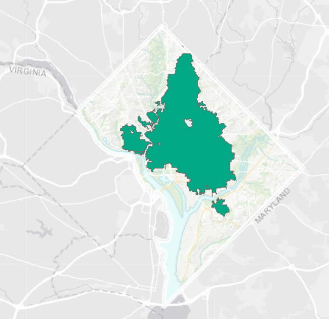
However, even the natural drainage systems around us can get overwhelmed during big storms or multiple storms. Old Town Alexandria flooded on Tuesday, June 5 because the Potomac broke its banks. The Potomac is a tidal water body, and so the surge caused by high tide was a contributing factor.
Flooding in Old Town Alexandria on June 5, 2018. Image by Rita Abou Samra.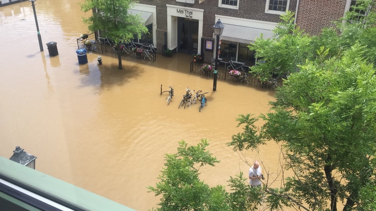
Surges can also be caused by hurricane winds, like what happened in New York City during Superstorm Sandy. Hurricanes also come with a tremendous amount of precipitation, so they can overwhelm man-made drainage systems (as with Hurricane Katrina in New Orleans) and overwhelm man-made and natural drainage systems (as with Hurricane Harvey in Houston).
The recent floods in Ellicott City were caused by both man-made and natural drainage systems being overwhelmed. Ellicott City has a long history of flooding, which makes sense given its topography. It is a historic mill town that was built to take advantage of the high-volume, fast-moving water.
However, historically most Ellicott City floods have been caused by surges from the Patapsco River, not by overflows and backups from the Tiber Branch uphill. If this is a new flood pattern in Ellicott City, what has changed?
Can we anticipate flooding?
When Ellicott City flooded in 2016, meteorologists said it was a “1 in 1,000-years-storm.” Using historical weather data, it’s possible to calculate the probability of different rainfall quantities. The actual quantity of precipitation that composes a “1 in 1,000-years-storm” will vary from region to region, but different thresholds are used by engineers and policy makers to do everything from pricing flood insurance to designing stormwater infrastructure.
The severity of storm that a particular piece of infrastructure is capable of handling is set within a regulatory context that includes the federal Clean Water Act and state and local stormwater management standards. All of these decisions are based on historical weather patterns.
But what if the weather today, or in the future, is not like the weather of the past? While members of Congress may still be taking to the floor to litigate climate change, Jason Elliott, a meteorologist with the National Weather Service, says that “The Mid-Atlantic and Northeast corridors are in general experiencing more frequent and heavier rainfall.” Meteorologist Dan Satterfield noted a recent paper in Geophysical Research Letters that concluded “atmospheric rivers of moisture are getting wetter, stronger and longer.”
It’s literally raining more. So that’s one thing that’s changed for Ellicott City — the climate.
How do we plan for flood resilience? The Five “R's”
In the aftermath of Sandy while developing the Fourth Regional Plan for New York, the Regional Plan Association articulated “five R’s” to plan for flood resilience:
- Rebuilding to better, safer standards. For example, put your beach house up on stilts!
- Resisting flood waters through engineered solutions. Think DC’s big tunnel.
- Retaining storm and flood waters through green infrastructure. In other words, don’t let the rain into the drainage system to begin with.
- Restoring and enhancing protective and productive natural systems. This can mean anything from preserving open space to engineering wetlands.
- Retreating from the floodplain. This is the hardest one to talk about, but New York, New Jersey, and Connecticut all tried it after Sandy.
You can also think of these five R’s in the inverse. While water is literally what causes flooding, this list summarizes choices we make about the built environment that exacerbate flood damage.
(Sub)urbanization in Howard County
Destroying protective natural systems can make flooding worse, especially if you do it with impervious surfaces and don’t retain the stormwater runoff with green infrastructure. This is what happened to Ellicott City, asserts Brian Kelm in an Envision Frederick County post.
“Developers, the Howard County Zoning Board, and our elected officials have planned and implemented the replacement of much of the forest and other open space with medium- and high-density housing, and the roads and other impervious surfaces that go with it,” Kelm argues. “This unprecedented “top down” flooding is not the work of Mother Nature. This is primarily a man-made disaster.”
Damage from the 2016 flood in Ellicott City, MD. Image by Preservation Maryland licensed under Creative Commons.
Let’s unpack that. It’s true that Howard County is the fastest growing county in Maryland by residential population, and new development has occurred recently in the forests uphill from historic Ellicott City. It is an immutable law that replacing pervious forests with impervious pavement and roofs will increase stormwater runoff. Were these developments badly designed?
It could be. However, according to the Chesapeake Bay Foundation, “Maryland regulations represent the state-of-the-art for stormwater policy in the United States.” Kelm specifically calls out “medium and high density housing,” even though these forms use fewer road-miles and square feet of roofing per capita.
The problem, then, is not so much the urban form, but its location in the Ellicott City watershed. Concentrating new population growth in outlying counties like Howard and Frederick instead of in established urban centers served by existing infrastructure is changing the spatial pattern of stormwater runoff and exacerbating peak flows in these once-stable watersheds.
In my (Tracy's) 2012 dissertation, I used various computer simulation techniques to model the water quality outcomes of two long-range plans for Mecklenburg County in North Carolina. While it was a lot of work to demonstrate the obvious (increased development of any form increases stormwater runoff volumes), I also found that these alternatives represented real choices about where to locate growth and potentially maximize the efficiency of engineered and natural solutions to stormwater management.
In other words, if it’s hard for DC to raise the funds for a stormwater tunnel, how on earth could Ellicott City?
How do we pay for flood adaptation?
Maryland clean water advocates have been working for years to address stormwater runoff, the only source of Chesapeake Bay pollution that continues to increase. The state eventually settled on assessing fees based on amount of impervious surface and using funds generated for stormwater retrofits. Thousands of US jurisdictions, including the District, use a version of this model.
However, the design storm for many of these kinds of retrofits is small, usually ranging from 1- to 10-year likelihood events. The Howard County Council did raise these standards in 2017, requiring 100-year control in the Tiber Branch Watershed that includes Ellicott City and updating the rainfall rate for that standard. However, retrofitting the development that has occurred in this watershed costs real money.
In light of Chesapeake Bay cleanup goals, in 2012 the General Assembly proactively addressed the funding problem with the Watershed Protection and Restoration Act, covering 10 Maryland jurisdictions (including Howard County) subject to Clean Water Act permits known as Phase I MS4s (Municipal Separate Storm Sewer System).
The current iteration of Maryland MS4 permits require counties to address 20% of existing impervious acreage every five-year permit cycle. The impervious surface fees were to apply to these 10 counties, who could choose how to structure their programs but were required to assess a fee and base it on amount of impervious surface.
In 2013, counties successfully pushed back the goal posts with the Maryland Department of the Environment right as the impervious surface fee programs were required to be finalized. This was mostly led by developer interests and their allies in county government. That's also when the phrase “rain tax” surfaced to describe these policy changes in Maryland.
The issue returned to the state legislature in 2014, due in no small part to the “rain tax” opposition efforts of Senator Allan Kittleman, now Howard County Executive. While advocates successfully resisted attempts to repeal the program, Governor Larry Hogan made repeal a major campaign promise.
The Maryland General Assembly adjusted the program in 2015, adding a rigorous financial assurance documentation by counties to prove that they have sufficient funds to adequately address stormwater management. In exchange, they gave Hogan a nominal win by removing the requirement to charge an impervious surface fee. In Howard County, now-County Executive Kittleman spent 2016 continuing to oppose the polluted runoff fee program, but was stymied by his county council.
Did Hogan and Kittleman “cause” flooding in Ellicott City? Of course not. However, there has been a lot of irresponsible rhetoric around stormwater management in Maryland that has made it politically difficult to take stormwater management seriously and begin making the needed retrofits. While Hogan and Kittleman are technically correct that impervious surface fees are not the only way to fund stormwater management, it is the most logical way to do so. The size of the remediation fee can be linked to the size of the impervious surface that generates the polluted runoff.
Impervious surface fees are clearly not a rain tax, as they are not charged on the basis of precipitation. By creating a dedicated fund it prevents stormwater from competing for general fund dollars with schools, police, and fire departments. History has shown stormwater management gets short shrift in that kind of competition. In the meantime, bringing the five R’s to Ellicott City will cost $35 million in the near term, and $60 - $85 million in the long term.
What's next?
Watch for this as a campaign issue in the Maryland governor’s race this summer. If the Democratic challenger to Hogan is Prince George’s County Executive Rushern Baker, who founded his county’s Department of the Environment, this is a clear policy difference between the two leaders. Unbelievably, Hogan is trying to run on the rain tax again. The image below is from his personal Facebook page, posted after the most recent flooding in Ellicott City.
Maryland Governor Larry Hogan chose to share this on Facebook the same weekend as the recent Ellicott City flood. Screenshot of Larry Hogan’s Facebook page by the author.
In the 2018 legislative session, Delegate Robert Flanagan, who represents Ellicott City, tried to pass legislation to peg stormwater management for historic districts to 100-year storm quantity. This bill did not pass in the Senate (it ended on the second reading). Flanagan’s other bill would have opened the watershed improvement plans required by the Clean Water Act, whose implementation is funded by impervious surface fees, to managing water quantity in historic districts. After this second devastation of Ellicott City, Flanagan may return to committee with these ideas.
Engineering solutions and higher development standards can address some contributing factors to the Ellicott City floods. At the end of the day, however, the 2016 and 2018 floods were caused by 1,000-year storm events that cannot be engineered around. It is possible to spend millions on stormwater management in the Tiber Branch watershed only to watch Ellicott City flood again. The city's topographic position in the context of global climate change is a precarious one.
*Author’s note: Thank you to Emily Ranson of Clean Water Action for a recent history lesson on water issues in the Maryland legislature.