Here’s the primer you need to understand Prince George’s extraordinary diversity
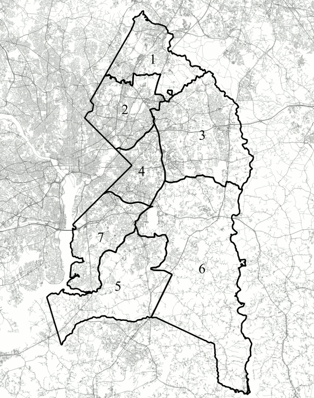
A map of M-NCPPC's seven planning subregions of Prince George's County Image by the author.
Compared to the rest of the Washington region, Prince George’s County has unique and oft-misunderstood demographics. This breakdown of the county’s mix of density, wealth, race, language, and government will help you understand it better.
Density and wealth
A good place to start when comparing the different regions is population densities and built environments. Unsurprisingly, Subregions 2 and 4 have the highest median population densities in the county — 8,200 people per square mile and 6,000 people per square mile respectively — given that they are both nearly entirely inside the Beltway.
These areas and Subregion 1 — at 4,600 people per square mile — are the only ones above the county’s median density of 4,200 people per square mile. While areas of Prince George’s County outside the Beltway are generally less dense than those of Montgomery and Fairfax Counties, the three counties have similar levels of inside-the-Beltway density.
| Planning Subregion | Land Area | Population | Median Population Density | Median Household Income |
| Subregion 1 | 45 sq. mi. | 92,000 | 4,600 people / sq. mi. | $76,000 |
| Subregion 2 | 47 sq. mi. | 256,000 | 8,200 people / sq. mi. | $60,000 |
| Subregion 3 | 85 sq. mi. | 160,000 | 3,000 people / sq. mi. | $102,000 |
| Subregion 4 | 29 sq. mi. | 124,000 | 6,000 people / sq. mi. | $60,000 |
| Subregion 5 | 72 sq. mi. | 62,000 | 1,700 people / sq. mi. | $109,000 |
| Subregion 6 | 161 sq. mi. | 69,000 | 900 people / sq. mi. | $102,000 |
| Subregion 7 | 45 sq. mi. | 129,000 | 3,500 people / sq. mi. | $72,000 |
| County Overall | 483 sq. mi. | 893,000 | 4,200 people / sq. mi. | $76,000 |
The very high density of Subregion 2 — comparable to the population density of Montgomery County inside the Beltway — is partly due to this region’s history as early streetcar and railroad suburbs. Hyattsville developed in the late Nineteenth Century around a station on the B&O Railroad, now the MARC Camden Line. College Park, Berwyn Heights, Riverdale Park, East Riverdale, Edmonston, Bladensburg, North Brentwood, Brentwood, and Mount Rainier were served by the Washington, Berwyn, and Laurel and the Washington, Spa Spring, and Gretta streetcar lines.
Several communities in Subregion 1 — Beltsville and Laurel in particular — developed around the B&O Railroad and the Washington, Berwyn, and Laurel streetcar. However, much of this area remained rural until the later part of the Twentieth Century, well after car-dependent, low-density construction had become the norm.
DC streetcars did not enter Subregion 4 except for one line that terminated in Seat Pleasant. The denser communities along Southern Avenue were served by buses from an early date, and the current route of Martin Luther King, Jr. Highway was originally the Washington, Baltimore, and Annapolis interurban line.
A map of population density by Census block group in Prince George's County, based on 2016 ACS data. Image by the author.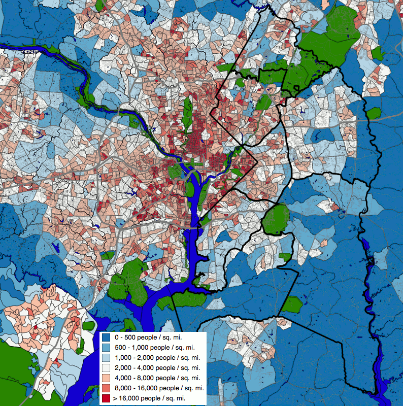
Although most dense areas of Prince George’s County are concentrated inside the Beltway, there are a few pockets of density outside it as well. Laurel, which started out as a railroad town, is the most prominent of these. Lanham-Seabrook, just east of the northern portion of the Beltway, started out as a railway suburb along the Pennsylvania Railroad (now the MARC Penn Line) and is fairly dense.
The older farming communities of Surratsville-Clinton and Upper Marlboro also have small pockets of density in their historic downtowns. Prince George’s has significantly fewer such towns than Montgomery County, though, likely due to its history as a plantation economy that was originally laid out along navigable waterways.
More recently, the northern portion of Bowie (built as a Levittown in the 1960s) and the Largo area (which was largely developed in the last 20 years) were built for cars, but are denser than other parts of the county.
A map of median household income by Census block group in Prince George's County, based on 2016 ACS data. Image by the author.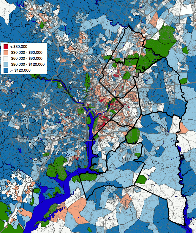
Like density, wealth varies significantly between different parts of Prince George’s County. The county as a whole is poorer than much of the region, but some areas of it are unquestionably wealthy. Subregions 3, 5, and 6 have median household incomes of $100,000 to $110,000 annually, putting them firmly in the upper middle class. Portions of these regions, in particular the Woodmore area west of Bowie, have median incomes in excess of $120,000.
Inside the Beltway, Prince George’s is noticeably poorer than other parts of the region, except for DC east of the Capitol. However, it is not uniformly poor. The median household income in both Subregions 2 and 4 is $60,000 annually, but they have significant pockets with higher and lower incomes than this. The town of University Park, along US-1, even has a median household income above $120,000.
Somewhat more surprising to me, at least, was that there is a cluster of Census tracts in Laurel and South Laurel with median incomes between $30,000 and $60,000 annually. These areas presumably contribute to bringing the median income in Subregion 1 down to $76,000 annually despite the richer communities west of I-95.
Subregion 7’s median income is even lower at $72,000 annually, primarily due to low incomes in the Forest Heights and Silver Hill areas inside the Beltway. Outside the Beltway, its median income is closer to $90,000 annually.
What about race?
If there is one reason that Prince George’s County is known nationally, it is for being a large, relatively well-off, majority-African-American suburban county. Despite its current demographics, the county was majority-white in the early Twentieth Century, and many of its earlier suburbs, including Mount Rainier, Brentwood, Hyattsville, and Greenbelt, were originally all-white communities. In the second half of the century, a combination of African American migration out of the District and white flight gave the county an African-American majority.
Graphs of race in each planning subregion and the county as a whole, based on 2016 ACS data. Image by the author.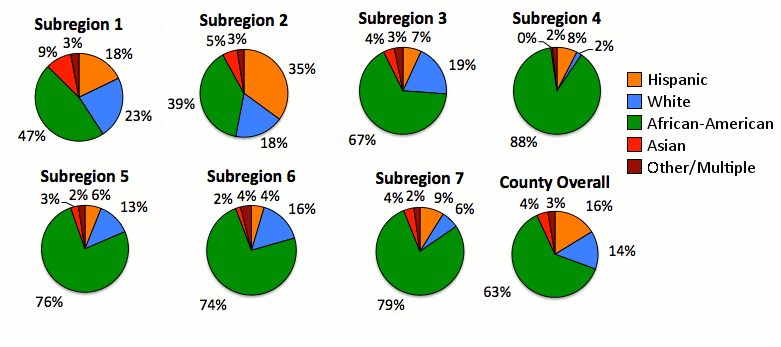
Today, Prince George’s County’s population is 63% African-American, 16% Hispanic, and 14% white. However, there is a steep north-south divide in the racial breakdown of different parts of the county. Subregion 4, the area inside the Beltway between US-50 and Suitland Parkway, is 88% African-American, 8% Hispanic, and only 2% white.
The three other subregions south of Central Avenue are also heavily African-American, with 76% to 79% of their populations identifying themselves as such on the Census. Subregion 3, containing Largo and Bowie, has the balance closest to the county as a whole: 67% African-American, 19% white, and 7% Hispanic.
However, Subregion 3’s racial balance is not evenly distributed throughout the subregion. Every Census tract in Largo is over 80% African-American, while nearly every Census tract in the portion of Bowie north of US-50 is less than 40% African-American.
Subregions 1 and 2 have a fairly different racial makeup than the areas south of US-50: both are plurality but not majority African-American: 47% in Subregion 1 and 39% in Subregion 2. Subregion 1 has the county’s largest white (23%) and Asian (9%) populations, while coming in second place in terms of Hispanic population (18% compared to the 35% in Subregion 2, which rivals that region’s African-American population.
A map of the percentage of the population identifying as African-American by Census block group in Prince George's County, based on 2016 ACS data. Image by the author.
Looking at a map the African-American populations of Census tracts in Prince George’s County makes it clear just how marked the county’s racial divide is. Census tracts northwest of the Baltimore-Washington Parkway mostly have non-African-American majorities, while, with the exception of northern Bowie, almost all of the county south of the Parkway is majority or close-to-majority African-American.
Language spoken at home
Prince George’s is mostly known for being home to a large, suburban African-American population, but the county also has a large immigrant population, at least in the north.
While the southern, heavily African-American subregions have populations of between 93% (Subregion 4) and 88% (Subregion 7) of their populations using only English at home, the northern three subregions have larger populations that use other languages, bringing the county as a whole’s average down to just under 80%.
| Planning Subregion | % English-Only Households | % Spanish-Speaking Households | % Other-Language Households |
| Subregion 1 | 68 % | 12 % | 20 % |
| Subregion 2 | 62 % | 21 % | 13 % |
| Subregion 3 | 82 % | 6 % | 13 % |
| Subregion 4 | 93 % | 4 % | 4 % |
| Subregion 5 | 91 % | 4 % | 5 % |
| Subregion 6 | 90 % | 4 % | 6 % |
| Subregion 7 | 88 % | 6 % | 6 % |
| County Overall | 79 % | 13 % | 8 % |
Subregion 3, with 82% English-only households is the closest to the county’s average, though its percentages of Spanish-speaking and neither-English-nor-Spanish-speaking households are reversed. Six percent of households in Region 3 speak Spanish at home and 13% speak a language that is neither Spanish nor English, while in the county as a whole, 13% of households speak Spanish at home and 8% speak a third language.
While Subregion 1 has the largest fraction — 20% — of households that speak a language besides English and Spanish at home, Subregions 2 and 3 also have fractions above 10%.
What is most noticeable is that 21% of households in Subregion 2 speak Spanish at home. This is not entirely surprising, given that the subregion is 35% Hispanic.
A map of the percentage of households where English is not the only language spoken by Census block group in Prince George's County, based on 2016 ACS data. Image by the author.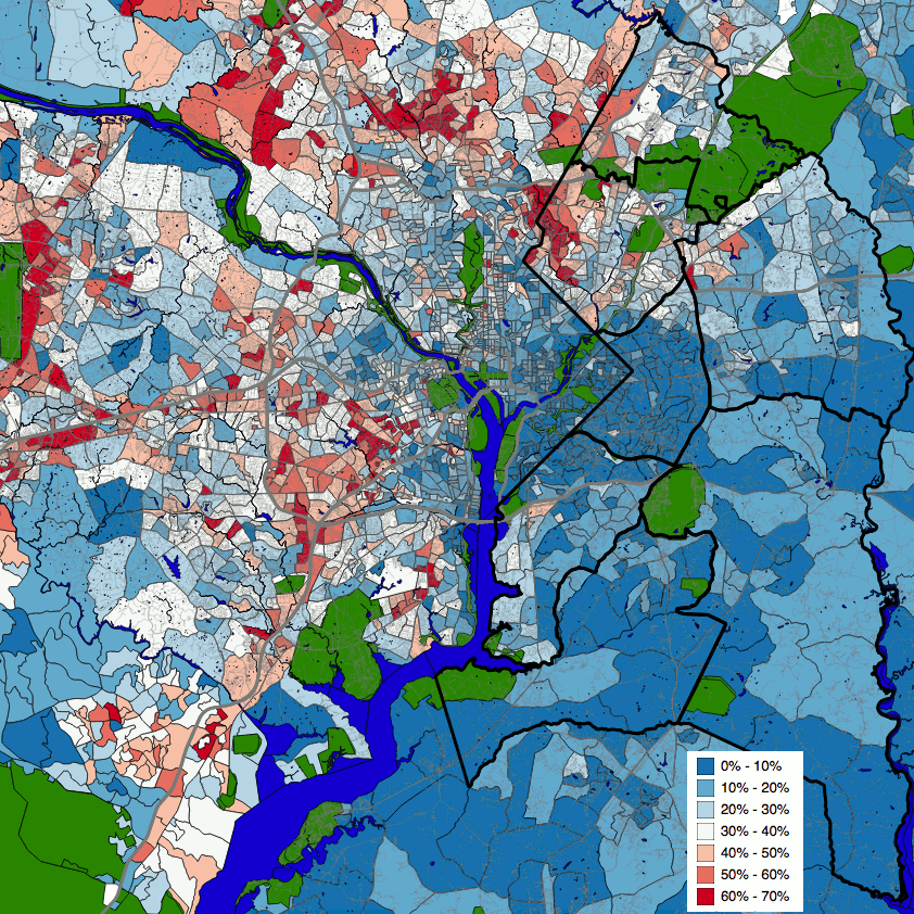
Looking at a map of Census tracts colored based on the fraction of their households that speak a language other than English at home, it becomes clear that Region 2’s large Spanish-speaking population is mainly located in a belt running from Western Hyattsville and Chillum to Langley Park and Adelphi, and into Montgomery County.
Census tracts with significant populations that speak languages other than English are primarily concentrated in the far northwest of the county along the Montgomery County border, although there is also a significant band along Kennilworth Road.
Municipal government
While it’s not really a demographic variance, there is a very stark difference in the importance of municipal governments between different regions of the county. While most of the land in Prince George’s County is unincorporated and — like in every other county in the state — the majority of the population lives in unincorporated areas, the 26% of the county’s population that does live in cities and towns is almost entirely concentrated in the northern half of the county.
Subregion 5 contains no municipalities at all, while Subregion 6 has about 1% of its population in the colonial tobacco port of Upper Marlboro and the town of Eagle Harbor at the southwest tip of the county. Likewise, Subregion 7 has 3% of its population in two suburbs inside the Beltway: Morningside and Forest Heights.
Subregion 4, which is entirely inside the Beltway, has five small municipalities: Seat Pleasant, Fairmount Heights, District Heights, Capitol Heights, and Glenarden, though the last of these crosses the Beltway to incorporate parts of Subregion 3, and 18% of its population lives in municipalities.
Subregions 1 and 3 both have a quarter to a third of their populations in cities, in both cases does to a single large city. In Subregion 3, nearly all of the 34% of the population who live in municipalities live in the City of Bowie, the county’s largest, while all of the 27% of the population of Subregion 1 who live in municipalities lives in the City Laurel, the the city’s third largest after College Park. Although most of these regions’ population lives in unincorporated areas, the dominance of these large cities leads many people to refer to the whole regions by the cities’ names, sometimes without realizing that the areas they are talking about are unincorporated.
Just as with demographics, Subregion 2 is relatively unique in terms of local government. A string of a dozen cities and towns contain nearly all the land in the corridor along US-1 and Kennilworth Avenue. Between these and a few more car-oriented suburbs in the southeast portion of the subregion, a full 50% of the subregion’s population lives in incorporated areas. No single city really dominates this area, but the four cities with populations over 10,000 — College Park, Greenbelt, Hyattsville, and New Carrollton — between them have 33% of the subregion’s population.
Of the half of Subregion 2’s population who do not live in incorporated areas, roughly half live in the strip of the subregion just along the Montgomery County border. In 1956, there was a push to incorporate this area, which now consists of Chillum, Langley Heights, and Adelphi, as a City of Chillum, which would have been the second-largest in the state.
Prince George’s Board of Commissioners strongly opposed this move, and no new municipalities have been incorporated in the county since 1953. That’s when state law changed to require the consent of county governments for new cities and towns to be formed in their territory.
What do these maps show us?
Simply looking at demographics cannot tell us what the “natural” regions of a county are, and certainly cannot tell us what to call them. History and the transportation network have a significant role to play in determining what areas are more connected to each other. However, looking at the demographics of Prince George’s County gives a picture of a county with stark divides.
In terms of race and ethnicity, it seems fairly clear that US-50 is the most significant dividing line in the county: south of it, nearly everywhere is majority African-American, often overwhelmingly so. North of this line, there are some majority African-American communities, but also many majority-Hispanic communities, some where the majority of households do not speak English at home. There are even, contrary to stereotypes, a few majority non-Hispanic white communities, such as the towns of University Park and Berwyn Heights.
Economics paint a different picture. The southern and eastern tier of the county, outside the Beltway and south of the B-W Parkway, is reasonably well-off, with middle-class and upper-middle-class communities. The area inside the Beltway is more mixed, with both middle-class and impoverished communities. However, it has almost none of the firmly upper-middle-class populations that populate most of the areas inside the Beltway in Montgomery County and Virginia.
In terms of economics, and to a lesser extent race, Subregion 1 seems to be a special case. It is the most heavily white section of the county, and has a significantly smaller Hispanic population than Subregion 2. Outside of Laurel, it is also significantly richer than Subregion 2, although the area in and to the southeast of City of Laurel are relatively poor.
Do you notice any other interesting patterns in this data?