Rail in the region used to be far more robust. Here are all the railroads we had in 1921.
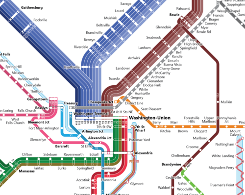
Image by the author.
At the recent Vision Zero summit, some participants pointed out that many people today never knew about the robust transit systems of the past, and thus have trouble picturing what they could look like today. We decided to republish this post about rail systems in the region, which was originally posted on February 24, 2016.
In 1921, you could take the train from downtown DC to Annapolis, from Baltimore to Harrisburg, or Winchester to DC. I built a subway-style map of the rail service our region once had.
In the Mid-Atlantic region, hundreds of trains and ferries used to serve passengers at more than 1,370 stations. However, they were run by dozens of individual companies, meaning there was no single unified system map to let people know how to get from A to B. Passengers had to pore over dozens of often-opaque timetables to know how to get around.
Doing that was no simple task, as I can now attest to after having trawled hundreds of these tables in The Official Guide of the Railways to pull together this one map.
Subway-style maps were a genius invention of the early 20th Century. By combining old railway maps with service schedules, they allow travelers to understand at a glance how the transit system works without relying on byzantine schedules.
To view a bigger version of the image, click here. Image by the author.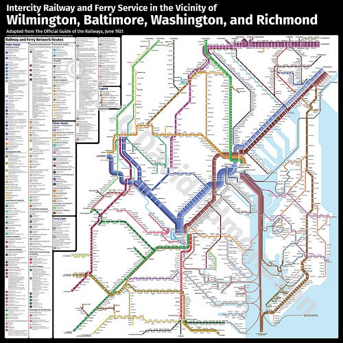
This map says a lot about how the region worked back then
My Mid-Atlantic map shows about 29,000 square miles, centered on DC and Baltimore. I tried to map to the logical endpoints of the railroads, where they converge before diverging again.
Baltimore’s prominence as a major transportation hub is clear, especially for waterborne travel. Ferries hit remote villages and towns along rivers up and down the Chesapeake, delivering people and goods between the villages or back to the dozens of railroads serving Baltimore. Though it’s tough to imagine the Rappahannock or Piankatank as transport corridors today, steamer service was often a lifeline to the rest of the country.
And while the city itself is absent from this map, you can see Philadelphia’s strong influence in the northeastern corner. The Baltimore & Ohio’s Main Line to Washington, the Pennsylvania Railroad’s Main Line along the top of the map, and Pennsy’s Washington lines all point to that formidable hub.
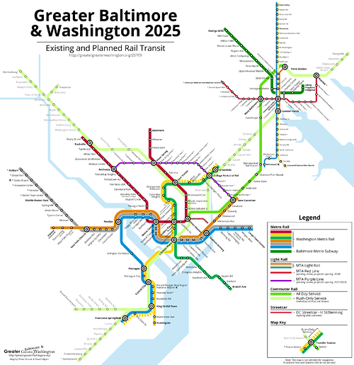
Clear, too, is the shape of our contemporary rail infrastructure in the old system. MARC and VRE both make use of old passenger routes, while Metro and Baltimore’s light rail both make use of abandoned rights-of-way.
There are also some particularly evocative and historical station names. One wonders about Tuxedo, just outside DC, or Screamerville on the PF&P. Buck Run and Doe Run are adjacent stops on Pennsy’s Pomeroy Branch. Baltimore’s Penn Station was once optimistically named Union Station, though since city’s eight stations made it hard to centralize everything, the name never took off.
This is hardly a complete transit map, of course. Because it is almost impossible to find contemporaneous timetables for every company, I had to limit myself to the companies and stations appearing in The Official Guide. Hence, the jarring absence of Silver Spring from the B&O and the lack of the streetcar line from DC to Glen Echo.
What kind of system could we have today?
Beyond just being fun for train buffs, I hope this kind of map will inspire transit advocates to think big about what we might have again one day.
Some months ago, a caller to the Kojo Nnamdi Show was hopeful that Winchester might someday get commuter rail service. It actually turns out the B&O ran through Winchester as well as a number of small West Virginia towns before hitting the main line to Union Station. Maybe that would be a good place to expand MARC’s Brunswick Line.
Or perhaps, if Baltimore again becomes the kind of major metropolitan center it once was, it would make sense to reactivate the Old Main Line between Baltimore and Frederick. Or, maybe it wouldn’t! The point is to think big, to see where nostalgia and practicality might align.
That in mind, what line do you wish would see a revival?