A bold California bill would ease transit oriented development. How would a similar approach affect DC?
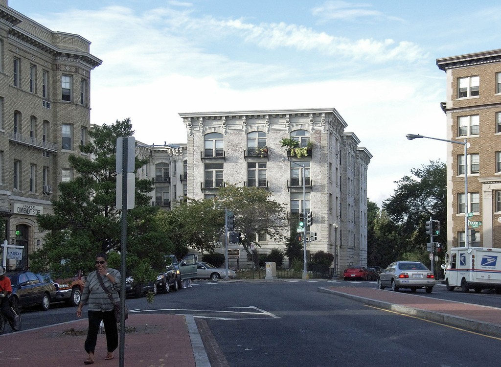
SB 827 would make it possible to build small apartment buildings, like these in Mount Pleasant, across large areas that are currently restricted to single-family houses. Image by the author.
A bill recently introduced into the California legislature boldly proposes that every transit corridor in the state be rezoned to permit mid-rise apartments. In Slate, Henry Grabar writes that it's “just about the most radical attack on California’s [housing] affordability crisis you could imagine.” In the Boston Globe, Dante Ramos writes “the bill may be the biggest environmental boon, the best job creator, and the greatest strike against inequality that anyone’s proposed in the United States in decades.”
A similar approach would have a profound impact if it were applied to DC, where many areas near transit are restricted to very low densities by zoning.
In introducing California's Senate Bill 827, city-councilman-turned-state senator Scott Wiener calls it “a strong step toward denser housing near transit and a more sustainable development patterns.” It would require that zoning rules along transit corridors “have no density maximums (such as single family home mandates), no parking minimums, and a minimum height limit of between 45 and 85 feet.”
Wiener points out that the state has made huge investments in public services within these corridors — especially along heavy rail lines that cost billions of dollars to construct, operate, and maintain — and has a vested interest in allowing the maximum number of people to be able to benefit from those investments.
The bill has sparked lively public debate.
If the bill passes, mid-rise buildings like these in Oakland's Fruitvale neighborhood could be the norm, rather than the exception, along California transit lines. Image by the author.
The bill would affect much of California's urban and suburban areas
The current text of SB 827 (which, like all bills, is subject to change) would set height limits to a minimum of 55-85 feet closest to transit (within a quarter mile, or a five-minute walk, of service that runs every 15 minutes or better), and to heights of 45-55 feet in areas a bit further from transit (within half a mile of rail stations and other hubs). As in DC, building height limits would vary based on the width of the street.
These rules would apply to very large parts of urban and even suburban California, as a preliminary interactive map by programmer Sasha Aickin shows. Most of San Francisco’s land area seems to fall within those boundaries.
SB 827 would affect large parts of the Bay Area. Image by Sasha Aickin used with permission.
The Policy Club, a Los Angeles-based group, has created a more detailed map which shows how the bill would change height, parking, and density standards within that city.
What impact would similar legislation have in DC?
As Ramos writes in the Boston Globe, “California's housing problems are like ours, but only more so. Population growth there has been far faster, and many of the land-use laws there are stricter. As a result, housing prices out there have spiraled much farther out of control.” Although he was writing about Boston, he’s also describing the housing situation throughout the Eastern Seaboard — including here in Greater Washington. (Luckily, DC has built about twice as many new housing units over the past few years than San Francisco, even though both DC and SF are each adding about 1,000 residents a month.)
So how would an idea like SB 827 impact the District?
Much of the District's land area meets the transit service levels specified in SB 827. Image by District Department of Transportation.![]()
This map, from the District Department of Transportation's benchmarking site, shows that relatively frequent transit reaches most of the District — particularly within the L'Enfant city, but also throughout outlying areas. The map highlights areas that meet the same transit access standard that SB 827 uses: within a five-minute walk of frequent local bus service, or a ten-minute walk of heavy rail. (Thanks to Ryan Westrom for pointing me to the map.)
In sharp contrast to the wide, mile-wide corridors shown on the transit access map, the District's zoning map shows much narrower strips (less than 1/10 mile wide) of multifamily zoning in most of Northwest and Northeast, limited only to land immediately fronting former radial streetcar routes like Connecticut and Rhode Island avenues.
An overview map of DC's zoning districts. Image by DC Office of Zoning.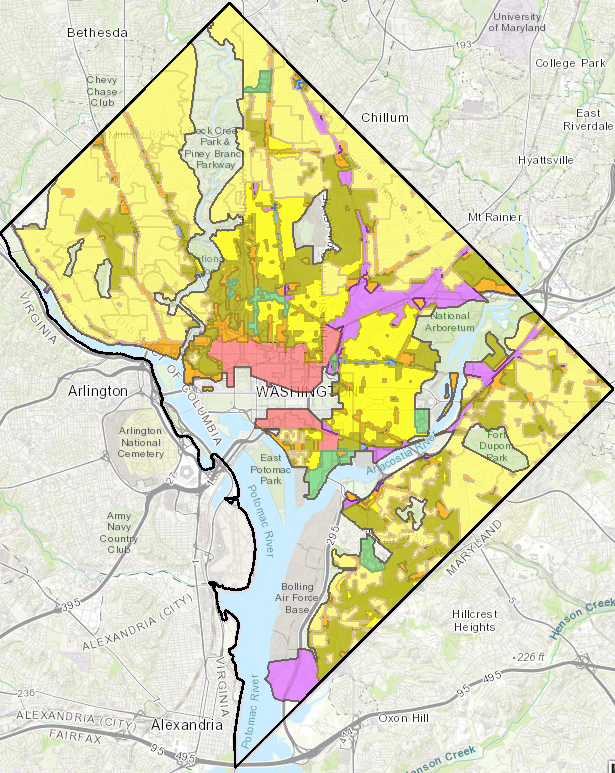
All of the yellow areas on this map have zoning that's far more restrictive than what's envisioned for transit corridors under SB 827. The pale yellow areas on the zoning map are restricted to single-family detached houses, and the darker yellow areas are restricted to rowhouses below 35 feet tall.
Many of the recent battles over development in the District would have been avoided had a similar policy been in place here. The battle over “pop-ups” resulted in allowable heights in the rowhouse neighborhoods being lowered from 40 feet to 35 feet — rather than allowing Mount Pleasant-scale buildings. The Hine School development across from the Eastern Market Metro faced almost ten years of litigation, largely because of its height. Under SB 827's standards, it could have been built years ago, as it would have been allowed 85 feet of height as a matter of course.
Multiplying transit access, without raising taxes
In a follow-up article, Wiener writes that “Restricting transit-rich areas to low-density housing has several negative impacts. First, it significantly limits how many people can easily use transit and thus drive less. By severely limiting who can live near transit, we push people farther away, force them to drive, create crushing commutes, and reduce transit ridership, all of which undermine our transit investments.”
Greater Washington suffers from much the same problem. Just nine percent of our 2,091,301 households live within a ten-minute walk of Metro. This lack of transit-accessible housing, and the resulting high prices, push even many transit-dependent residents to live far from frequent transit routes. Adding more homes near existing lines would improve transit access without adding new lines, maximizing existing transit assets.
California's ambitious goal to cut greenhouse gas pollution by 80 percent by 2050 also obligate it to vastly increase the number of residents who can easily access transit. Wiener points out that “the only way we will meet our climate and air quality goals is to build a lot more housing and to do so in urbanized areas accessible to public transportation.”
Our region has an even more ambitious set of carbon pollution goals, and so must act even more quickly to ensure compliance. Both DC and Montgomery County have pledged to cut their carbon dioxide emissions even faster than California has (all the way to “net zero” by 2050), and that all of the region's counties have signed on to a regional plan that mirrors California's goal.
Other places have laws that override local zoning
Many other places allow higher authorities to overrule local zoning rules when they're found to be too restrictive, relative to higher-level plans or laws. These often take the form of special case-by-case legal appeal processes, rather than rewriting the rules as SB 827 proposes. (Granted, all states have zoning enabling legislation that sets standards for how municipalities can zone, but few set minimum standards for zoning.)
SB 827 echoes a recent proposal by Sadiq Khan, the new Labour mayor of London, who has indicated that a forthcoming citywide plan update would flip existing planning priorities: the need for housing production would henceforth override “community character” when evaluating development proposals within transit corridors.
As with SB 827, the proposal would increase allowable building heights in many areas within half a mile of transit to four stories from two, and has attracted controversy. Robert Booth writes in The Guardian that “Conservatives at City Hall immediately accused him of 'declaring war on the suburbs' with a plan that would leave outer boroughs 'browner, overcrowded and harder to get around.'”
In London, as in DC, new growth is steered towards high-rise clusters like Battersea. Image by the author.
(Much like the current DC Comprehensive Plan, the current London Plan steers growth into high-density, master-planned “opportunity” and “intensification” areas, while maintaining existing “community character” in most of the city. This approach has come under fire, as the resulting high-rise residences are often priced far out of reach of most residents.)
The Canadian province of Ontario is in the midst of overhauling its process where local land use decisions can be appealed to the province via a “local planning appeals tribunal.” The former process frequently permitted proposals which had been rejected by local officials as being too dense.
Perhaps the best-known state law in the US that promotes housing production by overriding local zoning is Massachusetts' Chapter 40B. Under 40B, a development that includes affordable housing can circumvent some zoning rules. A recent bill before the Massachusetts assembly would, like SB 827, require all towns to zone some minimum area for multifamily zoning, but not very extensively. (In suburban Boston, some towns do not permit any new multifamily development.) Some others states' courts have required every town to zone for at least some multifamily or low-income housing.