These maps answer the question “Where is that place in Maryland, anyway?”
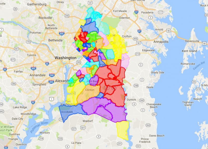
Image by the author.
Many places in Maryland aren't a “town” or “city” in the traditional sense: they don't have a local government or strict, official boundaries. To help people mentally define these places, I made these maps of Montgomery and Prince George's counties.
In most of the United States, populated places are set up as a town or city, with a mayor, a local government, and defined boundaries, and any places that aren't are usually rural. That's not the case in Maryland, where most places are unincorporated, and local government happens at the county level. Some unincorporated places may still have thousands of residents: Germantown, the largest “city” in Maryland after Baltimore, has over 100,000 people.
In those cases, there are usually a couple of other ways that communities are defined. The US Postal Service assigns every place a zip code, with at least one acceptable “city” name attached. And the US Census Bureau creates its own boundaries, called a Census Designated Place (CDP), if it determines the place is populated and used by local residents in daily communication (rather than as a name solely for planning or other purposes). The CDP's boundaries are mapped based on the geographic extent associated with inhabitants' regular use of the named place.
The result of having so many different and conflicting boundaries is that it can be hard to say where a place actually is. Residents of a given community might strongly identify with that place, but may disagree with each other as to where it actually is, or even what it's called.
This summer, I read a great post by D.W. Rowlands discussing why places around the DC area are difficult to pinpoint, which includes a map of area communities as they're defined by the US Census Bureau. My maps attempt to find a middle ground between the census bureau, postal service, and municipal boundaries (where they exist). I am hoping these maps can at least further the conversation about where different communities begin and end. At the least, they fill in gaps on D.W.'s maps (rhyme unintended). Note that the boundaries I drew, to the extent possible, align with parcels and physical features. For example, if a zip code splits a property, I typically ensured that the property was either completely inside or outside of the zip code, depending on the property's postal address.
My map of Prince George's County. Image by the author.
Prince George’s County is the second-most populous county in Maryland, with a lot of established communities particularly near the Capital Beltway. There are a good number of incorporated places with formal boundaries (27 in total), but they are relatively small in area with respect to the size of the county, and can be dwarfed by the unincorporated land around them. A prime example of this is Upper Marlboro, which is just 0.43 square miles in size, but a large swath of the county is able to use the Upper Marlboro mailing address.
In addition, the postal service sometimes ignores incorporated communities for simplicity. For example, the towns of Cheverly, Edmonston, Landover Hills, and University Park often contain a Hyattsville address. The town of Forest Heights uses an Oxon Hill address, and the town of Morningside uses a Suitland address.
Here, I look to define the boundaries of communities prominent enough to use for the postal address. This obviously means defining communities that show up as a postal address. But I also look to define communities embedded within the Hyattsville and Upper Marlboro postal areas, that are Census Designated Places.
I used parcel addresses shown on Google Maps to draw boundaries for the unincorporated communities in the county. However, for the postal areas of Hyattsville and Upper Marlboro, I relied a lot on census-designated place boundaries to draw the lines. Physical features were used to fill in gaps and inconsistencies.
My map of Montgomery County. Image by the author.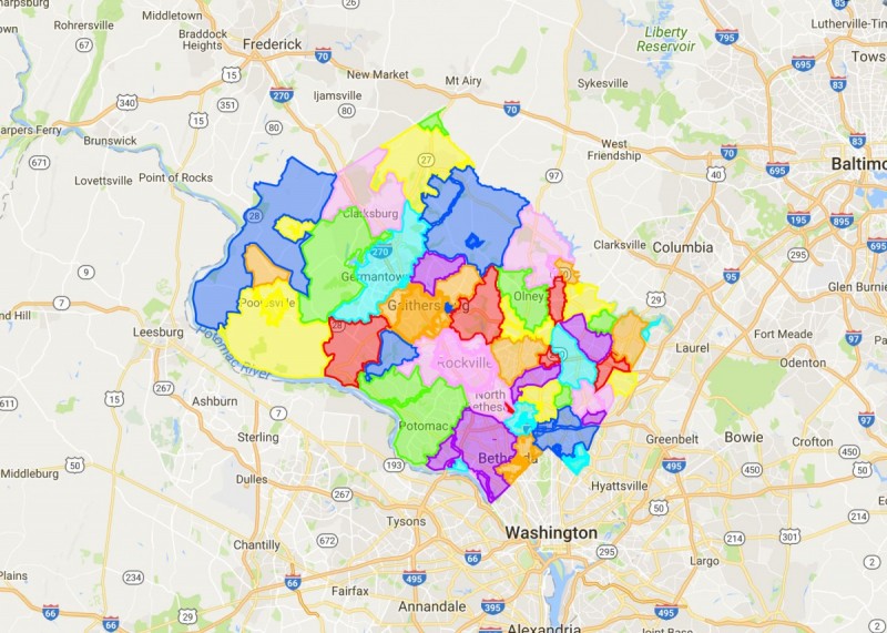
Montgomery County is the most populous county in Maryland with a lot of established communities. Yet there are few formal boundaries; the county acts as the main municipality and keeps most of its area unincorporated. The county does have about 20 incorporated places, but many of those are small in area.
For simplicity, the postal service often merges unincorporated places into incorporated ones, but this can warp one’s sense of place. For example, incorporated Gaithersburg has an area of 11.5 square miles, and my map has it covering 20.7 square miles. But the postal area of Gaithersburg includes 77.8 square miles.
Here, I look to define the boundaries of communities prominent enough to use for the postal address. This obviously means defining communities that show up as a postal address. But I also look to define communities embedded within Gaithersburg, Rockville, and Silver Spring that are Census Designated Places.
In fact, even communities recognized by the postal service aren’t always recognized by the Census if they lack population. There are 4 communities in Montgomery County that show up as a postal address but are not a CDP: Beallsville, Boyds, Brinklow, and Dickerson.
I used parcel addresses shown on Google Maps to draw boundaries for the unincorporated communities in the county. However, for communities within the postal areas of Gaithersburg, Rockville, and Silver Spring, I relied heavily on census-designated places to draw the lines. Physical features and civic associations were used to fill in gaps and inconsistencies.
The western border of the county extends across the Potomac River, but I used the C&O Canal as a boundary to avoid complications with islands in the river. There are 2 places mapped that are not a postal address or a CDP, Norbeck and Woodfield. Norbeck is a community recognized by residents and shows up in many place names south of Olney. Woodfield is used as an alternate name to the western part of Laytonsville. It has a Laytonsville zip code but physically ties in more with Damascus.
Calverton, Dickerson, Laurel, and Mount Airy have boundaries that extend beyond Montgomery County. I only drew the complete boundaries for Calverton and Dickerson. Laurel and Mount Airy are centered outside the county; I wanted to keep the focus on the county.
What do you think? Do these boundaries make sense to you? What would you change?