Here’s what a freeway through Mount Pleasant and Tenleytown would have looked like

I-70S would have demolished blocks of Mount Pleasant. Image by Michael Baker/NCPC.
Can you imagine a highway trench in Mount Pleasant? Or an interchange at 14th & U? That was the vision planners had for DC in 1959, and had they realized it, I-70 South would have cut through the hearts of some of DC's busiest neighborhoods.
In the 1950s, officials were eager to make the nation’s capital model of city planning. City planners were rewriting its zoning code, and a novel public-private urban renewal scheme was remaking near Southwest. And highway planners were busy crafting a scheme for a net of freeways they thought would speed travel in and out of the city.
One of those roads was the Northwest Freeway. It went by a few names: I-70S and US-240 were the official ones. Outside the beltway, it was eventually labeled I-270. In 1959, the plan was for the highway to enter DC at Friendship Heights along Wisconsin Avenue, cross Rock Creek Park, and run down 14th Street to intersect with an inner loop beltway around DC's central business district, all part of a huge network of highways through existing neighborhoods.
Here's a sketch of the freeway as it was planned:
I-70 S wasn't the only route planned, but the National Capital Planning Commission took a special interest in it. In order to understand the costs, the agency commissioned a civil engineer, Michael Baker and Associates, to design the road's ramps, bridges, and buffers.
Overlaying pen drawings on aerial photographs, Michael Baker and Associates produced these drawings, revealing what the highway would have done to DC.
Because the NCPC commissioned these drawings, they only cover the route in DC. But the highway would have come out of the 270-495 exchange, running along Wisconsin Avenue on the east side through Bethesda. This would have made it a buffer for Chevy Chase until it switched sides in what was then a largely undeveloped Friendship Heights. Had this happened, Downtown Bethesda as we know it likely wouldn't exist.
The freeway would have bridged Rock Creek. North is at top right. Image by Michael Baker/NCPC.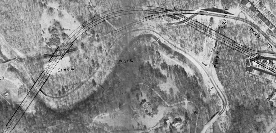
The Northwest Freeway was one piece of a re-imagined city
Coordinating the District's overhaul was Harland Bartholomew, the chairman of NCPC and an authority to a generation of planners. He seems to have personally pushed for the highway to follow this route. Planners of his generation believed that single family homes were the hearts of neighborhoods, so they designed I-70S to run around expanses of “stable” single family houses, and instead through parkland and “blighted” commercial strips. They figured residents would drive to the stores anyway, so it made sense to give drivers and not pedestrians the leafy route.
This would have been 14th & U. North is at top. Image by Michael Baker/NCPC.
Bartholomew and the author of DC's 1958 Zoning Code, Harold Lewis, knew freeways had big impacts. I-70S fed into an inner loop beltway which Lewis described as a “dam” that would contain downtown. So, even though Bartholomew used parks and tunnels to be sensitive to houses west of Rock Creek, planners wanted to plow I-70S and the inner loop through “obsolete” rowhouse neighborhoods east of the park and the most important (but 'obsolete”) black commercial strip, U Street.
The business establishment, including newspapers like the Washington Post, supported Bartholomew and Lewis's plans. DC's Board of Trade saw disposable income moving into the suburbs, and thought the highways would keep downtown alive. Whether they really bought into academic ideas like blight or urban renewal, they saw these highways as a way to keep the District afloat.
The Tenleytown Trench. North is at top. Image by Michael Baker/NCPC.
I-70 S never happened because residents fought against it
But the design horrified far more people. A number of homeowner groups rose up to stop projects like the Northwest Freeway. Using lawsuits, hearings, and political influence, the group delayed the highway for five years. Supporters, including Bartholomew, accused the opponents of being NIMBYs unconcerned about other areas. Certainly some were only concerned with their home prices, and leaders of the predominantly black neighborhoods facing other highways at first felt a lack of solidarity.
But the middle of the Civil Rights movement, Bartholomew’s accusations of selfishness backfired: the highly motivated activists joined a citywide coalition to stop all of the highways and build the Metro system. This period is often called the “freeway revolt.” Planners took most of the roads off the map, starting with I-70S. Urban renewal efforts shifted from slum clearance to rehabilitation.
One particularly effective opponent was Peter Craig, a well connected Cleveland Park lawyer, who amassed a collection of planning documents, now housed at George Washington University. That is where I found these maps, as well as a wealth of other historical planning information. It is available to to the public by appointment, subject to a lot of rules.
Here's the complete route:
Note: The images have heavily yellowed and the ink had faded. I have adjusted them for legibility on screen.
Section from Friendship Heights to Fort Reno. North at top right. Image by Michael Baker/NCPC.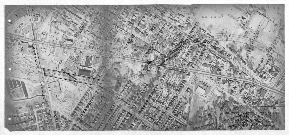
NCPC imagined the highway entering DC west of the commercial area Friendship Heights. The 1950 Comprehensive Plan and the 1958 zoning code assigned that as large commercial hub, but little had been built at the time. The highway would then make an S-curve over Wisconsin Avenue, through the neighborhood, over Fessenden Street and turn back south in Fort Reno Park.
Section from Fort Reno to Archibald Glover Parkway. North is at top right. Image by Michael Baker/NCPC.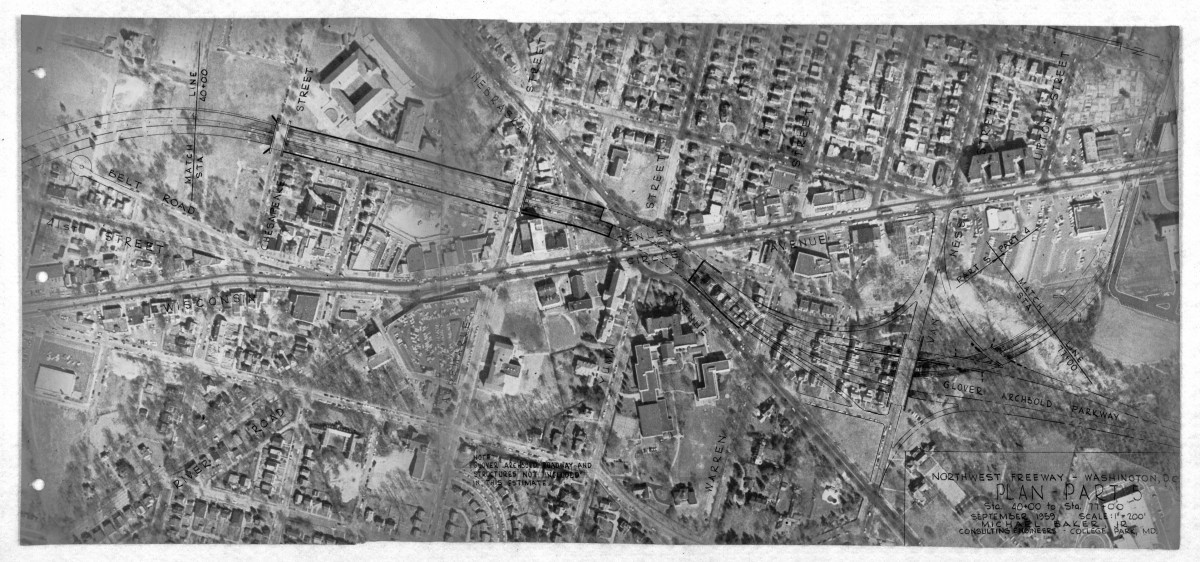
In Fort Reno Park, the highway would have passed through what are now athletic fields into a trench at the double roadway in front of Wilson High School. Michael Baker and Associates imagined the trench would be softened with trees and benches. Picture the E Street Expressway in Foggy Bottom, a completed section of the same highway plan.
The road would have gone under Tenley Circle and split into two routes at a large interchange at Van Ness Street. One would head due south along a Glover-Archibold Parkway, connecting to I-66. The other, the trunk of I-70 S, would have turned east again, just north of what's now the Fannie Mae building.
Section from Archibald Glover to Reno Road. North is at top. Image by Michael Baker/NCPC.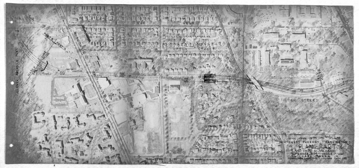
The road would have entered a tunnel underneath Tilden Street, between the Sidwell Friends School and the Washington Home. It then would have popped out at Reno Road and skirted the southern edge of the National Bureau of Standards, now the International Center embassy complex.
Section from Reno Road to Rock Creek. North is at top right. Image by Michael Baker/NCPC.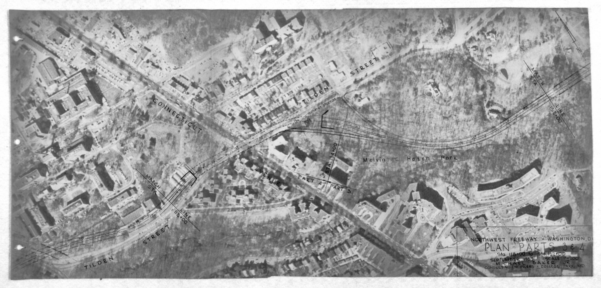
I-70 S would have entered another long tunnel beneath Connecticut Avenue and re-emerged in the wooded valley of Melvin Hazen Park. It would have run behind the Czech Embassy, relatively discreetly, similar to the New York Avenue freeway.
Sensitivity to runoff was not a concern at all. Bartholomew was a civil engineer by training and often compared highways to sewers, describing them as a similar engineering problem: moving large volumes at high speeds.
Section from Rock Creek Klingle Road. North is at top right. Image by Michael Baker/NCPC.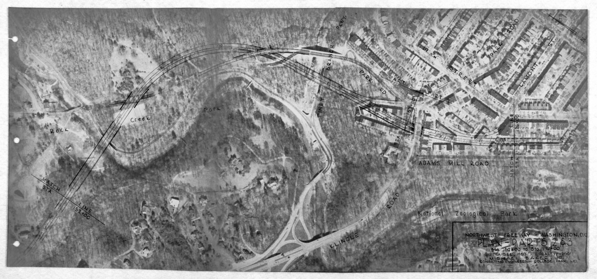
The proposed route crossed Rock Creek south of Pierce Mill and wove over and under Park Road. It crossed Piney Branch, clipped a few blocks of houses, and ran at grade alongside Adams Mill Road. This would likely have looked similar to the at-grade sections of the Anacostia Freeway.
Section from Mount Pleasant to Columbia Heights. North is at top. Image by Michael Baker/NCPC.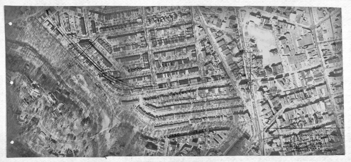
In one of the more destructive segments, the road turned along Irving Street, still at grade, ran under Mount Pleasant, and then arced to 14th Street, avoiding Meridian Hill Park. Where the road curved to cross Irving Street is now the west end of the DC USA shopping center in Columbia Heights.
Segment along 14th Street. North is at right. Image by Michael Baker/NCPC.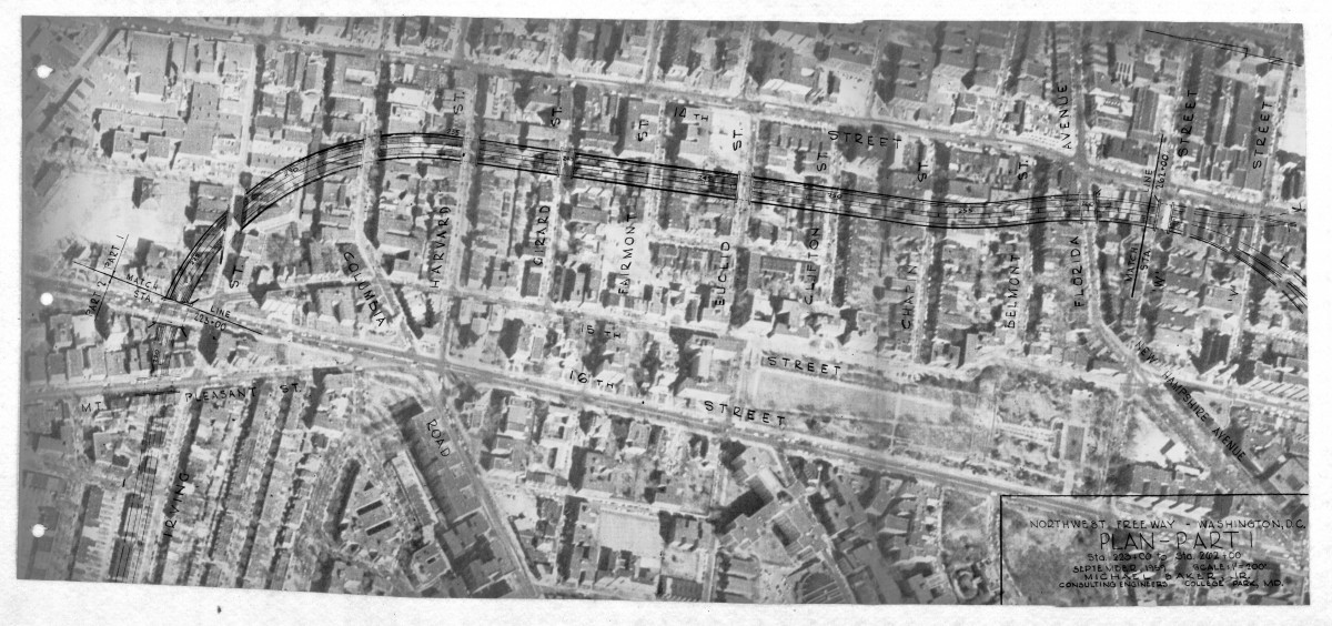
The report highlights this section through as challenging. The steep climb anyone who’s biked up 15th Street knows was a problem for trucks, so the engineers considered designs with both truck passing lanes and without.
Section from Florida Ave to the U Street interchange. North is at top. Image by Michael Baker/NCPC.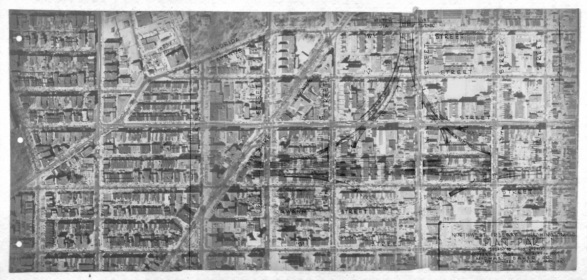
Finally, the planners intended to tie the roadway into the “Inner Loop” Highway with a looping interchange, obliterating the intersection at 14th and U. At the time this plan was made, that road would have run from the end of I-66 at K Street, through Dupont Circle, Adams Morgan, along the north side of U Street, and eventually to what is now I-395.
One portion of this plan that was built was the intersection between where I-66 turns onto the Roosevelt Bridge. Originally, this was to be an interchange similar to the one on U Street, with a branch of the Inner Loop heading south, tunneled next to the Lincoln Memorial and around the Tidal Basin.
I see in this design a what an effort to limit the impact building a highway through urban neighborhoods looks like. It shows there is no way to do that.