Fort Totten streets get a little closer to complete
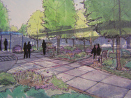
Proposed plaza outside Fort Totten station. Courtesy Toole Design.
Last night, Toole Design Group presented alternatives for the redesign of 1st Place and Galloway Street NE near the Fort Totten Metro station.
The alternatives significantly improve walking and bicycling throughout an area that is today suburban and difficult to traverse. In particular, Riggs Road at 1st Place will include pedestrian refuges, a section of the Metropolitan Branch Trail will be built, 3rd Street will be opened to pedestrians until the roadway is completed in the future and both the station’s Kiss and Ride and bus bays will be redesigned pending WMATA review to better accommodate pedestrians.
Despite these improvements, the National Park Service remains uninterested in working with the neighborhood to improve well-established dirt paths worn by pedestrians accessing Metro from the surrounding area.
The Metropolitan Branch Trail would receive a boost from this project in the form of a 14 foot wide sidepath planned for the west side of 1st Place. A narrower sidepath is planned for the south side of Galloway Street as part of the Prince George’s County Connector trail.
Toole’s alternatives propose bike lockers outside the main station entrance, although exactly what type of bicycle storage is provided would be left up to WMATA. Since Fort Totten will be the nexus of both rail lines and a trail system, perhaps WMATA should think bigger than the standard bike lockers and include a weather-protected bike cage instead.
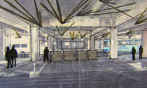
Proposed bike lockers at Fort Totten station. Courtesy Toole Design.
The news for other paths, however, is not as bright. Residents accessing the Metro who live south of Gallatin Street often cut across National Park Service land between Galloway and Gallatin streets. The result is a well-worn dirt footpath that remains unlit. A Park Service representative at the meeting stated that “NPS is very concerned about cut-throughs… [and is] not proposing any formalization of that path.”
Because these specific path improvements were not included in the General Management Plan for Rock Creek Park or the Management Plan for Fort Circle Park, NPS claims it does not have the resources or the mandate to work with DDOT to improve conditions for neighbors. The plan for Rock Creek Park, of which Fort Totten is a part, was rewritten last year. A new version of the Fort Circle Park plan was adopted in 2004.
These problem is that these plans are rewritten only every few decades. For example, the last version of the Fort Circle Park Management Plan was from 1968. NPS representatives at last night’s meeting claimed that until the plans are rewritten around the year 2040, there will be no improvements. “We’re concerned,” the representative said, “about a slippery slope where you formalize one [path] and then you formalize another,” thereby “reducing green space.”
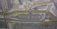
Alternative for the area near the station. Courtesy Toole Design.
With or without NPS, Toole staff will soon develop a preferred alternative for the street right-of-way, which they will bring to 30 percent design. Final design will begin once funding is secured. The project is seeking stimulus dollars, which would accelerate its timeline, though construction is not likely to begin until 2011.
Although this seems far away, the preferred alternative will be developed soon and public input is key. Last night’s agenda explains the alternatives in some detail; Toole also has a community mapping site available where the public can plot existing problem zones.
Along with the inclusion of crosswalks on all four sides of a redesigned intersection of Riggs Road and South Dakota Avenue, the progress of this plan indicates a brighter future for pedestrians in Fort Totten.
Disclosure: As noted in my author biography, I work for Rails-to-Trails Conservancy, which does work to promote the Metropolitan Branch Trail.