Here are the answers to whichWMATA week 95
On Tuesday, we featured the ninety-fifth challenge to see how well you knew the Metro system. Here are the answers. How’d you do?
This week, we got XX guesses. XX got all five correct. Great work XX!
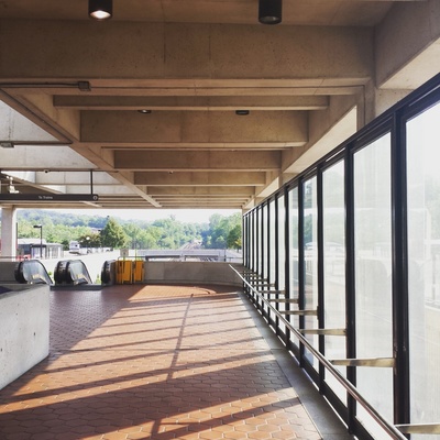
Image 1: Southern Avenue
This week was a themed week. All of the stations are located on or very close to a jurisdictional boundary shown on the Metro map.
The first image shows a view from the mezzanine at Southern Avenue, one of the four “high peak” stations in the system. This station, as its name indicates, sits on Southern Avenue, which forms the boundary between DC and Prince George’s County. The main clue here was the bus loop bridge at the far end of the platform. We featured it in week 31.
XX knew the right answer.

Image 2: Friendship Heights
The second image shows Friendship Heights from the Western Avenue mezzanine. This is one of the “arch I” stations that are located along the Red Line northwest of downtown. Friendship Heights is the only one of those stations with two mezzanines. It also has globe lights atop pylons, which are only usually used at outdoor stations.
This station sits almost entirely in the District, but the northern wall of the station is just south of the Maryland line, but two of the four entrances from the Western Avenue mezzanine lead into Montgomery County.
XX guessed correctly.

Image 3: Takoma
The third picture shows the solitary elevator faregate at Takoma station. Takoma is the only above ground Red Line station that has a platform faregate. This is because the elevator here is located a good deal farther north than the escalator entrance at the southern end of the station. So it has its own fare control.
This station sits entirely within the District of Columbia, but Montgomery County (and the city of Takoma Park) is located just across Eastern Avenue, less than a block away.
XX got it right.

Image 4: Van Dorn Street
The fourth image shows the platform at Van Dorn Street, viewed from the sidewalk along Eisenhower Avenue. The outdoor nature of the station and the “gull I” canopy limit this to one of 12 stations. Since the station isn’t elevated, you can further narrow the possibilities. But this four-lane road means it has to be Van Dorn Street, the only station that fits.
This station sits on the border between Alexandria City and Fairfax County. The station is in Fairfax County, but the road and bus loop is in Alexandria City.
XX figured it out.

Image 5: Capitol Heights
The final image shows the street elevator at Capitol Heights. There doesn’t appear to be much to go on in this image at first glance. However, with a close look, you can spot a “Welcome to DC” sign in the center. This sign welcomes people driving in on Central Avenue as they cross Southern Avenue into DC from Prince George’s County.
This station is entirely within Prince George’s County, but is just across the street from the District.
XX came to the correct conclusion.
Great work, everyone! We’ll be back in two weeks (on December 6) with another quiz.
Information about contest rules, submission guidelines, and a leaderboard is available at http://ggwash.org/whichwmata.