Inauguration every day? Metro studying bike/ped access
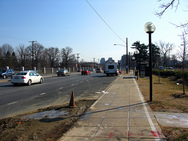
Around Medical Center Metro. Photo by thisisbossi.
Over the next 20 years, Metro ridership is expected to grow significantly (up 40% from 2005). According to Metro’s Kristen Haldeman, that will make the Inauguration Day crowds a daily experience. It’s going to be impossible to handle that kind of ridership if people try to get to the Metro stations with the same driving mode share we have today.
There aren’t enough parking spaces. Parking is about 90% full on a typical weekday, with some VA stations over 100% full, meaning that some people leave and others fill the spaces. There isn’t much land to build more parking garages, and Metro doesn’t have the money to build more garages. That’s why Metro is studying pedestrian and bicycle access to their stations. You can contribute by taking the online survey.
They’re concentrating on stations where a large portion of people driving come from very short distances, typically 3 miles or less, and figuring out what Metro or local jurisdictions can do to encourage them to walk or bike. Sometimes the solution will be fixing some sort of connectivity issue, like a nearby trail that doesn’t have an obvious or safe route to the station. Sometimes it will be just a matter of providing signs from the station to the trail or vice versa.
They’re also looking at improving bike storage at stations, with better lockers, bike cages or improved or expanded racks. They’re also looking at coordinating with Smartbike at downtown destinations so you can ride from your final station to your destination. A lot of these improvements are going to go into Metro’s 10-year capital needs inventory, and be part of the recommendations staff makes to the Board for capital funding.
The better portion of the evening was spent discussing the consultants’ station typology. They took all stations in the system and tried to find similar characteristics and an example station. Then, they will develop recommendations for those example stations and see if those recommendations are applicable to the others in the category. The categories are given in the presentation. If this method is successful it will save Metro and the consultants a fair amount of time, so it’s important that the categories and example stations be selected accurately.
A look at the categories (PDF) illustrates the wide variety in stations, from freeway-dominated Franconia-Springfield, to towering Ballston, from “campus” oriented Medical Center to suburban West Hyattsville. The consultants were especially interested in getting feedback about the categorization as well as the selection of example stations, so please take a look at that and provide it in the comments.
Metro is interested in your opinions on access to Metrorail stations by bike or foot, the survey is collecting data. I’m going to point out this article to the Metro project manager so if you leave comments here she might read them.
The project team will collect data until August, then investigate the model stations and best practices from other cities. They’ll draft recommendations and develop cost estimates until November, then an implementation strategy in January. By March, Metro expects to have a final plan to present to the community and the Board.