Help us understand route decisions on Metro
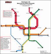
Image by Matt Johnson.
Several months ago, I created some maps showing how Metro’s proposed Blue Line reroute would affect headways and travel times. Some commenters asked how the volume of riders compared to the current and proposed headways.
In an effort to analyze these volumes, I need your help. I’m working on a project for one of my Urban Planning classes with a teammate. While we have point-to-point travel data from WMATA, that data does not include the routes people take within Metro. In many cases, there are several feasible alternatives, like transferring between Red and Green at either Fort Totten or Gallery Place.
In order to estimate this model, therefore, we are asking you to take a very short 10-question survey on your Metro preferences. Click here to take the survey. The survey is back now. - David Please only take the survey if you’re a regular Washington Metrorail rider. It would also be great if you could pass this link on to friends, family, and coworkers in the region. We will post our results here when the project is complete.