As urban center, New Carrollton faces uphill battle
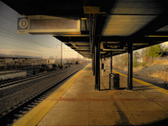
New Carrollton Amtrak/MARC platform. Photo by author.
Since 1978, the rail station at New Carrollton has been a transportation hub of increasing importance. For Prince George’s County, it’s the transit hub, hosting some 25 local bus routes, inter-city buses, Amtrak and MARC trains, and the Orange Line. Sometime early in the next decade, it will also be home to the Purple Line.
But despite these advantages, the area around the station remains woefully underutilized 3 decades later.
The State of Maryland and WMATA have high hopes for the neighborhood, though. The New York Times reported Tuesday on efforts to create a new plan for transit-oriented development on 39 acres owned by Maryland and WMATA.
By all indications, the man Metro has working on this project, Steven Goldin, is the right one for the job. He’s serious about converting underutilized WMATA property into an asset that generates both revenue and riders. But in Prince George’s County, his job won’t be easy.
The Times alludes to a few hurdles that it claims have stymied transit-oriented development at New Carrollton. They mention corruption in the county government and Prince George’s blue-collar roots among the reasons TOD hasn’t appeared around the county’s 15 Metro stops.
But in real estate, the key is location, location, location. And in that regard, New Carrollton faces an uphill battle.
Even if Metro is successful in attracting transit-oriented development to the site, the area is likely still going to fall short of becoming an urban center like Silver Spring or Ballston, mainly because the station is in the wrong place.
Like most Metro stations in Prince George’s County, New Carrollton is located off the beaten path. Here, the station is sandwiched between 2 freeways and a high-speed rail line, and has few connections to surrounding neighborhoods. No through surface streets get very close to the station, which means there’s little incentive for retail to locate there, despite ample freeway access.
This is in stark contrast to Silver Spring. The Metro station there has many similarities to New Carrollton. Both stations opened in 1978. Silver Spring is one of the largest bus hubs in the region and is also home to MARC commuter trains. And until just a few years ago, the area suffered from some of the same negative perceptions that New Carrollton faces today.
Yet Silver Spring has become a vibrant neighborhood where people live, work, and play. It’s held up as a national example of how to build a transit-friendly urban center in the suburbs.
What can account for the difference?
I think the primary difference is that when the Metro station was sited in Silver Spring in the late 1970s, Silver Spring was already a place. It already had a walkable street grid, neighborhood-serving retail, and was a nascent office node. But more importantly, it was already a hub. Two of the primary roadways serving the county — Georgia Avenue and Colesville Road — intersect just 2 blocks from the station.
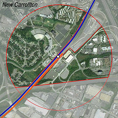
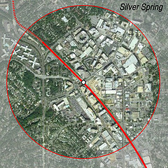
Left, half-mile radius from New Carrollton. Right, half-mile radius from Silver Spring.
In 1978, as today, Silver Spring was a place people lived in, worked in, shopped in, played in, and passed through.
Prior to the opening of the Metro station at New Carrollton in 1978, the site was vacant. It was not at a crossroads and not a neighborhood center; it was just a stand of trees next to the train tracks. If there was ever a hope of building a cohesive street grid around what would become the station site, it had been dashed years before with the construction of the Capital Beltway and Route 50.
The single-family neighborhoods in the general vicinity of the station are all separated from it by 4-lane expressways or suburban arterials. It is not possible for many people to walk to the station or to any of the TOD that might one day appear.
In Silver Spring, on the other hand, the station and the vibrant downtown are both easily accessible to pedestrians coming from most of the surrounding neighborhoods.
The Northeast Corridor essentially divides the station’s transit shed into two halves. There is no direct roadway connection between the east and west sides of the station. Pedestrians can pass through the station’s tunnel, but to get a car from the east to west entrances requires a drive of over 2 miles.
North of the station, much of the half-mile transit shed is taken up by the massive New Carrollton rail yard. This takes up a good deal of space, and further divides the two halves of the station area.
This limited circulation for both cars and pedestrians presents a severe barrier to creating a place at New Carrollton. It’s far more severe than the division caused by the Metropolitan Branch in Silver Spring, where the roads are also scaled more for an urban setting than a dragway.
Whereas there are no road crossings of the Northeast Corridor/Orange Line within the half-mile radius of New Carrollton, there are 3 within Silver Spring’s half-mile radius: Spring Street, Colesville Road, and Georgia Avenue.
That doesn’t mean that Metro and Maryland will fail at building TOD in the area, though. The infrastructure in the neighborhood can be made more pedestrian friendly. A better street grid can be created. Apartments, offices, and shops can be constructed.
But even if every acre of the site is built up with high-quality, well-designed TOD, New Carrollton probably won’t become the region’s next Silver Spring. The station’s site is simply too isolated and divided for that.
Right now, the only reason to visit the site is to park (or drop someone off) at the Metro station or one of the isolated, auto-oriented office buildings. More TOD will generate more trips, but I doubt it will reach the critical mass necessary to truly transform New Carrollton.
Despite these flaws, though, New Carrollton remains one of the best candidates for TOD in Prince George’s due to its role as a hub. But that’s only because almost all the other stations in the county are sited just as poorly.
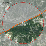
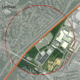
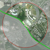
The siting of other Metro stations in Prince George’s often means half of the walkshed is
on the wrong side of a freeway. From left to right, Cheverly, Landover, and Suitland.