Is WMATA planning a Bloop-er?
Blue Line Loop proposal. Image by WMATA
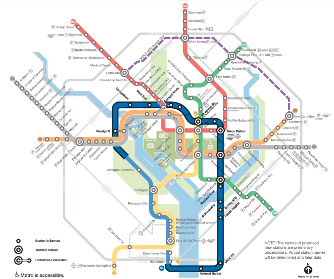
In July, WMATA unveiled the top five contenders for the transit system’s next big expansion plans, all of them aimed at fixing its capacity crunch at Rosslyn. The top-scoring option is a loop of the Blue Line – a “Bloop,” as some call it – serving M Street and Union Station before veering due south to Saint Elizabeths, Bellevue/Washington Highlands, Oxon Hill, and National Harbor before re-crossing the Potomac to meet at Huntington.
It is a sensible, albeit costly, proposal, and integrating some of the ideas Adam Bressler recently wrote about in GGWash would strengthen it further. But the process by which the Bloop was studied and identified highlights weaknesses in the region’s transit governance, inflating costs for agencies and creating headaches for riders: siloed planning on the one hand, and short-sighted planning on the other.
Siloed planning
The DC region is served by three different regional passenger rail agencies: WMATA, VRE, and MARC. Maryland’s Purple Line, running in an arc through the Maryland suburbs, will make a fourth. Together, these serve 11 different endpoints radiating out from the city; the Bloop would add a twelfth. While WMATA runs alongside both MARC and VRE for part of their distances, MARC’s three corridors separate from and then rejoin WMATA: the Brunswick Line between Silver Spring and Twinbrook; the Camden Line between Union Station and College Park; and the Penn Line between Union Station and Cheverly. Additionally, VRE provides a unique endpoint on its Manassas Line as well as a Potomac River crossing, serving trips between Crystal City and Union Station.
The central network of DC’s rail system shows three mainline rail corridors, including MARC lines through what is currently a rail desert to the northeast. WMATA’s potential new rail corridors, beyond existing rights-of-way, are in black. These are M Street through the core, the Bloop heading south to Capitol South and Navy Yard, and potentially new rights-of-way to the Northeast. Both options that go to Greenbelt nearly duplicate the Camden Line, deviating only slightly to serve Union Market in DC and Port Towns in Bladensburg. The option to extend the Silver Line to New Carrollton is more of a diversion, serving Landover Hills before joining up with the Penn Line. Image by the author. 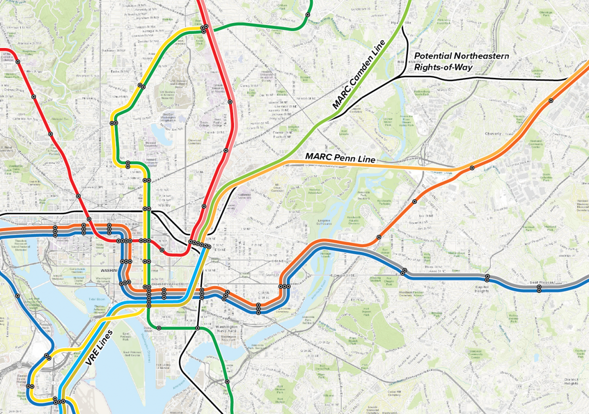
These valuable assets – unique corridors, unique endpoints – need to be considered by WMATA planners as they contemplate how to spend their $40 billion budget. Three WMATA proposals reuse MARC corridors, duplicating service while using up adjacent right-of-way that could be used to build dedicated MARC passenger tracks, separate from freight, allowing MARC to operate much better service. This has already occurred on the Brunswick Line at Silver Spring, where the Purple Line, Metropolitan Branch Trail, and WMATA tracks have used up all the space that might be used for new passenger tracks.
Rather than ignore existing railway assets, WMATA ought to consider how to better integrate them into the system. It contemplates significant bus improvements in its low-cost alternative to decongesting Rosslyn, but perhaps boosting capacity on the Long Bridge rail corridor beyond what is currently planned would have a similar effect.
It also might be cost-effective, from a ridership standpoint, to pay for upgrades to MARC and VRE along its current corridors, thereby boosting the value of WMATA’s piece of the network. It might even be cost-effective to integrate fares and improve connections between stations. Network effects mean that any additional link adds value to all other links: bringing MARC, VRE, and WMATA together as a single network would make for a powerful change.
Short-sighted planning
The single-minded focus on fixing Rosslyn means that WMATA is only thinking about the next extension. Lots of ideas thrown around over the past 15 years have been about single lines, leaving it up to advocates to consider wholesale changes to the network. Planning as a network has both strategic benefits, in that lines can be planned which complement one another; and tactical benefits, in that stations can be designed to facilitate transfers ahead of time, saving costs as the system is built out.
Transit researcher Alon Levy argues that radial subway networks are best, with straight lines going through the city center and out the other side. With straight lines, travel is direct, and future lines could easily be oriented to intersect any other line. U-shaped lines and L-shaped lines, in contrast, present topological problems, foreclosing the possibility for transfers on new lines (a new line west of 14th Street would miss the Green Line, for instance) or creating bent, and therefore slower, trips.
A topologically perfect Metro system. It’s not meant to show exactly where lines ought to go (a so-called fantasy map), but rather it helps to illustrate the general directions lines might go almost irrespective of terrain or development patterns. Image by the author. 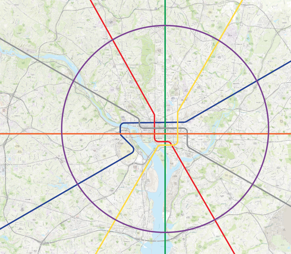
Planning one line at a time makes U- and L-shapes more tempting, but a even a relatively straight line can be made indirect and therefore provide slower, lower-ridership service. Stuart Donovan, a New Zealand transportation planning consultant, recently pointed to Auckland as a good example of this phenomenon. Jarrett Walker, an American public transit consultant, added that these indirect, squiggly lines are ones “that your grandchildren will curse you for.”
And it does seem like the Bloop is trying to squiggle its way to serve a few different destinations, hitting M Street, Union Station, Southeast DC, and National Harbor.
The results of a 2013 model showing crowding outside the downtown core developed using aspirational land-use plans from the time. Image by WMATA on PlanItMetro. 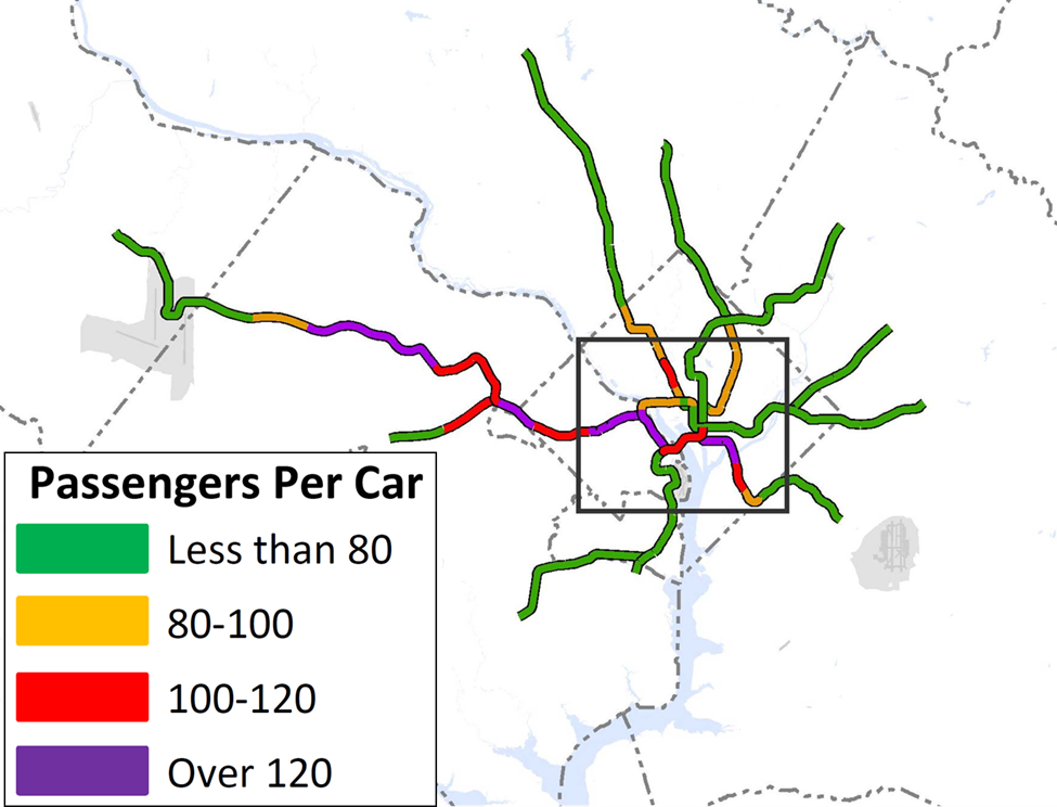
If WMATA were to plan a next-generation network – perhaps by giving every line its own tunnel through the core – it could find complementary alignments missed by a one-line-at-a-time methodology. Even if it found that the Bloop is still a good option, what stations will be needed to facilitate transfers to a separated Yellow Line? Or separated Silver? Where will the train yards need to be, and how large?
These questions will go unanswered in the current planning system. Ideally, this work would be done by the Transportation Planning Board (TPB), a regional body tasked with coordinating the region’s transportation plans.
Yet for political reasons, TPB generally functions more as a convener than a regulator. Leaders in the same jurisdiction are often divided over what projects to support at the TPB, which hinders the board’s effectiveness. Look no further than ex-Maryland Gov. Larry Hogan’s feud with Montgomery County over Beltway expansion. This dysfunction leaves WMATA itself to fill the gaps in regional transit planning.
If the Bloop is the last piece of railroad WMATA intends to ever build, then it would be a good project. It would serve some of the poorest parts of DC and Maryland whilst fixing Rosslyn, after all. But DC is unlikely to stop growing anytime soon, and by 2040 – when the Bloop would open – leaders will doubtless be clamoring for a new one.
By taking stock of the totality of the region’s rail transport network and planning for ongoing expansion, WMATA will be ahead of the curve, gifting the region with decades of new opportunity and growth that our grandchildren will thank us for. Merely looking at just this one project, and just this one system, may lead instead to their curses.