Coalition releases new Georgetown transportation alternatives for review

There could soon be more options to cross in and out of Georgetown than this lone Metrobus by Der Berzerker licensed under Creative Commons.
A coalition of business and advocacy groups and government agencies has arrived at the next phase of the Georgetown Transit Enhancement to Metrorail Study on car-free transportation options between Georgetown and Metrorail services.
The coalition, consisting of the Federal City Council, the District Department of Transportation, the Georgetown Business Improvement District, and the National Capital Planning Commission, began their study in September 2021. Earlier this month, the coalition released six alternatives for the public’s consideration and a survey soliciting public feedback on the study and next steps. The survey is open for responses until September 30, 2022.
Since its opening in 1976, Metrorail has expanded — and continues to expand — to serve 91 stations across the Washington region. Georgetown, a neighborhood with a vibrant commercial, residential, and university district is a notable exception. Without direct Metrorail access, transit users have relied on buses, rideshare services, or their own feet to get to work, school, or shops.
The study presents enhanced bus service and aerial gondola schemes narrowed down from forty initial ideas. Here’s a look at the alternatives:
Here are the bus concepts:
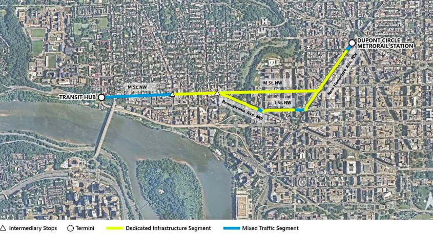
– Fast bus connection between Dupont Circle Metro and Georgetown would run along New Hampshire Ave, L Street NW, Pennsylvania Avenue, and M Street NW; Georgetown terminus would be at the former Exxon site at M Street NW and Route 29 at the Key Bridge, much of the route on dedicated lanes.
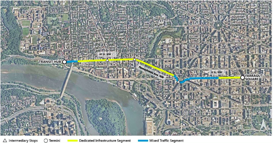
– Fast bus connection originating at Farragut Square, running along K Street NW, Pennsylvania Avenue NW, and M Street NW with stops at Washington Circle and along M Street.
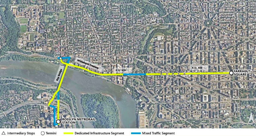
– Fast bus connection originating at Farragut Square, running along K Street NW and along the Georgetown waterfront, crossing the Key Bridge and terminating at the Rosslyn Metrorail Station.
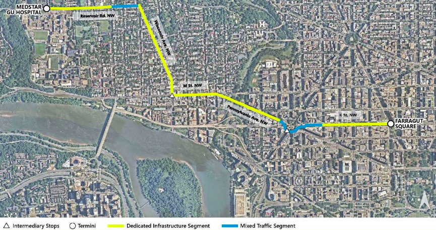
– Fast bus connection from Farragut Square to Georgetown University Medical Center, following K Street NW to Washington Circle, then Pennsylvania Avenue to M Street NW before turning on Wisconsin Avenue and Reservoir Road.
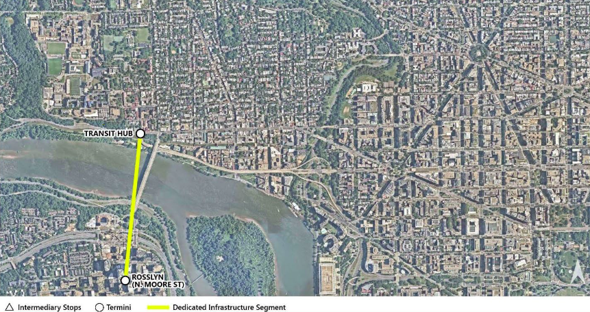
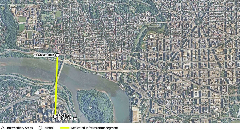
Here are the gondola concepts:
— Aerial gondola between Rosslyn and Georgetown, Rosslyn terminus at N. Moore Street.
– Aerial gondola between Rosslyn and Georgetown, Rosslyn terminus at N. Lynn Street and Georgetown terminus at the former Exxon site.
Here are the key rejected concepts:
– Water taxi service extension, due to lack of existing Metrorail stations right by the Potomac River.
– Metrorail service and infrastructure extension, however WMATA is still weighing this option.
– DC Streetcar service and infrastructure extension, as the District Department of Transportation (DDOT) has shifted its focus to the Benning Road corridor.
What happens next?
As for next steps, Greg Billing, Georgetown BID transportation director tells GGWash that the coalition would begin pursuing a National Environmental Policy Act (NEPA) compliant study looking into the project’s impact on the natural and built environment. A gondola, for example, would involve crossing state lines, a navigable body of water, National Airport’s flight path, two different national parks, and a national historic district. Billing estimates that a NEPA study would take 1-2 years and cost anywhere from $500,000 to one million. That study, as the coalition’s survey explains is the case for the whole project, has no funding sources or project sponsors at this time.
With other Metro-accessible areas of the region, such as The Wharf becoming popular with retail, entertainment and flexible office spaces, stakeholders also emphasized transit’s role in the city’s pandemic recovery.
“It’s really important[ to note] that there are no conclusions yet,” said Federal City Council Transportation and Infrastructure Director Laura Miller Brooks. “And the goal of this ten minute questionnaire that we’re promoting is to ask people what they think about our process and analysis thus far … there are a lot of really interesting elements that we’re excited for the public to engage with.”
“The Federal City Council understands that the future of our city and also certainly a strong economic recovery relies on a continued vibrant transit system,” Miller Brooks said.
Business leaders on the other side of the river are on the same page.
“With Rosslyn serving as a regional transportation hub, we believe a holistic, multimodal approach that evaluates all options is critical to supporting our long-term growth and economic development,” Rosslyn BID President Mary-Claire Burick said. Innovation in transportation is important to move a city into the future. We look forward to learning more about this planning effort and gaining insights around the impact it could have in the region.”
The next phase of planning will begin after the 30 day public comment period comes to a close on September 30 and the coalition issues a final report. You can access the questionnaire here in English and Spanish.
Disclosure: The Georgetown Business Improvement District (BID) and the Rosslyn Business Improvement District (BID) are members of the DC Sustainable Transportation Coalition, which GGWash manages; the coalition’s membership includes ten of DC’s BIDs.