Here’s a look at how zoning in Montgomery County can impact a neighborhood block by block

Looking out along Second Ave, in Woodside, a neighborhood in Montgomery County. Image by the author.
The last few months of 2020 featured quite a few developments that could help shift the dynamics in Montgomery County’s affordable housing crisis. The county council approved incentives to build high rises on WMATA property, unanimously voted to end the county’s housing moratorium, and will soon consider a measure to allow for missing middle housing close to metro stations.
Councilmember Nancy Navarro (District 4) also sponsored Bill 44-20, which passed and will require the Office of Legislative Oversight (OLO) to submit a racial equity and social justice impact statement for each Zoning Text Amendment (ZTA), a requirement that is already in place for bills. OLO expects the bill to help diminish racial and social inequities because such analysis may help mitigate further unintended consequences of zoning. A ZTA involves a change in the text of the zoning ordinance of the Montgomery County code. The Council may amend the text of the Ordinance to create new zones or delete existing ones, or more frequently to change standards governing the development and uses allowed in particular zones.
Rather than get into an in depth analysis of this bill, or any of the others the council recently took action on, the new year gives us a chance to look at some potential impacts of these changes and some of the stark differences between neighborhoods that share almost the same location, but have different zoning.
The comparisons are not meant to be comprehensive or definitive. The American Community Survey (ACS) data they use dates back to 2013, is based on sampling, and due to the size of the geographic areas data is available for, zoning changes aren’t always completely isolated from one sector to another. That said, they help paint a picture of how zoning decisions of the past have shaped racial and economic distribution in the county, and how the decisions we make now may have similar impacts going forward.
Only a few small areas of Montgomery County allow significant density
Downtown Silver Spring (DTSS) is one of the few places in the county to allow significant density, and the core is rather small and ends abruptly (possible helpful changes in the local sector plan that could allow for more missing middle housing notwithstanding). This provides a chance to look at some stark differences, sometimes literally across the street.
The sea of yellow you see on this map of downcounty is made up almost entirely of R-60, R-90, and R-200 zoning, all of which allow the construction of only single family homes. The little islands of red in Wheaton, Bethesda, and Silver Spring (zoned some form of Commercial/Residential designation) and the areas of brown you see, which are zoned R-10 (mostly apartment buildings, although detached house, duplex, and townhouse building types are allowed) are some of the few exceptions to this rule in the image below (the red by Rockville, which controls its own zoning, is White Flint, and primarily retail and office, not residential).
A view of southern Montgomery County and its zoning, from the county’s official zoning map Montgomery County Zoning (mcatlas.org) 
The other side of the street, and a world apart
By zooming in on some of the boundaries between these two zones, we can see how starkly zoning, and little else, changes the economic and racial composition of a neighborhood.
Take for example this comparison between the Northwest edge of DTSS and Woodside, which is literally across the street, and primarily single family zoned.
Woodside (Yellow Portion) and the NW Edge of Downtown Silver Spring (Red Portion) divided by Spring Street Image from Montgomery County Zoning (mcatlas.org 
By comparing a slightly expanded version of this border in the county map that contains ACS data, we can see some significant demographic differences despite the close proximity.
A grouping of three ACS block groups that together comprise several blocks of the NW edge of DTSS. Image from Region Stats (mcatlas.org) 
Much of Woodside, directly NW of the previous image. Source: Region Stats (mcatlas.org) 
As detailed in the chart below, the DTSS area is majority minority, 99% renter occupied, and has an average household income of $67,000. Looking at Woodside, with its immediate change to predominantly SFH exclusive zoning right across Spring Street, the area is majority white, has an average household income of $155,000, and is 80% owner occupied. The difference in homes making less than $40,000 and more than $150,000 is also dramatic, even though these two neighborhoods are literally across the street from one another.
Chart produced by author using ACS block group data from Region Stats (mcatlas.org) 
This is but one of dozens of such hyperlocal comparisons that could be done with county zoning and demographic data, and readers can explore these for themselves using the maps here and here, but a larger scale comparison between two very different but adjacent communities is also telling.
A larger scale, a similar picture
The first set of images below shows two Southeastern portions of DTSS, and one section of East Silver Spring running along Sligo Avenue, all of which include significant multifamily housing, though East Silver Spring has more of a mix of single family homes and apartments. Collectively this area is 24% owner occupied and 76% renter occupied, is majority minority and has an average household income of approximately $86,000 a year.
Eastern Portions of DTSS and East Silver Spring. Image from Region Stats (mcatlas.org) 
The same approximate area from the county’s zoning map Montgomery County Zoning (mcatlas.org 
Now compare it to this second set of images which is largely made up of the single family zoning dominant areas of Takoma Park, including much of the historic district, and directly borders two of the three previously highlighted zones.
ACS block groups of predominately single family home zoned sections of Takoma Park. Image from Region Stats (mcatlas.org) 
Zooming in on a section close enough to see street names, you can see that with a tiny parcel of R-40 that allows duplexes an exception, this entire area is R-60, single family homes only. (Readers can confirm consistency in the cut off areas by looking at the previously referenced maps)
A close up look at single family home zoning in Takoma Park. Image from Montgomery County Zoning (mcatlas.org 
Even though this area is within walking distance of the previous area, the demographics are markedly different. The area is 69% white, 82% owner occupied and has an average household income of $182,000 with nearly half of households having an income of $150,000 or more. These areas are close to each other, and both are at least *near* density and transit (including the Takoma station south of the image). The main difference, other than the stark divide in diversity and the income needed to live there, is zoning, and as a result, density. Once again the chart below puts this into some perspective.
Chart produced by author using ACS block group data from https://mcatlas.org/RegionStats 
Some might point to the fact that Takoma Park is a city which provides some services and governance independent of the county. This is certainly true, however, there are some areas of the city that do have a significant share of residents in apartments (though none have been built since the 1970s and they are largely on the periphery). They are visible in the red and brown sections of the first image below.
More dense zoning on the outskirts of Takoma Park. Image from Montgomery County Zoning (mcatlas.org) 
The same approximate area from the county’s region stats map. Source: Region Stats (mcatlas.org) 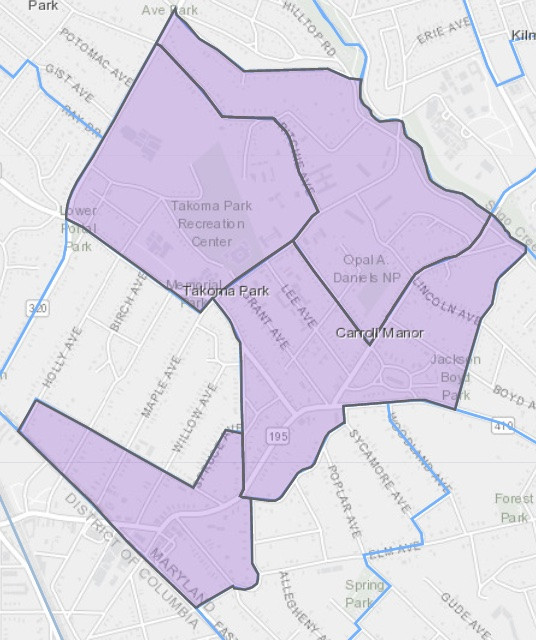
Here, the white population falls to 35%, the area is two-thirds renter occupied and the average household income falls to $75,000 with only 15% of households earning $150,000 or more a year. Same city, same government, similar location, different zoning, vastly different populations. The chart below adds in this next grouping to the previous graphic. As readers can see, it has much more in common with DTSS than it does with the rest of Takoma Park.
Chart produced by author using ACS block group data from https://mcatlas.org/RegionStats 
This is not meant to be a comprehensive analysis. More flexible zoning is not a panacea for economic and racial equality and diversity. Those questions are complex and beyond the scope of a single article, but it is clear that differences this profound, in areas that are otherwise very similar, is not a total coincidence. Only the well off can live where only a house can be built in such an expensive part of the county. Perhaps a racial impact study done in the past would have led to more flexible zoning and housing options that could have helped make this divide less deep, and maybe the actions taken and being considered by the county will allow those moves to be made better in the future. Other areas around DTSS and Wheaton see similar demographic changes along similar zoning divides. You can see for yourself on the county maps linked in this article.
The last year brought a lot of changes to Montgomery County housing policy, plus some that may still be adopted. Examples like these highlight just how important these decisions will be to make room for everyone in our county.