How do we define our region? Here are some ways to look at it.

Washington, DC seen from space in 2015 by European Space Agency licensed under Creative Commons.
Is Fredericksburg part of Greater Washington? How about Frederick? Defining our region is tricky – and a little whimsical –but here are some ways we can look at it.
City lines are blurry
Cities, ZIP Codes, and other political jurisdictions seem like natural building blocks of how we look at what forms a region — but in reality, they can be tenuous and inconsistent.
Washington, DC forms the core of our region as a major job center, the national capital, and arguably the most recognizable jurisdiction in the area. As GGWash contributor Dan Reed points out, however, the urban-suburban distinction between DC and its neighbors is fuzzy – Downtown Silver Spring, for instance, is more built up than the adjacent neighborhoods in DC.
The District of Columbia, for instance, has shrunk in area since Virginia reabsorbed Arlington and Alexandria in the 1846 Retrocession. Meanwhile, sprawling cities in Texas have often grown in physical size by annexing their suburbs.
Plan of the city of Washington and territory of Columbia, 1819 by Library of Congress, Geography and Map Division.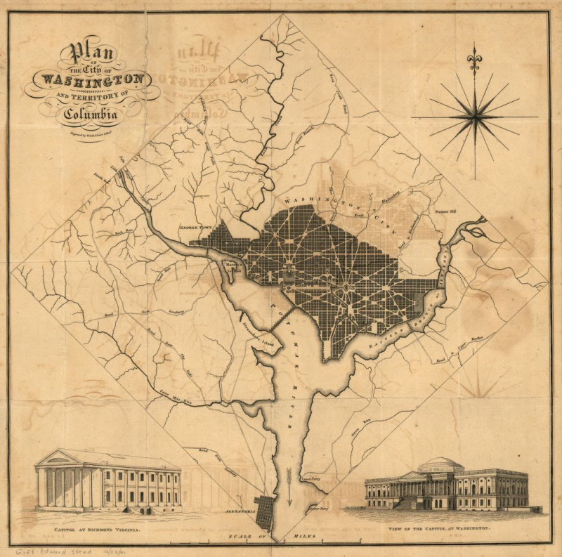
To add to the confusion, several densely developed areas in the region aren’t even technically cities – Arlington is a county, for instance, while Silver Spring is an unincorporated area with no clear political boundaries.
ZIP codes are no more helpful. As our contributor DW Rowlands wrote in 2018, ZIP codes can have multiple place names and do not necessarily correspond to political boundaries or geographic regions. While the Postal Service does assign broader regions ZIP code prefixes, the borders of those broader regions do not correspond to what most people see as the Washington region.
Accordingly, those considering the region should recognize that communities don’t end at ZIP code, city, county, or state lines.
Urban Areas and Metropolitan Statistical Areas
As GGWash Contributor Dan Malouff writes, the US Census Bureau’s ‘Urban Area’ method is a good way of measuring urban development with an apples-to-apples comparison. This method looks at urban development, rather than shaky political boundaries. Using this expanded definition, our region includes around 5 million people.
Although Urban Areas (and their smaller counterpart, ‘Urban Clusters’) are a really good way at measuring what cities are, they still are sort of exclusive when looking at a regional level. Using our earlier example, the Census Bureau counts both Frederick and Fredericksburg as their own Urban Areas. So by this measurement, these cities are not part of our region.
For an even more exclusive definition, we can look to an Office of Budget Management (OBM) measurement, the Metropolitan Statistical Area (MSA). The basic building blocks of an MSA are counties, so this measurement still runs into the problem of political boundaries, but offers a broader alternative to Urban Areas.
The Washington-Arlington-Alexandria, DC-VA-MD-WV MSA (an official title, if not one that rolls off the tongue) doesn’t just cover Frederick and Fredericksburg, but stretches as far as Jefferson County, West Virginia.
Washington-Baltimore-Arlington, DC-MD-VA-WV-PA Combined Statistical Area by US Census Bureau.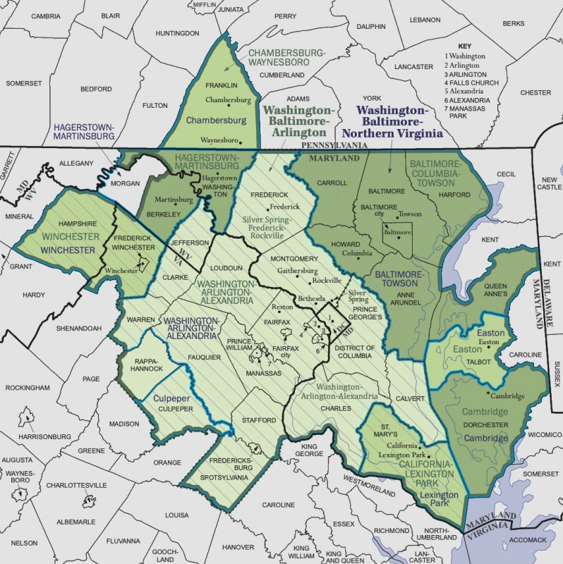
This even wider definition still has some shortcomings, however. Many residents of Howard County, Maryland, for instance, commute to Washington, DC, for instance. Conversely, many people from DC and the surrounding counties catch flights out of Baltimore-Washington International Airport, located in Anne Arundel County, Maryland. Despite the interconnectedness, both of these counties are located in the closer Baltimore–Columbia–Towson Metropolitan Statistical Area.
Recognizing the interconnectedness of nearby cities, Census has an even more inclusive measurement – the Combined Statistical Area. The Washington-Baltimore-Arlington, DC-MD-VA-WV-PA Combined Statistical Area includes the Washington, DC, Baltimore, and several smaller MSAs to form an area with more than 9 million residents – second only to Greater New York and Los Angeles in population.
Populations by different regional definitions
| Definition | Population |
|---|---|
| District of Columbia Only | 702,445 |
| “Inside the Beltway”* | 1,725,686 |
| Washington, DC-VA-MD Urbanized Area | 5,051,789 |
| Washington-Arlington-Alexandria, DC-VA-MD-WV MSA | 6,251,240 |
| Washington-Baltimore-Arlington, DC-MD-VA-WV-PA CSA | 9,800,391 |
| District of Columbia, Maryland, and Virginia Combined | 15,262,848 |
All data from the 2018 American Community Survey 1-Year Estimates, except where noted. *2013 estimate by Michael Rodriguez.
Other definitions
There are countless other ways to define the region.
With political boundaries out, some use other kinds of boundaries to mark the region. One of the most common reference phrases is “inside the Beltway.” In 2013, GGWash Contributor Michael Rodriguez looked at what “Inside the Beltway” would look like if it were a city, calculating that it would have nearly 2 million people.
Other definitions are far broader. One group, the Greater Washington Partnership, is pushing the idea of a “Capital Region” stretching from Baltimore to Richmond. Those who measure the Washington region by its commuters might determine it includes places as far away as York, Pennsylvania and Martinsburg, West Virginia.
Transit and trails in the “Capital Region” by Greater Washington Partnership used with permission.
The “DMV” has become a popular term in recent years, but even that definition depends on who you ask. Does it just cover metropolitan Washington? Baltimore? Richmond? All of Maryland and Virginia? There isn’t a consensus.
None of these measurements even touch on the harder-to-define cultural boundaries that most of us probably use when talking about what our region is – what accent you might have, what football or baseball team you watch. So whether Frederick or Fredericksburg ‘seems’ like it is part of the region depends a lot on who you are asking and why. An Urban Area might be a great way to compare the Washington, DC area to other metropolitan areas, but it probably doesn’t tell you much about commuting patterns or how people see the place where they live.
How do you define our region?