Here’s where crash fatalities and injuries are happening in Prince George’s County

Route 210 in Accokeek, Prince George’s County by Ken Lund licensed under Creative Commons.
As part of its Vision Zero Initiative, Prince George’s County published a tool in August mapping recent traffic crashes involving fatalities or serious injuries. Anyone can now explore the data to see where serious crashes are happening and where those crashes involve pedestrians or bicyclists.
The county’s data maps are part of an effort to better monitor traffic crashes to identify trends, high risk populations, and dangerous locations. The county plans to use this data to work toward Vision Zero, a goal to eliminate traffic fatalities and injuries by 2040.
A screen shot of Prince George's County's tool shows data on pedestrian fatalities 
The maps include crash data between 2015 and 2018, and include two data sets. The first set shows pedestrian-involved crashes resulting in serious injuries and fatalities. The second data set shows total fatal collisions separated by mode — motor vehicles, pedestrians, and bicycles.
The maps show that there were 350 fatal collisions overall in the county between 2015 and 2018. Of these, 251 motorists, 94 pedestrians, and five bicyclists were killed. While much of the discussion of Vision Zero relates to pedestrian and bicycle safety, because those modes are the most vulnerable to serious injuries and fatalities, achieving Vision Zero involves eliminating all traffic deaths and serious injuries for all modes. Prince George’s County, as well as other jurisdictions that have adopted Vision Zero, will need to work to address roadway traffic safety for motorists as well.
This chart shows the breakdown of traffic fatalities based on which jurisdiction maintains the roadway. 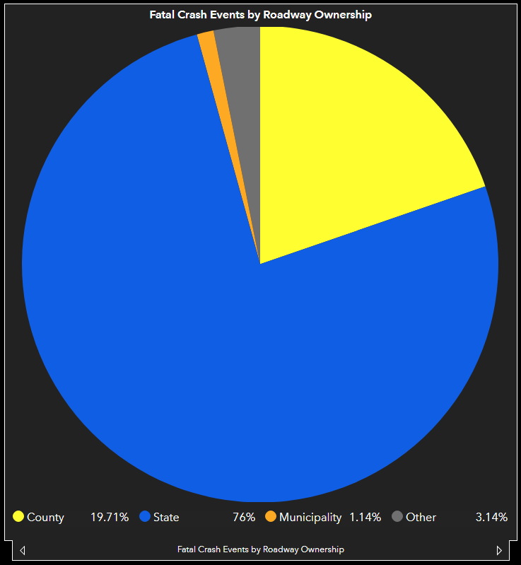
One notable detail the maps reveal is that 76% of fatal crashes, and 83% of pedestrian fatalities, occurred on state-owned roadways. This could be because state-owned highways often have higher speed limits than smaller county-owned streets. One of these roads, Indian Head Highway (Route 210), saw more than 300 total accidents each year between 2016 and 2019, WTOP reported — Prince George’s County Executive Angela Alsobrooks called it a “death trap.” The high prevalence of serious crashes on state-owned roads means the county will have to work in collaboration with the state to make changes.
Knowing where collisions occur can help emergency responders with new routing; It can set traffic enforcement priorities; it can show where safety education campaigns can be best deployed; it can identify whether disadvantaged neighborhoods are disproportionately impacted to better further equity goals; and it can help direct where new roadway safety engineering features can be built. Perhaps most importantly, public data lets advocates see where they need to push for better safety measures. Publishing data alone won’t get Prince George’s County to Vision Zero, but it’s a good first step.