What Tysons can learn about walkways and mall paths from other cities
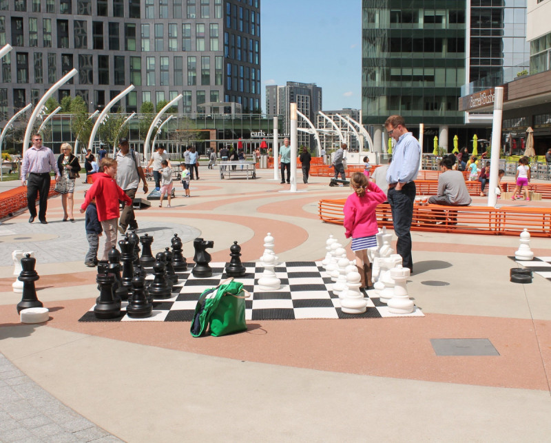
Tysons Corner Center by Elvert Barnes licensed under Creative Commons.
Tysons is evolving from suburb to city, but try to walk around and it still feels disjointed, with very long walks from one block to the next. Filling in these spaces is a growing network of non-street paths, including elevated walkways and mall promenades.
Redevelopments like The Boro include new streets, alleys, and walkways in the middle of blocks, and such forms have been cropping up all over Tysons. Bridges across Routes 123 and 7 provide access to the Metro while also connecting neighborhoods to one another. Some of these are privately owned yet open to the public, rather than true public spaces.
Will these give Tysons the walkable feel its leaders strive for? We can learn from other cities around the world that have built private paths and elevated walkways like those that are rapidly sprouting in Tysons.
What makes a network walkable?
To understand the importance of walkability, just ask a realtor. In the Washington region, homes in walkable communities command a 67% rent premium. But it’s not always intuitive what makes a place walkable.
One of the most important characteristics is a highly-connected network of walkways. The connectivity of the walkway network determines how many destinations you can reach from wherever you’re starting - whether those destinations are jobs, restaurants, transit stops, friends, or dog parks. A more densely-connected network can expand your world.
Clarendon (right) has a very tightly connected pathway network, and pedestrians can access many destinations easily. Shady Grove (left) doesn’t. Image by Metropolitan Washington Council of Governments. 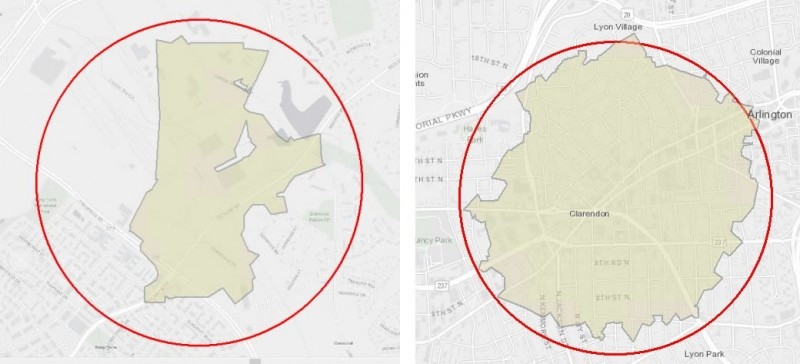
But the walkway network in Tysons is very poorly connected. Tysons was built on a ‘superblock’ plan - a style of Modernist city planning popular in the 1960s and ’70s. Superblocks keep intersections far apart in order to minimize the number of red lights a driver waits at, with the side effect of building a skeleton of a pedestrian network that’s practically unusable for walking to a destination. For the Tysons of the late 20th century this model worked well enough. It kept cars moving and traffic was bad but not intolerable. But it can’t last forever.
The Tysons of the 21st century has already committed to be a hub of 100,000 residents and twice that many jobs by 2050. In this hive, there won’t be enough space for everyone to get around in their own car. Fortunately, as Tysons grows, all of this activity will get closer and closer together. If we build a tightly-connected walkway network, Tysonians will be able to get from their homes to their jobs to their dinner dates all on foot. If we don’t keep pace, traffic will only get worse until the city grinds to a halt.
Anyone strolling from Towers Crescent to the Tysons Corner Metro station will find it most convenient to take the skyway connecting their building to the Tysons Corner Center mall’s parking garage, walk across the garage, and go through the mall to get to the train.
The path from Towers Crescent to the Metro station, by way of: a bridge over a road, a parking deck, another short bridge, a mall interior, a privately-owned above-grade plaza, and three more bridges above roads. This is almost certainly the quickest path between these points. Image via Google Maps. 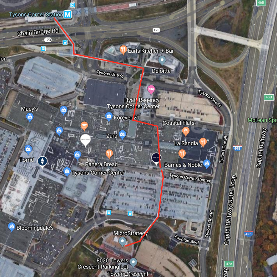
Elevated and privately-owned public space
To analyze the kind of space I’m talking about, we have to isolate two defining characteristics. First, at least some of it is elevated, a space dedicated to pedestrians above the asphalt of the roads, with buildings connected by bridges. Elevated pedestrian bridges are generally considered to be very bad for walkability, but there are a handful of exceptions that we’ll discuss.
Second, it is a privately-owned public space, where most people are generally free to use, but where private owners are able to enforce their own regulations, negotiated along with governmental ones. It happens that the Tysons Corner Center is both elevated and privately-owned, but it’s quite possible to have one without the other.
These ways of using space aren’t exactly a revelation. Let’s take a tour around the world, as we investigate comparable spaces.
6½th Avenue creates a shortcut for pedestrians. by Z22 licensed under Creative Commons.
New York City, USA: 6½th Avenue
Manhattan’s ‘6½th Avenue’ connects a corridor of interior midblock passageways for half a dozen blocks, meaningfully improving connectivity in a busy part of midtown that already has a tight street grid. It’s a privately-owned public space, but instead of being elevated it’s at street level. It connects directly to the conventional pedestrian infrastructure of sidewalks and crosswalks, and the passageways are linked to each other by crosswalks, not bridges. That means that it enhances pedestrian activity on the already-bustling street, rather than drawing people away from it.
Abdali Boulevard at night. by Yanal Tayyem on Unsplash licensed under Creative Commons.
Amman, Jordan: Abdali Boulevard
Amman’s Abdali Boulevard, like 6½th Avenue, is a privately-owned public space that is not elevated. Pedestrian-only, mixed-use, outdoors, studded with elegant 21st-century Levantine architecture, it is little more than a grandiose open-air shopping mall. Abdali Boulevard is linear in form and lies at grade, but unlike traditional boulevards it stands apart from Amman’s neighborhoods rather than connecting them.
Commentators on Jordanian urbanism don’t tend to focus on connectivity in their critiques. Moreoften, they take aim at Abdali Boulevard’s neoliberal nature as an exclusive privately-owned public space, a slice of Dubai dropped into Amman. Private cops guard all entrances, turning away most young men - especially the poorer, darker-skinned ones - for fear of the ‘nuisance’ they might cause to the elite women and families shopping there. Several times while living in Amman, I was told at the gates that I could not enter, that the Boulevard was for families only, only to be admitted with deference after I switched from Arabic to English.
Skyways in Minneapolis draw pedestrians off the streets, which in turn become an inhuman zone of asphalt and concrete Image by Tony Webster licensed under Creative Commons..jpg)
The skyways of Minneapolis
Minneapolis’ Skyway system is 11 miles long, dominating the city’s downtown. It’s both elevated and privately-owned. The network was born during the ’60s, as the world of design was burning with architectural Modernism’s drive for segregation of uses. Minneapolitans dreamed of a clean, airy, climate-controlled realm where people would promenade as cars whizzed around the dirty, frigid streets below.
That dream, some say, has become a nightmare. The elevated walkways pull people off the streets and away from each other. “They suck the public life out of the city,” said one critic. Because of their maze-like circuitousness, it’s not clear that these skyways offer significant improvements to connectivity. Mainly, they help pedestrians by letting them cross busy streets full of cars - a function accomplished in New York by crosswalks.
It’s worth noting that Minneapolis’ system wasn’t centrally planned. Rather, it grew organically. Commentators Jennifer Yoos and Vincent James refer to the process as ‘autocatalytic’, finding that “once established, such systems tend to expand, incrementally and informally, according to private and public development interests.”
Central Escalator in Hong Kong by WingLuk licensed under Creative Commons.
Hong Kong’s elevated walkways
Hong Kong’s elevated pedestrian network is the most extensive in the world, and closely resembles that of Minneapolis. It, too, grew organically, a fusion of private interest and public regulation sprouting out from a single elevated crossing built in the 1960s. However, three characteristics distinguish Hong Kong’s system from Minneapolis’: its transit-orientation; its more public nature; and its much denser population.
Hong Kong boasts an extensive and sophisticated public transit system, used by nine-tenths of the population. Buildings there are designed with the pedestrian and transit rider in mind. The shops and businesses of the elevated walkways certainly benefit from the transit system— but the relationship may be more parasitic than symbiotic.
GGWash contributor Payton Chung points out that:
“when private firms are put in charge of designing pedestrian circulation networks, they will place their values — primarily shuffling eyeballs past storefronts — over the public’s need for legible, direct links from A to B… [O]nce the development has cornered the transit station, it will seek to entrap the resulting pedestrian flows within a spiderweb of passages.”
This can easily defeat any advantage that internal mall connectivity brings to the pedestrian network.
It’s an understatement to say that Hong Kong’s private and public sectors play different societal roles from the US. Writer and architect Jonathan Solomon, author of a book on the subject, describes that city’s skyways, concourses, and atriums as ‘aformal’, rather than formal or informal. “It’s a collaboration between top-down government planning and kind of bottom-up market emergence that really wouldn’t function without the participation of the other,” he says.
In the US, building owners can close privately-owned interior public spaces at night, looking out for their self-interest and saving on maintenance but denying use of the space to late-night service workers and other nocturnal wanderers. In Hong Kong, the more powerful city government can mandate that such spaces stay open all night long. And, indeed, the public has taken a sense of ownership over these spaces. Solomon describes how on Sundays, the skyways fill with picnicking Filipina domestic migrant workers, who, lacking formal residency rights, have nowhere else to go. These aformal places even pass the supreme test of public space: being used as venues for public protest.
Density is another key difference. The ‘Fragrant Harbor’ reaches population densities above 100,000 people per square kilometer, 10 times as dense as the most compact parts of Minneapolis or Fairfax, making pedestrian infrastructure there all the more important. An additional point is that Hong Kong is a much hillier place than Minneapolis, and even more so than Tysons, and skyways are often helpful for connecting spaces that might otherwise require climbing a steep flight of stairs.
Back to Tysons
After this worldwide tour, what lessons do we have for Tysons? How can we avoid the pitfalls of Minneapolis and Amman while pursuing the glimmers of hope from New York and Hong Kong?
These questions, like all in urban planning, are up for debate, but I will offer two general conclusions on the potential of privately-owned public spaces in Tysons. First, to improve walkability, these spaces should be supplemental to a pedestrian network that fully functions in its own right. Second, for the sake of community, these spaces should feel a heavy hand of public authority.
Lesson 1: Supplement sidewalks, don’t replace them
In New York, a few shortcuts through office buildings contribute solidly to a neighborhood’s walkability. In Amman, a pedestrian-only ‘boulevard’ of gorgeous landscape architecture provides no meaningful improvement to connectivity. What’s the difference?
The difference is that in New York, the privately-owned public spaces add to an existing system of pedestrian infrastructure. They address an issue, though minor, in midtown’s sidewalk network (namely, that long blocks are pretty dang long). In Amman, to the contrary, the Abdali Boulevard ignores both the flaws and the strengths of the existing walkway network - even though surrounding neighborhoods, especially to its east and south, really are very walkable. Rather, it sets itself apart as a destination. Like Tysons’ malls in their suburban mode of decades past, it is a place meant for walking that can only be easily reached by car.
What changes will make Tysons more walkable?
To avoid falling in the footsteps of Abdali, future such development in Tysons should ensure that it is connected to the existing network in as many places as possible - yes, by bridges, but also by pathways, sidewalks, and especially new mid-block crosswalks. Fairfax planners should also continue to take every opportunity to use the development proffer process and Tysons tax district to channel money into public improvements to walkability around developments.
If the Abdali Boulevard fails because it seeks to remove itself from the city’s sidewalks, Minneapolis’ skyway system fails because it seeks to replace them. At its most ambitious, that network is trying to bring all pedestrian traffic into the air—abandoning the streets below to cars. Such a goal is neither practical nor desirable (even in Hong Kong, ¾ of people prefer to walk at street level) nor at all good for property values.
This approach—replacing street-level walking, rather than supplementing it—is a real risk for Tysons. For Tysons to achieve its goals of a sustainable, livable future, it must accomplish the goal of the Tysons Comprehensive Plan to transform routes 123 and 7 into “tree-lined boulevards designed to calm traffic through the most urban parts of Tysons while still moving traffic.” Because they distract from the need for safe at-grade crossings, pedestrian bridges over these roads are incompatible with that plan - though bridges over freeways like the Beltway are crucial.
This infographic from the (from my organization, though I didn’t make it) shows the advantage of at-grade crossings over pedestrian bridges. An article explains more. Image by Institute for Transportation and Development Policy used with permission.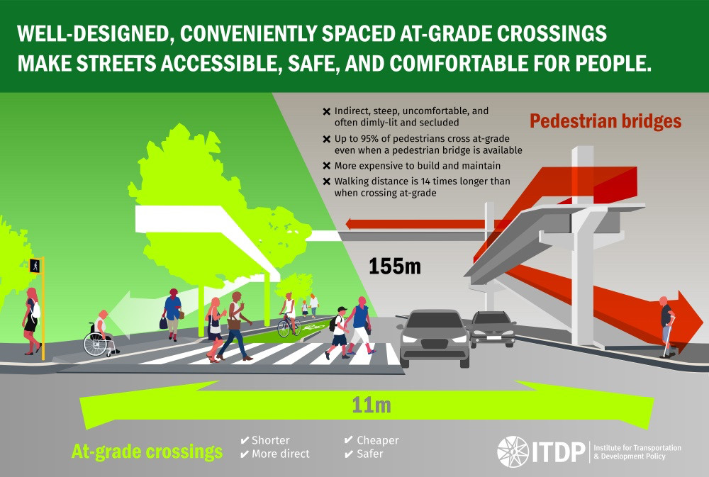
From our vantage point in 2020, it’s impossible to imagine the new forms that indoor/outdoor walkable urbanism could take. Might we one day see a track of lanes for e-scooters, from the metro station to the neighborhoods by way of the indoor mall? Might we one day see an indoor forum, like Rotterdam’s biophilic market hall? Or a civic use, like a school or library, built along such a framework?
I’ve used Tysons Corner Center as an example, but it is far from the only building that can find new ways of fitting into Tysons’ walkable grid. Other buildings, old and new, share many of the same attributes — especially when they’re large enough that it’s a hassle to walk around them rather than through.
Tysons is still inchoate, waiting to take form. That form will probably continue to have enormous shopping malls and other large buildings with interior spaces and passageways. But we have not yet decided whether those spaces will contribute to sustainability by facilitating walkability and transit use between many origins and destinations, or whether they will instead remain designed specifically to convey people to their own shops and businesses. I’ve done my best to gesture at a few solutions using the tools of urban design, but to make bring those solutions to reality we’ll need to look beyond design and enter the world of the political.
Lesson 2: Power to the public
Tysons wants to be “America’s Next Great City.” But a real city can never be found in a landscape of gated enclaves, whether they tower into the sky or sprawl into subdivisions. It must be a place with a true public realm, where all are welcome. For Tysons to overcome its reputation as a culturally-inauthentic fabricated suburb, it must find the strength - whether by way of the Tysons Partnership, Fairfax County, or some other public party - to ensure that its new urban places are truly for all people.
The ingredients are already here. Most development is already discretionary. Many public outdoor streets are already privately-owned.
In Hong Kong, a strong city government protects the right of ordinary citizens to assemble, whether for protest or for picnics. High population density and unique geography have left the city with indoor elevated walkways and galleries instead of the European-style public squares and alleyways. But rather than surrender those spaces to the control of wealthy elites, the hand of the city government has ensured that they are open, like the sidewalks below them, to all parts of the lives of the residents.
Just as important, strong public regulation can ensure that the pedestrian connections are designed in a way that contributes to walkability, with direct paths and many connections to sidewalks, rather than in a way that maximizes profit for a few individuals at the expense of the overall community.
Gruen’s Dream
The Austrian architect Victor Gruen designed the first shopping mall in the US and was one of the key figures behind Minneapolis’ skyways. Gruen idealistically hoped to give Americans the public realm he treasured in his native Vienna—sidewalk cafes, civic spirit, and serendipitous encounters with neighbors. Some 60 years later, Tysons has a chance, though it will take struggle, to revamp the mall’s purpose and bring Gruen’s dream to reality.
“Summer in the Sprawl, the mall crowds swaying like wind-blown grass, a field of flesh shot through with sudden eddies of need and gratification… He shifted on the concrete, feeling it rough and cool through the thin black denim. Nothing here like the electric dance of Ninsei. This was different commerce, a different rhythm, in the smell of fast food and perfume and fresh summer sweat”
-William Gibson, Neuromancer