In just 5 hours, volunteers collected over 300 bike lane violations in Arlington

All images by the author.
On October 17, 40 volunteers and I spread out across bike lanes in Crystal City, Rosslyn, and Ballston to see just how many drivers stop in or otherwise block bicycle lanes. We collected more than 300 bike lane violations in just five hours!
The “How’s My Driving” app beta test has been ongoing since January of this year with over 16,000 submissions logged to date, primarily in DC. Daniel Schep and I built the app to crowdsource dangerous driving behavior in a systematic way, and integrate it directly with city agencies like traffic/parking enforcement, transportation departments, urban mobility operators. The ultimate goal is to help make our streets safer.
All the while, our friends across the river in Arlington have been watching our progress, and interest from our NoVa neighbors galvanized around our collective action events like the Data Protected Bike Lanes Project in May and the H/I St Bus Lane Blitz in August. Beta testers started using the app in Arlington, and several of them reached out to me about bringing a more fully realized version to Northern Virginia.
So this summer, we began conversations with Arlington County officials about using the app in Arlington to aid enforcement efforts and drive infrastructure changes. The conversations went well, but the common chorus was “we need to see this app work in a location context at scale.” So to show what the app can do, we put together the second edition of the Data Protected Bike Lanes Project (#DataPBL). You can read about the first one here.
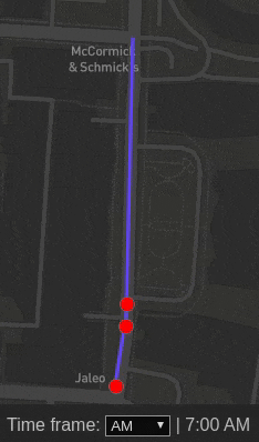
Starting at 7 am, volunteers began monitoring Crystal Drive, N Lynn Street, and Fairfax Drive (near Ballston Metro) and were able to track our collective progress via the real-time dashboard below.
Diving into the data

Crystal Drive accounts for 65% of all violations collected during DataPBL. N Lynn St (Rosslyn) was the most consistent throughout the day with about two dozen submissions per shift. Lunchtime seems to most problematic in Rossyln—volunteers collected the same number of violations in one hour at lunch as two rush hour shifts.
DataPBL Arlington was originally scheduled for Wednesday, October 16, but we moved the event due to bad weather. As a result, we lost a few volunteers on Fairfax Drive and didn’t have any coverage at lunchtime in Ballston.

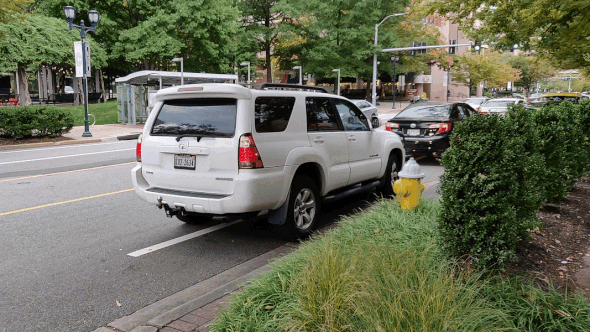
Diving deeper geographically from streets to blocks and overlaying vehicle type, a story starts to emerge from the data. We already knew the majority of bike lane blockages were on Crystal Drive, but now we can see that the 2100 block of Crystal Drive is where all the action is, why? Chick-fil-a!
I was personally stationed on the 2100 block for several shifts throughout the day, and at any given time you could easily mistake the bike lane for a curbside parking zone. Most were single-passenger private vehicles that would beeline directly to Chick-fil-a to score their coveted chicken sandwich.
Given the primary destination on the block, private vehicle violating at a rate of two to one over ride-hailing/taxis makes sense. Just one block away on 2000 Crystal Drive, there was an even split between private and ride-hailing vehicles, as this block’s primary destination is an office building.
A similar dynamic exists on N Lynn Street with the 1900 block of Lynn an office building where ride-hail/taxi violations dominant and the 1700 & 1800 blocks have food destinations, so more private and commercial vehicles are in the mix.
The actual impact
The quantity of violations certainly tells a story, but what about the vehicle that blocks a bike lane for 10, 15, or 20 minutes? How can we capture that tour bus that drops off an entire busload of 8th-grade tourists?
Entire Charter Bus unloading in bike lane #DataPBL pic.twitter.com/Y5K1lWGwRt
— Mark Sussman October 17, 2019
Luckily, the app has a vehicle status field, allowing volunteers to denote whether the vehicle was loading, standing or parked. In order to try and visualize the actual impact, How’s My Driving app co-founder Daniel Schep put together this time-lapse animation of the 2000-2200 blocks of Crystal Drive.
Some key assumptions
- All parking and commercial loading violations lasted 10 minutes
- Standing violations lasted five minutes
- Private and ride-hail/taxi loading violations lasted one minute
Using the same assumptions, now let’s see what percentage of time each bike lane block was impacted by violations as a percentage of total time monitored.

A reminder that we had to make assumptions about vehicle violation duration, but the 2100 Crystal Drive being impacted nearly all of the time volunteers monitored the bike lanes is not surprising. Beyond that staggering statistic on Crystal Drive, all of the blocks of N Lynn Street were impacted for nearly a third of the time.
The 1700 and 1800 blocks of N Lynn had less violations than the 1900 block, but these violations had a greater proportion of parking and standing violations as compared to the 1900 block. By estimating impact instead of just analyzing raw counts of violations, we begin to see how ineffective these bike lanes are in their current configuration.
What’s next?
It cannot be said enough that data like this has never been collected in a systematic way at scale before. With beta testing for a little under a year, we’re just now starting to understand how valuable this data can be as we work toward making our streets safer for everyone.
I’ll be sharing this analysis with Arlington officials in order to garner support for directly integrate the app with county partner to aid enforcement and infrastructure improvement efforts.
We’ll also be making similar efforts in other regional municipalities like Alexandria and Montgomery County. Follow the app on Twitter and/or sign up for the beta test to stay up to date.