Fairfax County built a levee to protect from floods. How’d it hold up in Monday’s storm?

The Hungtington levee Monday by Fairfax County Department of Public Works and Environmental Services.
On Monday morning, the Washington region experienced an intense storm with pouring rain and dangerous flooding. Metro stations turned into fountains, parking garages and roads became rivers, and dozens of people had to be rescued from rising flood waters.
The storm was also one of the first tests of the new Huntington levee in southeast Fairfax County, which was designed to protect around 160 homes in the Huntington neighborhood in Alexandria near the Huntington Metro Station from floodwaters off of Cameron Run, a tributary that feeds into the Potomac River a little more than two miles away.
Construction on the levee began in 2017 and finished in 2019. The county held a ribbon cutting ceremony in June. The levee is designed to keep water from Cameron Run contained inside the channel, and a pumping station at the end of the levee is designed to send water that pools on the ground back into the tributary.
As the rain fell, Cameron Run rose. As the videos below show, the water was muddy and fast moving.
I ran out during a break in the storm. pic.twitter.com/vFvOF63Bzs
— Joanne Tang (@JoanneLivesHere) July 8, 2019
For comparison, this is what it normally looks like.
I wonder how it looks by the levee. pic.twitter.com/GYTIZFhEk3
— Joanne Tang (@JoanneLivesHere) July 8, 2019
I spoke to Matthew Kaiser from the Fairfax County’s Department of Public Works and Environmental Services, who provided an update of the levee early yesterday afternoon after the storm had concluded.
“The Huntington levee is performing well,” Kaiser said. “The water on the Cameron Run side of the levee peaked just below elevation 12 [feet]. The ponding side of the levee reached elevation 5.1 [feet].”
To break down the numbers, that means a rise of more than 10 feet and five feet on the tributary and neighborhood sides of the levee, respectively. The levee was built to withstand higher elevations on both sides, and was designed to handle 100-year events, and handled this storm well. As photos and video show, while the waters were quite high, it didn’t reach the barrier on the Cameron Run side nor did it overwhelm the levee trail on the ponding side.
“The levee prevented significant structural flooding,” Kaiser said.
Photo taken facing east toward the pump house. Image by Fairfax County Department of Public Works and Environmental Services.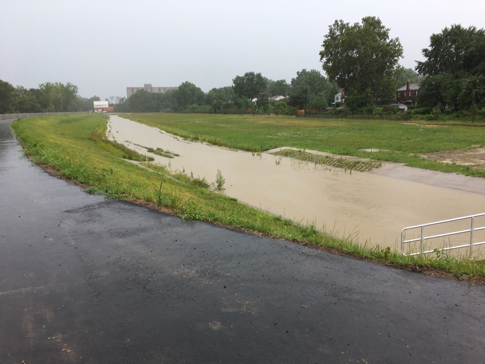
FEMA defines urban flooding as “inundation of property in a built environment, particularly in more densely populated areas, caused by rain falling on increased amounts of impervious surfaces and overwhelming the capacity of drainage systems.” But despite what the term “urban” implies, this kind of flooding happens in small towns, suburbs, and large cities—basically wherever we have a built environment and impervious surfaces, like parking lots and driveways.
As a result, a great deal of the country is vulnerable and in cities and towns where sprawl is dominant, this means the potential for more damage. Before the levee, there was only a park between the tributary and nearby homes, which meant that rising floodwaters would quickly spread across the grass and then overwhelm drainage systems.
Per an article from CityLab, urban flooding is understudied because it doesn’t always result from a devastating event that captures the country’s attention, like a hurricane. Urban flooding often comes from storms like the one we had Monday morning.
In the case of our region, the fact that our streets and Metro stations turned into rivers and overwhelmed our drainage systems means we need to be more prepared in the future. This requires approaching our top urbanist issues—from reducing reliance on cars and roads to zoning for single family homes—with an emergency management lens as well.
Storms like the one we saw Monday will only become more frequent as the climate crisis worsens. As we work on making the region a more walkable and bike-friendly place with a variety of affordable housing and more density, it’s critical that we also look at how our built environment affects our safety in extreme weather.