What we can learn from the history of DC’s circles and squares

Thomas Circle from the rooftop bar at The Donovan by BeyondDC licensed under Creative Commons.
Despite Washington’s status as the quintessential planned American city, key elements of the L’Enfant Plan have evolved over time. This is especially true of the core city’s squares and circles. From the 1870s up to the present day, competing interests—erecting monuments and memorials, preserving space for civic recreation, and catering to vehicular traffic—have led to drastic changes in our shared public spaces.
The history of these shared public spaces, and their varying uses over time, holds an important lesson for how we should think about them today.
Case studies from the 19th and early 20th centuries
A mere four blocks from the Capitol, Stanton Park nevertheless sat unimproved until 1879. With no curbs, sidewalks, or ornamental plantings in the way, Massachusetts and Maryland Avenues cut diagonally through the square, meeting at a small traffic circle in the center.
1876 real estate directory via National Park Service survey of Stanton Park, HABS DC-686 (1993). Image by Library of Congress.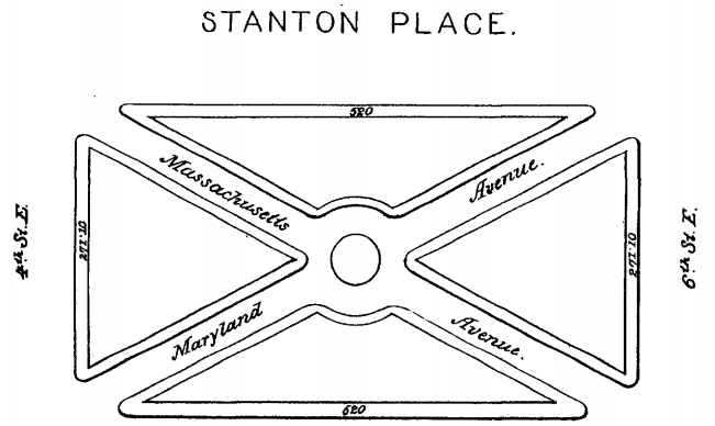
With the 1877 installation of the Statue of Gen. Nathanael Greene at the park’s center, plans to improve and unify the square followed swiftly, as did favorable newspaper reports:
The grounds are to be improved to correspond with the statue, being raised at its base some two feet and gently sloping to what is now the outside of the drive around the circle in the centre of the square. The roadways are to be closed, which will give the park a much larger appearance and cause it to present, with walks artistically laid out, a much handsomer appearance. When completed, Stanton square [sic] will be one of the prettiest of the many little “breathing holes” with which our city is blessed.
National Republican, Dec. 25, 1877. 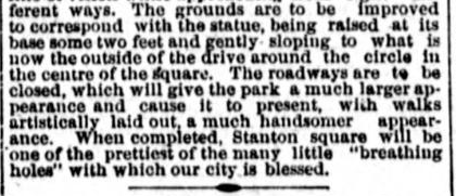
Hopkins atlas, 1887. 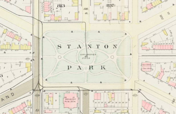
As Col. Thomas Lincoln Casey wrote in his 1879 report for the Office of Public Buildings and Grounds, “[t]he park was thoroughly improved in accordance with an approved plan, and the avenues and streets which intersected it and cut up the lawns into small and inferior patches of grass were removed.”
At the intersection of Pennsylvania Avenue and what is now called Potomac Avenue, a similar but more gradual story unfolded (at first, anyway). Although the federal reservation (No. 54) at this site was nominally rectangular, it developed initially as a six-way intersection with 14th Street SE.
Between 1893 and 1915, however, the intersection underwent a series of major changes. A new median on Pennsylvania blocked diagonal traffic on Potomac Avenue (named Georgia Avenue at the time) by 1903; by 1909, an expanded median blocked 14th Street as well; and shortly thereafter Reservation 54 evolved into a full rectangular island around which traffic flowed counterclockwise.
Hopkins atlas, 1893, showing intersection of Pennsylvania and Georgia (today, Potomac) avenues. 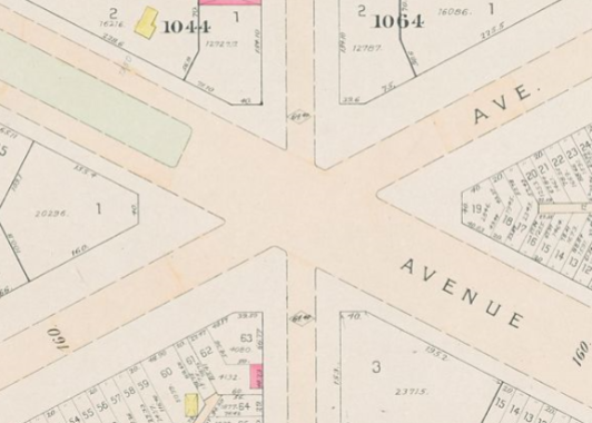
Baist atlas, 1909. 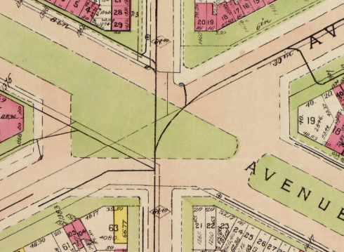
Baist atlas, 1921. 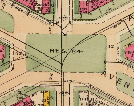
Planning for car priority
Unfortunately, the rise of the automobile and suburban commuter culture led to a very different series of changes from the 1930s through the '50s as Washington’s historic circles became inconvenient bottlenecks to impatient drivers. In the words of a 1949 Evening Star reporter, “[w]hatever their beauty, circles have been a major traffic headache in Washington ever since automobiles became more numerous than horses.”
1949 Evening Star article. 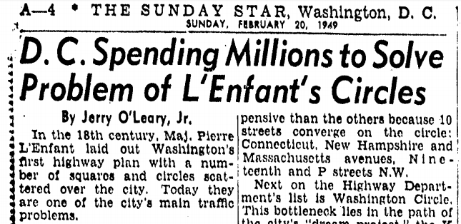
In a misguided initiative to increase traffic speeds and reduce congestion, District planners carved up many of the L’Enfant Plan circles and squares, reallocating park space into new roadway. For example, by 1938, Pennsylvania Avenue once against sliced straight through Reservation 54, a driver-centric configuration that has lasted for more than eight decades.
Aerial view, 1992. Image by Library of Congress, HABS report DC-707.
Worse was to come. Here is Logan Circle in 1948:
View west across Logan Circle (1948). Image by DDOT historic photos.
Image by DDOT historic photos.
And here is Logan Circle after it was hacked up in 1950 to route 13th Street through the park in the circle’s center:
Image by SDOT historic photos.
View of Logan Circle north along 13th Street NW (1970). Image by NPS HABS DC-339.
This was hardly the worst of the conversions. At least Logan Circle retained a large central park complete with walkways and accessible by crosswalk. By contrast, planners made even more radical changes to once-idyllic Thomas Circle.
Thomas Circle ca. 1906. Image by Library of Congress.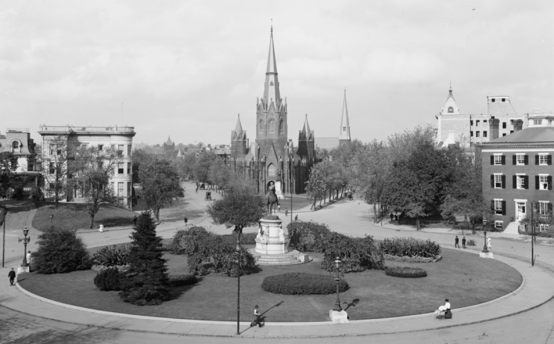
Beginning in 1942, the District completely re-engineered Thomas Circle’s traffic pattern, at first by tunneling Massachusetts Avenue under it and later by short-cutting 14th Street in another lemon-and-bananas configuration.
The result? Unappealing and inaccessible park islands in a sea of asphalt. In the words of the National Park Service survey, “the park that remained at the center was a shadow of its former self. Carved into a sodded lemon flanked by shrub-covered banana-shaped medians, no crosswalks led to the center park, making pedestrian access equivalent to jaywalking.”
Thomas Circle after reconstruction (1940s). Image by DDOT historic photos.
Thomas Circle in 1992. Image by Library of Congress.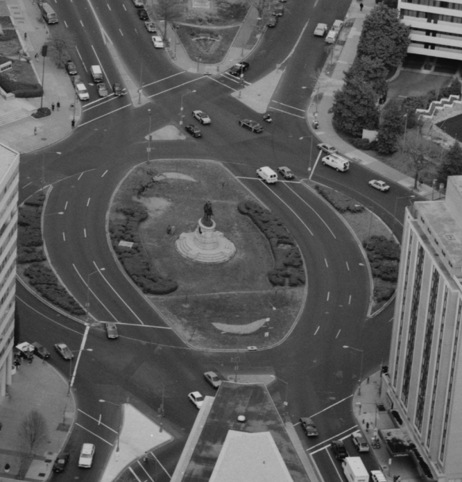
Truxton Circle—whose benches, extensive plantings, and large central fountain graced an urban park on North Capitol Street immediately north of Florida Avenue—simply ceased to exist in 1947.
View south across Truxton Circle (early 20th century). Image by Willard R. Ross Postcard Collection, DCPL.
View north-northeast across Truxton Circle (ca. 1916). Image by Army Corps of Engineers.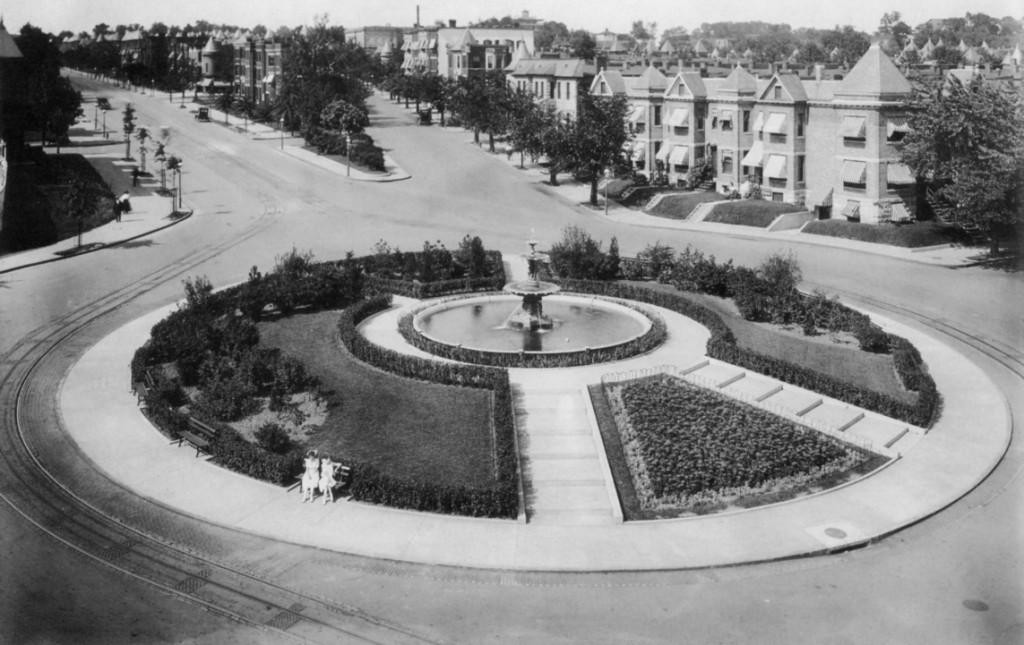
Referring to the circle as a “hazard” and “[o]ne of Washington’s most bothersome traffic bottlenecks,” a contemporary newspaper story repeated claims by city officials that the “channelization program … will assure safer, faster [sic] and more orderly traffic.”
Evening Star, March 24, 1947. 
View south across the former circle site, March 1967. 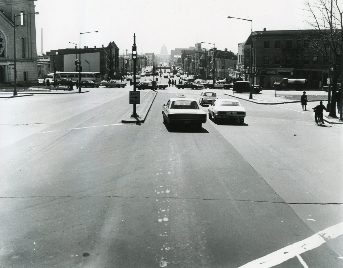
Dupont Circle proved to be a more difficult puzzle to solve. In the 1930s, motor-vehicle traffic and the resulting congestion increased markedly. Initially, District planners experimented with banning cars from the circle altogether.
Evening Star headline. 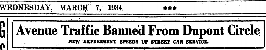
However, this plan was never made permanent; instead, the pendulum swung in the opposite direction, once again to prioritize motor vehicles.
Dupont Circle circa 1904; note broad sidewalk at right. Image by Library of Congress.
Starting in 1948, the wide sidewalk at the circle’s periphery was narrowed to create room for more roadway. Engineers also created a median to separate the two inner lanes—now dedicated exclusively to through traffic on Massachusetts Avenue—from the two outer lanes used to access other streets. At the same time, construction began on a tunnel to carry Connecticut Avenue and then-existing streetcar service under the circle, resulting in major (if temporary) disruption of the park itself.
View north along Connecticut Avenue, 1948. Image by DDOT photo archive.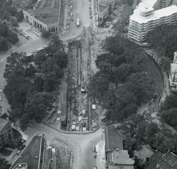
The pendulum swings back
Although many car-related incursions into the city’s important public spaces remain today, others were later rolled back. As the District’s population and economic prosperity declined in the 1950s and subsequent decades, planners and citizen groups took a greater interest in preserving the District’s historic buildings and neighborhoods, especially with the advent of home rule in 1973.
As these efforts took hold in Logan Circle, the 13th Street cut-through lanes were temporarily closed in 1981. Over the next three years, the National Park Service reclaimed that space and restored the circle to the conditions that exist today.
Similarly, in 2005-2006 the District Department of Transportation rolled back the Thomas Circle alterations made six decades earlier, thereby de-prioritizing motor-vehicle traffic and restoring pedestrian access to the expanded green space.
Thomas Circle after restoration, 2006. Image by DDOT historic photos.
More recently, DDOT has begun studying options for making the Pennsylvania/Potomac Avenue interchange safer for pedestrians. The final environmental assessment, issued in late 2017, recommends the creation of an ellipse park to calm traffic and provide safer and more direct pedestrian routes across the intersection. (Unfortunately, no construction money has been budgeted for the project to date.)
Selected design for Ellipse Park. 
Thinking about future District planning and land use
The history of these prominent public spaces teaches several lessons. The most important ones are twofold: first, that our urban environment is not static, but instead changes over time as a result of affirmative policy choices, and second, that the world doesn’t end when we no longer privilege drivers and their vehicles above other interests.
That doesn’t mean that every idea going forward necessarily involves tearing up roads and enlarging parks or sidewalks (although that’s sorely needed in many places, starting with Florida Avenue NE). We should also think creatively about ways to temporarily re-allocate space currently reserved for the exclusive use of cars.
This already happens in small ways, such as when neighbors apply to close off a street for a block party. But it can happen in other, more conspicuous ways, including in or near our landmark public spaces.
Just last week, DDOT announced the availability of grant money for Open Street proposals for “events where streets are periodically closed to motor-vehicle traffic and open to people for healthy activities suitable for all ages and abilities.”
Another good example involves the recent contretemps over DDOT’s proposed north-south bikeway west of Dupont Circle. When residents expressed concern over potential conflict with the Sunday farmers’ market on 20th Street, ANC 2B Commissioner Randy Dale Downs suggested relocating the market to occupy the circle’s two inner lanes:
Here is my idea! Use the inter-lane of Dupont Circle for the new location of @FRESHFARMDC market. Keep outer lanes open to vehicles, buses, & bike traffic. Allow market goers & public to hang out in Dupont Circle itself- eating, picnicking, playing chess, etc. A win, win, win! pic.twitter.com/RC4gGkLUWa
— Randy Downs (@RandyDaleDowns) February 13, 2019
The market organizers, DDOT, and ANC 2B continue to discuss the best way to move forward. (The next public meeting takes place on April 13.) But regardless of the outcome, Downs’s creative suggestion is a reminder that by definition, public space belongs to everyone. There are all kinds of opportunities to reclaim space from automobiles—either temporarily or permanently—for other, better uses.